Country:
 USA
USARegion:
City:
Latitude and Longitude:
Time Zone:
Postal Code:
IP information under different IP Channel
ip-api
Country
Region
City
ASN
Time Zone
ISP
Blacklist
Proxy
Latitude
Longitude
Postal
Route
IPinfo
Country
Region
City
ASN
Time Zone
ISP
Blacklist
Proxy
Latitude
Longitude
Postal
Route
MaxMind
Country
Region
City
ASN
Time Zone
ISP
Blacklist
Proxy
Latitude
Longitude
Postal
Route
Luminati
Country
USRegion
id
City
hagerman
ASN
Time Zone
America/Boise
ISP
ANTHEMBB
Latitude
Longitude
Postal
db-ip
Country
Region
City
ASN
Time Zone
ISP
Blacklist
Proxy
Latitude
Longitude
Postal
Route
ipdata
Country
Region
City
ASN
Time Zone
ISP
Blacklist
Proxy
Latitude
Longitude
Postal
Route
Popular places and events near this IP address
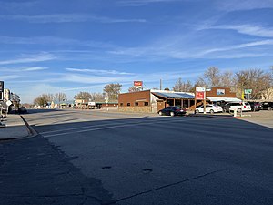
Hagerman, Idaho
City in Idaho, United States
Distance: Approx. 983 meters
Latitude and longitude: 42.81694444,-114.8975
Hagerman is a city in Gooding County, Idaho, United States. The population was 872 at the 2010 census, up from 656 in 2000. The area is noted for its fossil beds and the Thousand Springs of the Eastern Snake Plain Aquifer.

Hagerman Fossil Beds National Monument
Pliocene-age site near Hagerman, Idaho
Distance: Approx. 5631 meters
Latitude and longitude: 42.79027778,-114.94527778
Hagerman Fossil Beds National Monument is a Pliocene-age site near Hagerman, Idaho. The 4,351-acre (17.61 km2) Monument is internationally significant because it protects one of the richest known fossil deposits from the Blancan North American Land Mammal Age. These fossils date from 3.07 million to at least 4 million years ago in age and represent at least 200 species.

Malad River (Gooding County, Idaho)
River in Gooding County, Idaho in the United States
Distance: Approx. 5456 meters
Latitude and longitude: 42.8625,-114.905
The Malad River is a river located within Gooding County, and Oneida County, Idaho, United States, and is a tributary of the Snake River.
Archie Teater Studio
Historic house in Idaho, United States
Distance: Approx. 7589 meters
Latitude and longitude: 42.88,-114.91611111
The Archie Teater Studio, also known as Teater's Knoll, is a Frank Lloyd Wright designed Usonian home and art studio that was commission in 1952 with construction in Bliss, Idaho completed in 1957. The client, Archie Boyd Teater, was an American landscape and genre artist. The Teater Studio uses Oakley Stone in both the exterior and interior of the building.
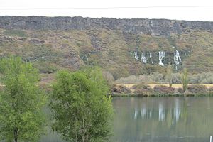
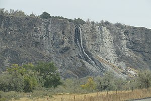
Thousand Springs State Park
Distance: Approx. 4755 meters
Latitude and longitude: 42.85777778,-114.87638889
Thousand Springs State Park is a public recreation and nature preservation area consisting of multiple units — Billingsley Creek, Earl M. Hardy Box Canyon Springs Nature Preserve, Malad Gorge, Niagara Springs, and Ritter Island — in Gooding County, Idaho.
Billingsley Creek Wildlife Management Area
Distance: Approx. 8864 meters
Latitude and longitude: 42.755419,-114.81455
Billingsley Creek Wildlife Management Area at 284 acres (1.15 km2) is an Idaho wildlife management area in Gooding County near the town of Hagerman. The WMA is in the Hagerman Valley near the Snake River and was purchased from the McCarther Cattle Company in September 1963. The area is managed for migratory waterfowl, and other wildlife includes raptors and small game animals.
Hagerman Wildlife Management Area
Distance: Approx. 5191 meters
Latitude and longitude: 42.769254,-114.878624
Hagerman Wildlife Management Area at 880 acres (3.6 km2) is an Idaho wildlife management area in Gooding County south of the town of Hagerman. The first land acquisition for the WMA was in 1940 and now includes land licensed from the U.S. Fish and Wildlife Service. The area is along the Snake River and attracts many birds, including ducks, geese, and raptors.
Lower Salmon Falls Dam
Dam in Twin Falls County / Gooding counties, Idaho
Distance: Approx. 3248 meters
Latitude and longitude: 42.841586,-114.903696
Lower Salmon Falls Dam is a concrete gravity-type hydroelectric dam on the Lower Salmon Falls of the Snake River, in the U.S. state of Idaho. The dam is located 5 miles downstream from Upper Salmon Falls, between Gooding County and Twin Falls County, Idaho.

Owsley Bridge
United States historic place
Distance: Approx. 5702 meters
Latitude and longitude: 42.764444,-114.889167
Owsley Bridge is a historic bridge spanning the Snake River on the Twin-Gooding county line in southern Idaho, United States, that is listed on the National Register of Historic Places.

Morris Roberts Store
United States historic place
Distance: Approx. 1138 meters
Latitude and longitude: 42.81194444,-114.89861111
The Morris Roberts Store, located off U.S. 30 in Hagerman, Idaho, was built in 1892. It was listed on the National Register of Historic Places in 1978. It is a one-story building with three-foot-thick lava rock walls, with a gabled roof.
Priestly's Hydraulic Ram
United States historic place
Distance: Approx. 8865 meters
Latitude and longitude: 42.743,-114.841
Priestly's Hydraulic Ram, located in Gooding County, Idaho near Hagerman, Idaho, was a hydraulic ram invented and built c. 1890. It was used to move water uphill to irrigate agricultural land on the plateau above the Snake River. It was located about 6 miles (9.7 km) south of Hagerman at Thousand Springs.
Weather in this IP's area
clear sky
23 Celsius
22 Celsius
21 Celsius
23 Celsius
1019 hPa
18 %
1019 hPa
918 hPa
10000 meters
5.96 m/s
7.34 m/s
272 degree
07:41:45
19:13:32