Country:
Region:
City:
Latitude and Longitude:
Time Zone:
Postal Code:
IP information under different IP Channel
ip-api
Country
Region
City
ASN
Time Zone
ISP
Blacklist
Proxy
Latitude
Longitude
Postal
Route
Luminati
Country
Region
on
City
peterborough
ASN
Time Zone
America/Toronto
ISP
NEXICOM
Latitude
Longitude
Postal
IPinfo
Country
Region
City
ASN
Time Zone
ISP
Blacklist
Proxy
Latitude
Longitude
Postal
Route
db-ip
Country
Region
City
ASN
Time Zone
ISP
Blacklist
Proxy
Latitude
Longitude
Postal
Route
ipdata
Country
Region
City
ASN
Time Zone
ISP
Blacklist
Proxy
Latitude
Longitude
Postal
Route
Popular places and events near this IP address

Peterborough Lift Lock
Boat lift
Distance: Approx. 4893 meters
Latitude and longitude: 44.3075,-78.30083333
The Peterborough Lift Lock is a boat lift located on the Trent Canal in the city of Peterborough, Ontario, Canada, and is Lock 21 on the Trent-Severn Waterway. For many years, the lock's dual lifts were the highest hydraulic boat lifts in the world, raising boats 65 ft (20 m). This was a considerable accomplishment in the first years of the 20th century, when conventional locks usually only had a 7 ft (2.1 m) rise.
CFFF-FM
Radio station in Peterborough, Ontario
Distance: Approx. 5000 meters
Latitude and longitude: 44.32805556,-78.29944444
CFFF-FM is a Canadian radio station, which broadcasts at 92.7 FM in Peterborough, Ontario. The broadcast facility, which uses the on-air name Trent Radio, was previously licensed as the campus radio station of the city's Trent University, but now operates under an independent community radio license. Trent Radio is producer-oriented, and features over 100 long-running and new programs from students and community members, operating over three seasons per year.
Canadian Canoe Museum
Museum in Ontario, Canada
Distance: Approx. 5175 meters
Latitude and longitude: 44.2982,-78.3013
The Canadian Canoe Museum, located in Peterborough, Ontario, Canada, is a museum dedicated to canoes.
CKWF-FM
Radio station in Peterborough, Ontario
Distance: Approx. 5000 meters
Latitude and longitude: 44.32805556,-78.29944444
CKWF-FM is a radio station in Peterborough, Ontario, Canada, broadcasting at 101.5 FM, with an active rock format branded as "The Wolf 101.5". The station is owned by Corus Entertainment.
Thomas A. Stewart Secondary School
Public high school in Peterborough, Ontario, Canada
Distance: Approx. 5860 meters
Latitude and longitude: 44.329374,-78.310204
Thomas A. Stewart Secondary School is a public secondary school located in Peterborough, Ontario, Canada. It was founded in 1967 and is located on 29 acres (120,000 m2) bordering on the Otonabee River. It is a member of the Kawartha Pine Ridge District School Board.

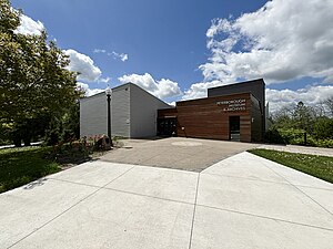
Peterborough Museum & Archives
History museum in Peterborough, Ontario, Canada
Distance: Approx. 5158 meters
Latitude and longitude: 44.30722,-78.30413
The Peterborough Museum & Archives, formerly the Peterborough Centennial Museum and Archives (PCMA), is a historical museum located in Peterborough, Ontario, Canada. Found only a short distance from the Trent-Severn Waterway National Historic Site of the Peterborough Lift Lock, the museum has a history spanning well over a century and is home to the second oldest historical collection of its kind within Ontario. Thousands of linear feet of archival materials and over 33,000 artifacts are included in the collection of which only 3% is displayed at any one time due to space restrictions.

CKQM-FM
Radio station in Peterborough, Ontario
Distance: Approx. 5000 meters
Latitude and longitude: 44.32805556,-78.29944444
CKQM-FM is a Canadian radio station, broadcasting at 105.1 FM in Peterborough, Ontario. Owned by Bell Media, the station airs a country format branded as Pure Country 105.
Peterborough Folk Festival
Music, arts, and community festival in Peterborough, Ontario
Distance: Approx. 5777 meters
Latitude and longitude: 44.3167,-78.3124
The Peterborough Folk Festival is a three-day music, arts, and community festival in Peterborough, Ontario. The festival is a non-profit organization which receives funding from the Lloyd Carr-Harris Foundation, The Department of Canadian Heritage -Arts Presentation Canada Program, and The City of Peterborough as well as private and corporate donations. It is one of the last free folk festivals in Ontario.

Little Lake (Peterborough)
Lake in Peterborough, Ontario
Distance: Approx. 5913 meters
Latitude and longitude: 44.2964916,-78.310271
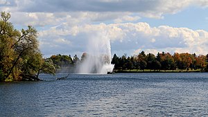
Little Lake is a small lake on the Otonabee River in the city of Peterborough, Ontario, Canada. The lake is in the downtown of the city and is used for fishing, swimming, boating, and for various special events. The lake lies on the water route from Lake Ontario to the Kawartha Lakes.

St. John the Evangelist Anglican Church (Peterborough, Ontario)
Church in Ontario, Canada
Distance: Approx. 6248 meters
Latitude and longitude: 44.30677778,-78.31786111
St. John the Evangelist Anglican Church is an Anglican church in downtown Peterborough, Ontario. Designed by William Coverdale and constructed in 1835–1837, it is considered one of the earliest stone Gothic Revival Anglican churches in Canada.

Immaculate Conception Church (Peterborough, Ontario)
Church in Peterborough, Ontario
Distance: Approx. 5525 meters
Latitude and longitude: 44.30568083,-78.30847583
Immaculate Conception Church is a Roman Catholic parish church in Peterborough, Ontario, Canada. It is located at 386 Rogers Street in the city's East City neighbourhood. It was the third parish church established in Peterborough.
Little Lake Cemetery
Cemetery in Peterborough, Ontario
Distance: Approx. 6096 meters
Latitude and longitude: 44.29291306,-78.31084778
Little Lake Cemetery is a non-denominational cemetery located in Peterborough, Ontario, Canada. It opened in 1850 and is located on the southern shore of Little Lake.
Weather in this IP's area
broken clouds
4 Celsius
2 Celsius
4 Celsius
5 Celsius
1033 hPa
35 %
1033 hPa
1007 hPa
10000 meters
2.51 m/s
3.41 m/s
90 degree
69 %
06:53:19
16:59:40
