Country:
 USA
USARegion:
City:
Latitude and Longitude:
Time Zone:
Postal Code:
IP information under different IP Channel
ip-api
Country
Region
City
ASN
Time Zone
ISP
Blacklist
Proxy
Latitude
Longitude
Postal
Route
IPinfo
Country
Region
City
ASN
Time Zone
ISP
Blacklist
Proxy
Latitude
Longitude
Postal
Route
MaxMind
Country
Region
City
ASN
Time Zone
ISP
Blacklist
Proxy
Latitude
Longitude
Postal
Route
Luminati
Country
USASN
Time Zone
America/Chicago
ISP
ESI
Latitude
Longitude
Postal
db-ip
Country
Region
City
ASN
Time Zone
ISP
Blacklist
Proxy
Latitude
Longitude
Postal
Route
ipdata
Country
Region
City
ASN
Time Zone
ISP
Blacklist
Proxy
Latitude
Longitude
Postal
Route
Popular places and events near this IP address
Mira Mesa, San Diego
Neighborhood of San Diego in San Diego, California
Distance: Approx. 3608 meters
Latitude and longitude: 32.91555556,-117.14388889
Mira Mesa (Spanish for "Table View") is a community and neighborhood in San Diego, California. The city-recognized Mira Mesa Community Plan Area is roughly bounded by Interstate 15 on the east, Interstate 805 on the west, the Los Peñasquitos Canyon on the north and Marine Corps Air Station Miramar on the south. Most of the community plan area is referred to as Mira Mesa; the community plan area also includes the neighborhoods of Sorrento Valley and Sorrento Mesa.
Miramar, San Diego
Community of San Diego in California
Distance: Approx. 2864 meters
Latitude and longitude: 32.88638889,-117.15777778
Miramar (Spanish for "Sea View") is a neighborhood in the northern part of San Diego, California, United States. It includes residential areas and commercial and light industrial districts. Most residents live on Marine Corps Air Station Miramar (formerly Naval Air Station Miramar).

Sorrento Valley, San Diego
Community of San Diego in California
Distance: Approx. 524 meters
Latitude and longitude: 32.9025,-117.18527778
Sorrento Valley is a neighborhood of San Diego, California. It is roughly bounded by Interstate 5 and Interstate 805, Camino Santa Fe to the east, the Los Peñasquitos Canyon Preserve to the north and Miramar Road to the south, as shown on the San Diego Police Department's neighborhood map. It encompasses Sorrento Mesa and is part of the San Diego Unified School District.

AleSmith Brewing Company
Craft brewery in San Diego, California
Distance: Approx. 3562 meters
Latitude and longitude: 32.89206667,-117.14468611
AleSmith Brewing Company is an American craft brewery located in San Diego, California. It specializes in handcrafted ales in a variety of styles. As of 2015 it produces about 25,000 barrels of beer a year.
Illumina, Inc.
American biotechnology company
Distance: Approx. 1949 meters
Latitude and longitude: 32.8875924,-117.1730577
Illumina, Inc. is an American biotechnology company, headquartered in San Diego, California. Incorporated on April 1, 1998, Illumina develops, manufactures, and markets integrated systems for the analysis of genetic variation and biological function.

Del Mar Mesa, San Diego
Community of San Diego in California, United States
Distance: Approx. 3643 meters
Latitude and longitude: 32.93666667,-117.18388889
Del Mar Mesa is a semi-rural residential community of 2,042 acres (8.26 km2) in northern San Diego, California. The majority of the community was developed in the 2000s. Over 900 acres is preserved open space protected habitat.

Los Peñasquitos Canyon Preserve
Distance: Approx. 3466 meters
Latitude and longitude: 32.93333333,-117.16722222
Los Peñasquitos Canyon Preserve is an urban park in San Diego, California. Stretching approximately 7 miles (11 km), the park encompasses some 4,000 acres (16 km2) of both Peñasquitos and Lopez canyons, and is one of the largest urban parks in the United States. The preserve is jointly owned and administered by the City of San Diego and the County of San Diego.

El Camino Memorial Park
Cemetery in Sorrento Valley, California, USA
Distance: Approx. 1416 meters
Latitude and longitude: 32.8931,-117.1876
El Camino Memorial Park is a cemetery in the Sorrento Valley neighborhood of San Diego, California. Founded in 1960, it is a 220-acre (0.89 km2) property. The cemetery is noted for being the final resting site for Jonas Salk as well as several members of the well-known Kroc family.
Ballast Point Brewing Company
Brewery in San Diego, California
Distance: Approx. 2760 meters
Latitude and longitude: 32.88753333,-117.15803056
Ballast Point Brewing Company is an American brewery founded in 1996 by Jack White in San Diego, California. Ballast Point Brewing Co. started in the back of Home Brew Mart, a homebrew supply store White founded in 1992.
Sorrento Mesa, San Diego
Distance: Approx. 1672 meters
Latitude and longitude: 32.88916667,-117.17805556
Sorrento Mesa is a neighborhood in northwestern San Diego, California. It lies on a mesa with many ridges, north of Carrol Canyon Road, east of Interstate 805, west of Camino Santa Fe, and south of a canyon locally known as Lopez Canyon. The San Diego Police Department's neighborhood map shows Sorrento Mesa as part of the Sorrento Valley neighborhood.
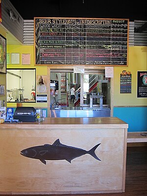
Green Flash Brewing Company
Distance: Approx. 387 meters
Latitude and longitude: 32.9068,-117.1774
Green Flash Brewing Company is an American craft brewery headquartered in the Mira Mesa neighborhood of San Diego, California, and founded in 2002. In early April 2018, the company sold to a group of investors, WC IPA LLC following a foreclosure by the company’s principal lender, Comerica Bank. Starting in 2013 it began expanding, seeking to cover all 50 US states and to export as well.

Miramar National Cemetery
Veterans cemetery in San Diego County, California
Distance: Approx. 3458 meters
Latitude and longitude: 32.87388889,-117.18861111
Miramar National Cemetery is a federal military cemetery in San Diego, California. It is located in the northwest corner of Marine Corps Air Station Miramar on the grounds of old Camp Kearny (1917) and Camp Elliott (1942). The cemetery is considered an auxiliary of Fort Rosecrans National Cemetery and is administered by the United States Department of Veterans Affairs.
Weather in this IP's area
fog
17 Celsius
17 Celsius
15 Celsius
22 Celsius
1011 hPa
86 %
1011 hPa
998 hPa
805 meters
2.57 m/s
280 degree
100 %
06:47:17
18:25:10