Country:
 USA
USARegion:
City:
Latitude and Longitude:
Time Zone:
Postal Code:
IP information under different IP Channel
ip-api
Country
Region
City
ASN
Time Zone
ISP
Blacklist
Proxy
Latitude
Longitude
Postal
Route
IPinfo
Country
Region
City
ASN
Time Zone
ISP
Blacklist
Proxy
Latitude
Longitude
Postal
Route
MaxMind
Country
Region
City
ASN
Time Zone
ISP
Blacklist
Proxy
Latitude
Longitude
Postal
Route
Luminati
Country
USRegion
nj
City
linden
ASN
Time Zone
America/New_York
ISP
AVSL-AS32957
Latitude
Longitude
Postal
db-ip
Country
Region
City
ASN
Time Zone
ISP
Blacklist
Proxy
Latitude
Longitude
Postal
Route
ipdata
Country
Region
City
ASN
Time Zone
ISP
Blacklist
Proxy
Latitude
Longitude
Postal
Route
Popular places and events near this IP address
Woolworth Building
Skyscraper in Manhattan, New York
Distance: Approx. 9 meters
Latitude and longitude: 40.71222222,-74.00805556
The Woolworth Building is a 792-foot-tall (241 m) residential building and early skyscraper at 233 Broadway in the Tribeca neighborhood of Lower Manhattan in New York City. Designed by Cass Gilbert, it was the tallest building in the world from 1913 to 1929, and remains one of the 100 tallest buildings in the United States as of 2024. The Woolworth Building is bounded by Broadway and City Hall Park to its east, Park Place to its north, and Barclay Street to its south.

Park Theatre (Manhattan)
Former theater in New York City
Distance: Approx. 97 meters
Latitude and longitude: 40.711512,-74.0076
The Park Theatre, originally known as the New Theatre, was a playhouse in New York City, located at 21–25 Park Row in the present Civic Center neighborhood of Manhattan, about 200 feet (61 m) east of Ann Street and backing Theatre Alley. The location, at the north end of the city, overlooked the park that would soon house City Hall. French architect Marc Isambard Brunel collaborated with fellow émigré Joseph-François Mangin and his brother Charles on the design of the building in the 1790s.

Astor House
Former hotel in Manhattan, New York
Distance: Approx. 67 meters
Latitude and longitude: 40.71180556,-74.00855556
The Astor House was a luxury hotel in New York City. Located on the corner of Broadway and Vesey Street in what is now the Civic Center and Tribeca neighborhoods of Lower Manhattan, it opened in 1836 and soon became the best-known hotel in America. Part of it was demolished in 1913; the rest was demolished in 1926.

City Hall Park
Public park in Manhattan, New York
Distance: Approx. 75 meters
Latitude and longitude: 40.71222222,-74.00722222
City Hall Park is a public park surrounding New York City Hall in the Civic Center of Manhattan. It was the town commons of the nascent city of New York.
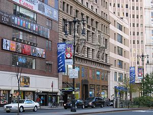
J&R
American electronics and music retailer (1971–2014)
Distance: Approx. 113 meters
Latitude and longitude: 40.71138889,-74.0075
J&R was an online electronics and music retailer, based in New York City, United States. It had a well-known retail location on Park Row in Civic Center, Manhattan, across from New York City Hall, from 1971 to 2014. J&R stands for the founders Joe and Rachelle Friedman who established the company in 1971 after emigrating separately from Israel as young children.
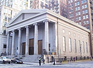
St. Peter's Church (Manhattan)
Historic church in Manhattan, New York
Distance: Approx. 120 meters
Latitude and longitude: 40.712488,-74.009501
Saint Peter's Church/Our Lady of the Rosary is a Catholic church in the Financial District of Manhattan, New York City. The current building was constructed from 1836 to 1840 and was designed by John R. Haggerty and Thomas Thomas in the Greek Revival style, with six Ionic columns. The church opened February 25, 1838 with Archbishop John Hughes officiating.
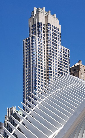
Barclay Tower
Residential skyscraper in Manhattan, New York
Distance: Approx. 84 meters
Latitude and longitude: 40.71219444,-74.00908333
The Barclay Tower is a skyscraper located in the Tribeca neighborhood of Lower Manhattan, New York City. The residential building rises 673 feet (205 m) above street level, containing 56 floors and 441 rental units. It is tied with One Grand Central Place as the 81st tallest building in New York.

City Hall Post Office and Courthouse (New York City)
Courthouse in Manhattan (1869–1939)
Distance: Approx. 68 meters
Latitude and longitude: 40.712,-74.0074
The City Hall Post Office and Courthouse was designed by architect Alfred B. Mullett for a triangular site in New York City along Broadway in Civic Center, Lower Manhattan, in City Hall Park south of New York City Hall. The Second Empire style building, erected between 1869 and 1880, was not well received. Commonly called "Mullett's Monstrosity", it was demolished in 1939 and the site used to extend City Hall Park to the south.

Millennium Park (Manhattan)
Traffic median in Manhattan, New York
Distance: Approx. 86 meters
Latitude and longitude: 40.71152778,-74.00819444
Millennium Park is a small plaza located at the intersection of Park Row and Broadway in Financial District of Lower Manhattan, New York City. Located to the south of City Hall Park, it is a Greenstreet site designed to replicate a forest amid a busy intersection. The plaza contains a bus turnaround loop, formerly a paved median transformed into a green space at the turn of the 21st century.
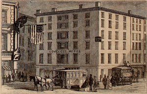
Lovejoy's Hotel
Distance: Approx. 123 meters
Latitude and longitude: 40.7115,-74.0071
Lovejoy's Hotel was a New York City hotel from the 1830s through 1870. It was located at the corner of Park Row and Beekman Street in a six-story building in the Civic Center neighborhood of Manhattan. The Astor House hotel was opposite it.

Transportation Building (Manhattan)
Office skyscraper in Manhattan, New York
Distance: Approx. 54 meters
Latitude and longitude: 40.712,-74.0086
The Transportation Building is a 44-story skyscraper at 225 Broadway on the corner of Barclay Street in the Civic Center neighborhood of Lower Manhattan in New York City. It also carries the address 2-4 Barclay Street. It was built in 1927 and was designed by the architecture firm of York & Sawyer, in the Renaissance Revival style, using setbacks common to skyscrapers built after the adoption of the 1916 Zoning Resolution.
1970 New York City gas explosion
Distance: Approx. 120 meters
Latitude and longitude: 40.71122,-74.00813
A gas explosion occurred on December 11, 1970, at a building at Park Row and Ann Street in Manhattan, New York City, killing 12 people and injuring more than 60. The two upper floors of the building had been recently converted into a Chinese restaurant, which required a new gas line to be installed. A city inspector failed to notice defects in the new line and issued a certification on December 2.
Weather in this IP's area
light rain
19 Celsius
19 Celsius
17 Celsius
20 Celsius
1009 hPa
78 %
1009 hPa
1008 hPa
10000 meters
5.14 m/s
230 degree
100 %
06:59:01
18:28:08