Country:
 USA
USARegion:
City:
Latitude and Longitude:
Time Zone:
Postal Code:
IP information under different IP Channel
ip-api
Country
Region
City
ASN
Time Zone
ISP
Blacklist
Proxy
Latitude
Longitude
Postal
Route
IPinfo
Country
Region
City
ASN
Time Zone
ISP
Blacklist
Proxy
Latitude
Longitude
Postal
Route
MaxMind
Country
Region
City
ASN
Time Zone
ISP
Blacklist
Proxy
Latitude
Longitude
Postal
Route
Luminati
Country
USRegion
id
City
ashton
ASN
Time Zone
America/Boise
ISP
ANTHEMBB
Latitude
Longitude
Postal
db-ip
Country
Region
City
ASN
Time Zone
ISP
Blacklist
Proxy
Latitude
Longitude
Postal
Route
ipdata
Country
Region
City
ASN
Time Zone
ISP
Blacklist
Proxy
Latitude
Longitude
Postal
Route
Popular places and events near this IP address

Ashton, Idaho
City in Idaho, United States
Distance: Approx. 6428 meters
Latitude and longitude: 44.07222222,-111.44777778
Ashton is a city in Fremont County, Idaho, United States. The population was 1,127 at the 2010 census, and it is part of the Rexburg Micropolitan Statistical Area. The district is noted for seed potato production and bills itself as the world's largest seed potato growing area.

Drummond, Idaho
City in Idaho, United States
Distance: Approx. 7193 meters
Latitude and longitude: 43.99916667,-111.34388889
Drummond is a city in Fremont County, Idaho, United States. The population was 16 at the 2010 census. It is part of the Rexburg, Idaho Micropolitan Statistical Area.
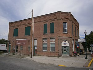
Independent Order of Odd Fellows Hall (Ashton, Idaho)
United States historic place
Distance: Approx. 6353 meters
Latitude and longitude: 44.07166667,-111.44694444
The Independent Order of Odd Fellows Hall in Ashton, Idaho, also known as the Ashton State Bank Building was constructed in 1907 in Early Commercial architectural style. Its historical use was as a meeting hall and for businesses. It was registered on the National Register of Historic Places in 1997.
Ashton to Tetonia Trail
Protected area in Idaho, US
Distance: Approx. 6367 meters
Latitude and longitude: 44.0715807,-111.4482884
The Ashton to Tetonia Trail is a 29.6-mile (47.6 km) rail-trail conversion built on the former Teton Valley Branch of the Union Pacific Railroad from Ashton to Tetonia, Idaho. The trail is used for hiking, biking, horseback riding, cross-country skiing, snowshoeing, and snowmobiling. Access points are found at Ashton, Marysville, Bitch Creek, Felt, and Tetonia.
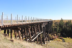
Conant Creek Pegram Truss Railroad Bridge
United States historic place
Distance: Approx. 5291 meters
Latitude and longitude: 44.014317,-111.364644
The Conant Creek Pegram Truss Railroad Bridge, in Fremont County, Idaho near Grainville, Idaho and Ashton, Idaho, was built in 1894. It brought a railroad over the Conant Creek, 1 mile south of the junction of Squirrel Rd. and the old Ashton-Victor railroad spur tracks.
Weather in this IP's area
clear sky
17 Celsius
16 Celsius
16 Celsius
19 Celsius
1021 hPa
23 %
1021 hPa
845 hPa
10000 meters
3.09 m/s
3.03 m/s
181 degree
07:28:38
18:59:01