Country:
 USA
USARegion:
City:
Latitude and Longitude:
Time Zone:
Postal Code:
IP information under different IP Channel
ip-api
Country
Region
City
ASN
Time Zone
ISP
Blacklist
Proxy
Latitude
Longitude
Postal
Route
IPinfo
Country
Region
City
ASN
Time Zone
ISP
Blacklist
Proxy
Latitude
Longitude
Postal
Route
MaxMind
Country
Region
City
ASN
Time Zone
ISP
Blacklist
Proxy
Latitude
Longitude
Postal
Route
Luminati
Country
USRegion
id
City
idahofalls
ASN
Time Zone
America/Boise
ISP
ANTHEMBB
Latitude
Longitude
Postal
db-ip
Country
Region
City
ASN
Time Zone
ISP
Blacklist
Proxy
Latitude
Longitude
Postal
Route
ipdata
Country
Region
City
ASN
Time Zone
ISP
Blacklist
Proxy
Latitude
Longitude
Postal
Route
Popular places and events near this IP address
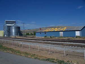
Iona, Idaho
City in Idaho, United States
Distance: Approx. 4358 meters
Latitude and longitude: 43.52638889,-111.92861111
Iona is a city in Bonneville County, Idaho, United States. It is part of the Idaho Falls, Idaho Metropolitan Statistical Area. The population was 1,803 at the 2010 census.

Ucon, Idaho
City in Idaho, United States
Distance: Approx. 6879 meters
Latitude and longitude: 43.59305556,-111.95972222
Ucon is a city in Bonneville County, Idaho, United States. It is part of the Idaho Falls, Idaho Metropolitan Statistical Area. The population was 1,108 at the 2010 census.
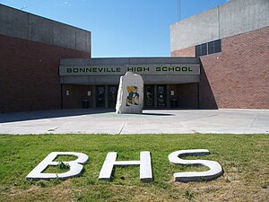
Bonneville High School (Idaho Falls, Idaho)
Public school in Bonneville County, Idaho, United States
Distance: Approx. 7146 meters
Latitude and longitude: 43.526,-111.971
Bonneville High School is a four-year public secondary school near Idaho Falls, Idaho. Northeast of the city, it opened in 1951 and is the original high school of the Bonneville Joint School District #93, which consolidated ten smaller districts east of Idaho Falls. The original building for high school was turned into a junior high in 1977 when the current Bonneville High School was built.

KUPI-FM
Radio station in Rexburg–Idaho Falls, Idaho
Distance: Approx. 1590 meters
Latitude and longitude: 43.542,-111.885
KUPI-FM (99.1 MHz) is a commercial radio station located in Idaho Falls, Idaho. KUPI-FM airs a country music format branded as "99 KUPI".
KGTM
Radio station in Shelley, Idaho
Distance: Approx. 1458 meters
Latitude and longitude: 43.543,-111.886
KGTM is a hot adult contemporary formatted radio station located in Shelley, Idaho, broadcasting to the Eastern Idaho area on 98.1 FM.
KIDJ
Radio station in Idaho, United States
Distance: Approx. 1458 meters
Latitude and longitude: 43.543,-111.886
KIDJ (106.3 FM) is a commercial radio station located in Sugar City, Idaho, broadcasting to the Idaho Falls area. KIDJ airs a news/talk format, formerly originated from KID (590 AM).

KID (AM)
Radio station in Idaho Falls, Idaho
Distance: Approx. 2362 meters
Latitude and longitude: 43.55972222,-111.92083333
KID (590 kHz) was a commercial AM radio station located in Idaho Falls, Idaho, broadcasting on 590 AM. KID aired news/talk programming, which included syndicated programs like Sean Hannity, Glenn Beck, and Ben Shapiro.
KNBL
Radio station in Idaho, United States
Distance: Approx. 9020 meters
Latitude and longitude: 43.52074722,-111.99330278
KNBL (1260 AM) is a radio station broadcasting a variety hits format. Licensed to Idaho Falls, Idaho, United States, the station serves the Idaho Falls–Pocatello area.
Lincoln, Idaho
Distance: Approx. 7490 meters
Latitude and longitude: 43.51305556,-111.96444444
Lincoln is a census-designated place in Bonneville County, Idaho located just east of Idaho Falls, southwest of Iona and north of Ammon. As of the 2010 census, its population was 3,647. Lincoln has an area of 1.465 square miles (3.79 km2), all of it land.
Beachs Corner, Idaho
Unincorporated community in the state of Idaho, United States
Distance: Approx. 5979 meters
Latitude and longitude: 43.5425,-111.96416667
Beachs Corner is an unincorporated community in Bonneville County, Idaho, United States. Beachs Corner is located at the junction of U.S. Route 26 and Idaho State Highway 43 5 miles (8.0 km) northeast of Idaho Falls. It is named after Aaron Williams Beach 1847-1912 who owned a farm there.
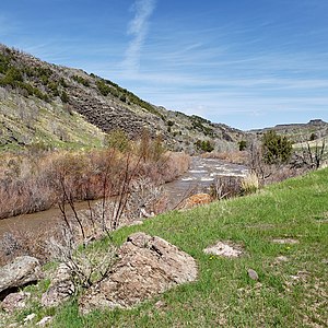
Willow Creek (Snake River tributary)
River in Idaho, United States
Distance: Approx. 7738 meters
Latitude and longitude: 43.55277778,-111.98805556
Willow Creek is a 84-mile (135 km) long tributary of the Snake River in the U.S. state of Idaho. Beginning at an elevation of 6,568 feet (2,002 m) east of the Blackfoot Mountains in southeastern Bingham County, it flows generally north into Bonneville County and past Bone. South of the town of Ririe, the creek is impounded by Ririe Dam, forming Ririe Reservoir.
Weather in this IP's area
clear sky
16 Celsius
14 Celsius
16 Celsius
17 Celsius
1021 hPa
32 %
1021 hPa
849 hPa
10000 meters
3.57 m/s
4.38 m/s
192 degree
07:30:12
19:01:08