Country:
 USA
USARegion:
City:
Latitude and Longitude:
Time Zone:
Postal Code:
IP information under different IP Channel
ip-api
Country
Region
City
ASN
Time Zone
ISP
Blacklist
Proxy
Latitude
Longitude
Postal
Route
IPinfo
Country
Region
City
ASN
Time Zone
ISP
Blacklist
Proxy
Latitude
Longitude
Postal
Route
MaxMind
Country
Region
City
ASN
Time Zone
ISP
Blacklist
Proxy
Latitude
Longitude
Postal
Route
Luminati
Country
USRegion
id
City
nampa
ASN
Time Zone
America/Boise
ISP
ANTHEMBB
Latitude
Longitude
Postal
db-ip
Country
Region
City
ASN
Time Zone
ISP
Blacklist
Proxy
Latitude
Longitude
Postal
Route
ipdata
Country
Region
City
ASN
Time Zone
ISP
Blacklist
Proxy
Latitude
Longitude
Postal
Route
Popular places and events near this IP address

Ford Idaho Center
Distance: Approx. 2354 meters
Latitude and longitude: 43.608106,-116.508175
The Ford Idaho Center is a complex of sports and entertainment venues in Nampa, Idaho, approximately 15 miles (24 km) west of Boise.
Snake River Stampede Rodeo
Distance: Approx. 2358 meters
Latitude and longitude: 43.60805556,-116.50805556
The Snake River Stampede is a rodeo held in Nampa, Idaho. It is one of the top twelve professional rodeos recognized by the Professional Rodeo Cowboys Association and is held for five days every year during the third week of July. There are many community events which help kick off the rodeo week.
Spirit of Flight Center
Distance: Approx. 1488 meters
Latitude and longitude: 43.5852,-116.5188
The Spirit of Flight Center (SOF), is operated by the non-profit Spirit of Flight Foundation, a 501(C)(3) organization based in Nampa, ID. The Spirit of Flight collection, founded by Gordon R. Page, displays limited exhibits on modern and historic aviation, and features aviation history from 1935 to 1975, both military and general aviation. Featured is a Messerschmitt Bf 109 F fighter from Russia. Also on display at SOF is a full-size bronze statue of Amelia Earhart.

College of Western Idaho
Community college in Boise and Nampa, Idaho, U.S.
Distance: Approx. 2871 meters
Latitude and longitude: 43.61416667,-116.50722222
College of Western Idaho (CWI) is a public community college in Southwest Idaho with its primary campus locations in Boise and Nampa. CWI also offers classes at several community locations throughout the Treasure Valley. It is one of four comprehensive community colleges in Idaho and is governed by a five-member board of trustees elected at large by voters in Ada and Canyon counties.

Nampa Municipal Airport
Airport
Distance: Approx. 1662 meters
Latitude and longitude: 43.58138889,-116.52305556
Nampa Municipal Airport (ICAO: KMAN, FAA LID: MAN, formerly S67) is a city-owned public airport in Nampa, in Canyon County, Idaho. The FAA's National Plan of Integrated Airport Systems for 2009–2013 called it a general aviation airport. It is used for private, emergency, military and industrial aviation and is home to the Warhawk Air Museum.
Nampa Gateway Center
Shopping mall in Idaho, United States
Distance: Approx. 1732 meters
Latitude and longitude: 43.59555556,-116.50972222
Nampa Gateway Center is a lifestyle center located in Nampa, Idaho, United States. The center is owned by Gardner Company and is anchored by Crunch Fitness, DEFY Trampoline Parks, House of Design Robotics, JCPenney, Shoe Carnival, and WinCo Foods.
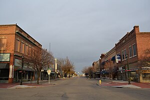
Nampa Historic District
Historic district in Idaho, United States
Distance: Approx. 2862 meters
Latitude and longitude: 43.57805556,-116.55777778
The Nampa Historic District is a 3-acre (1.2 ha) historic district in Nampa, Idaho that was listed on the National Register of Historic Places in 1983. The listing included 10 contributing buildings. Its National Register nomination described:The district is historically significant for its association with Nampa's commercial development during the period 1905 through 1920, a major period of growth during which Nampa's main street, First Street South, gained a full complement of two-story brick business blocks.: 3 It includes part or all of the 1200 and 1300 blocks of S. 1st St.
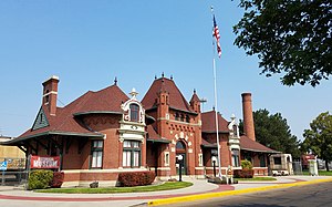
Nampa station
United States historic place
Distance: Approx. 2796 meters
Latitude and longitude: 43.5797222,-116.5586111
The Nampa Depot in Nampa, Idaho, is a former passenger station on the Oregon Short Line Railroad, designed by Frederick W. Clarke. The 1-story, brick and sandstone depot was described in 1972 by Arthur A. Hart, director of the Idaho State Historical Museum, as "an interesting eclectic combination of Romanesque, Renaissance, and Baroque elements, with the latter dominating. A massive central block of French Renaissance form is flanked by two advancing Baroque bays that bulge dramatically forward." The depot was added to the National Register of Historic Places in 1972.

Nampa and Meridian Irrigation District Office
U.S. historic building
Distance: Approx. 2863 meters
Latitude and longitude: 43.57638889,-116.55555556
The Nampa and Meridian Irrigation District Office in Nampa, Idaho, is a 1-story brick and concrete building designed by Tourtellotte and Hummel and completed in 1919. The building features tall, narrow window fenestrations topped by large, vertical keystones with sidestones. Most of the windows have been replaced by a flat stucco surface painted brilliant white.

Nampa Department Store
U.S. historic building
Distance: Approx. 2307 meters
Latitude and longitude: 43.58694444,-116.5575
The Nampa Department Store in Nampa, Idaho, is a 2-story, brick and stone commercial building designed by Tourtellotte and Hummel and completed in 1910. A 3-story building for the site had been ordered by Falk Mercantile Company, but when the site was developed, Leo Falk along with investor E.H. Dewey scaled back the design and opened the Nampa Department Store, built by contractor G.H. Rush. The building was added to the National Register of Historic Places in 1982.

Jacob P. Lockman House
United States historic place
Distance: Approx. 2736 meters
Latitude and longitude: 43.58277778,-116.56055556
The Jacob P. Lockman House is a historic house in Nampa, Idaho. It was built in 1906 for Jacob P. Lockman, a Danish immigrant who owned a saloon in Ketchum and served as the mayor of Wallace before opening a brewery in Nampa. The house was designed in the American Foursquare style.

Warhawk Air Museum
Military aviation museum in Nampa, Idaho
Distance: Approx. 1188 meters
Latitude and longitude: 43.586,-116.5235
The Warhawk Air Museum is a military service and aviation museum located in Nampa, Idaho.
Weather in this IP's area
clear sky
21 Celsius
19 Celsius
19 Celsius
22 Celsius
1020 hPa
25 %
1020 hPa
932 hPa
10000 meters
2.57 m/s
340 degree
07:48:48
19:19:39