Country:
 USA
USARegion:
City:
Latitude and Longitude:
Time Zone:
Postal Code:
IP information under different IP Channel
ip-api
Country
Region
City
ASN
Time Zone
ISP
Blacklist
Proxy
Latitude
Longitude
Postal
Route
IPinfo
Country
Region
City
ASN
Time Zone
ISP
Blacklist
Proxy
Latitude
Longitude
Postal
Route
MaxMind
Country
Region
City
ASN
Time Zone
ISP
Blacklist
Proxy
Latitude
Longitude
Postal
Route
Luminati
Country
USRegion
id
City
wendell
ASN
Time Zone
America/Boise
ISP
ANTHEMBB
Latitude
Longitude
Postal
db-ip
Country
Region
City
ASN
Time Zone
ISP
Blacklist
Proxy
Latitude
Longitude
Postal
Route
ipdata
Country
Region
City
ASN
Time Zone
ISP
Blacklist
Proxy
Latitude
Longitude
Postal
Route
Popular places and events near this IP address

Wendell, Idaho
City in Idaho, United States
Distance: Approx. 2451 meters
Latitude and longitude: 42.77611111,-114.70277778
Wendell is a city in southern Gooding County, Idaho, United States. The population was 2,782 at the 2010 census.
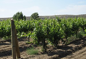
Idaho wine
Wine industry in US State:Idaho
Distance: Approx. 9620 meters
Latitude and longitude: 42.67515517,-114.75220137
Idaho wine refers to wine produced in the state of Idaho. Idaho has a long history of wine production with the first vineyards in the Pacific Northwest being planted here in the 1860s. Grapes were first planted in the state by French immigrants Louis Desol and Robert Schleicher, and Jacob Schaefer from Germany before grapes were ever planted in Washington and Oregon.
Wendell High School
Public school in Wendell, Idaho , United States
Distance: Approx. 3114 meters
Latitude and longitude: 42.77611111,-114.69111111
Wendell High School is a four-year public secondary school in Wendell, Idaho. It is the main high school operated by the Wendell School District.
KDIL
Radio station in Jerome, Idaho
Distance: Approx. 8407 meters
Latitude and longitude: 42.72722222,-114.62694444
KDIL (940 AM) is a licensed radio station with an FCC-issued license for Jerome, Idaho, United States. The station began broadcasting in November 2010 under Program Test Authority from the FCC and was licensed on February 15, 2011. The station broadcasts a Spanish adult hits format distributed by Orbital Media Networks.
Jessie Osborne House
Historic house in Idaho, United States
Distance: Approx. 9911 meters
Latitude and longitude: 42.72583333,-114.60777778
The Jessie Osborne House is a house near Jerome, Idaho that was listed on the National Register of Historic Places in 1983. It is an example of the simple rectangular gable-roofed houses built on farms in this area of Idaho. It is unique in that it has not been changed, added on to or enlarged.
Billingsley Creek Wildlife Management Area
Distance: Approx. 7686 meters
Latitude and longitude: 42.755419,-114.81455
Billingsley Creek Wildlife Management Area at 284 acres (1.15 km2) is an Idaho wildlife management area in Gooding County near the town of Hagerman. The WMA is in the Hagerman Valley near the Snake River and was purchased from the McCarther Cattle Company in September 1963. The area is managed for migratory waterfowl, and other wildlife includes raptors and small game animals.
Niagara Springs Wildlife Management Area
Distance: Approx. 9741 meters
Latitude and longitude: 42.670987,-114.71507
Niagara Springs Wildlife Management Area at 976 acres (3.95 km2) is an Idaho wildlife management area in Gooding County south of the town of Wendell. The Idaho Department of Fish and Game acquired land for the WMA from the Bureau of Land Management in 1971, purchased additional land in 1972 with federal and license funds, and obtained an additional parcel in 1973. The WMA includes land along the Snake River and on the canyon rim.
West Point Grade School
United States historic place
Distance: Approx. 6929 meters
Latitude and longitude: 42.72524,-114.79233
The West Point Grade School is a historic former school on East 3300 South in the village of West Point in Gooding County near Wendell, Idaho. It was listed on the National Register of Historic Places in 1982. It was built in 1941 by general contractor R. C. Fait to designs by prominent Boise architects Tourtellotte & Hummel.
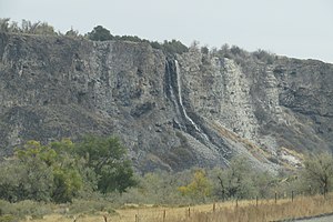
Priestly's Hydraulic Ram
United States historic place
Distance: Approx. 9990 meters
Latitude and longitude: 42.743,-114.841
Priestly's Hydraulic Ram, located in Gooding County, Idaho near Hagerman, Idaho, was a hydraulic ram invented and built c. 1890. It was used to move water uphill to irrigate agricultural land on the plateau above the Snake River. It was located about 6 miles (9.7 km) south of Hagerman at Thousand Springs.
Weather in this IP's area
clear sky
22 Celsius
21 Celsius
20 Celsius
23 Celsius
1019 hPa
21 %
1019 hPa
906 hPa
10000 meters
5.7 m/s
7.21 m/s
274 degree
07:41:04
19:12:54