Country:
 USA
USARegion:
City:
Latitude and Longitude:
Time Zone:
Postal Code:
IP information under different IP Channel
ip-api
Country
Region
City
ASN
Time Zone
ISP
Blacklist
Proxy
Latitude
Longitude
Postal
Route
IPinfo
Country
Region
City
ASN
Time Zone
ISP
Blacklist
Proxy
Latitude
Longitude
Postal
Route
MaxMind
Country
Region
City
ASN
Time Zone
ISP
Blacklist
Proxy
Latitude
Longitude
Postal
Route
Luminati
Country
USRegion
id
City
idahofalls
ASN
Time Zone
America/Boise
ISP
ANTHEMBB
Latitude
Longitude
Postal
db-ip
Country
Region
City
ASN
Time Zone
ISP
Blacklist
Proxy
Latitude
Longitude
Postal
Route
ipdata
Country
Region
City
ASN
Time Zone
ISP
Blacklist
Proxy
Latitude
Longitude
Postal
Route
Popular places and events near this IP address

Idaho Falls Idaho Temple
Temple of the LDS Church
Distance: Approx. 1674 meters
Latitude and longitude: 43.499819,-112.0415
The Idaho Falls Idaho Temple (formerly the Idaho Falls Temple) is a temple of the Church of Jesus Christ of Latter-day Saints in Idaho Falls, Idaho. The intent to build the temple was announced on March 3, 1937, by church president Heber J. Grant during the church's general conference. It is the church's tenth constructed and eighth operating temple, the first built in Idaho, and the first built with a modern single-spire design.
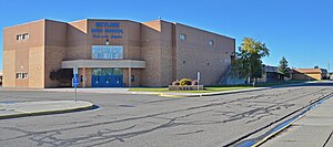
Skyline High School (Idaho)
Public school in Idaho Falls, Idaho, United States
Distance: Approx. 841 meters
Latitude and longitude: 43.487,-112.067
Skyline High School is a four-year public secondary school in Idaho Falls, Idaho, one of two traditional high schools of the Idaho Falls School District #91. The school opened in 1968 on the west side of Idaho Falls, west of the Snake River. The school colors are navy blue, white, and Columbia blue, and the mascot is a grizzly.

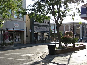
Colonial Theatre (Idaho Falls, Idaho)
Distance: Approx. 1443 meters
Latitude and longitude: 43.49305556,-112.04138889
The Colonial Theater is a historic theater in Idaho Falls, Idaho, founded in 1919 as a venue for live performances. From 1929 until 1990, it operated as a movie theater under the name The Paramount Theater. In the 1990s, the theater was renovated, and its original name was restored.
Idaho Falls metropolitan area
Metropolitan Statistical Area in Idaho, United States
Distance: Approx. 1160 meters
Latitude and longitude: 43.5,-112.05
The Idaho Falls Metropolitan Statistical Area, as defined by the United States Census Bureau, is an area consisting of three counties in eastern Idaho, anchored by the city of Idaho Falls. As of the 2020 census, the MSA had a population of 154,855. It is just north of the Pocatello, Idaho Metropolitan Area.
Montgomery Ward Building (Idaho Falls, Idaho)
United States historic place
Distance: Approx. 1669 meters
Latitude and longitude: 43.49333333,-112.03861111
The Montgomery Ward Building or Montgomery Ward and Company Department Store is a historic department store building in downtown Idaho Falls, Idaho, United States. It currently houses Happy Chinese Restaurant and a number of vacant and occupied offices in the second floor.

I.O.O.F. Building (Idaho Falls, Idaho)
United States historic place
Distance: Approx. 1482 meters
Latitude and longitude: 43.49252778,-112.04086111
The I.O.O.F. Building is a building in Idaho Falls, Idaho, United States. It was built in Romanesque Revival style in c.1909, and served historically as a clubhouse for the local International Order of Odd Fellows chapter, which was formed by 1892. The building was listed on the National Register of Historic Places in 1984.

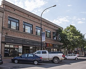
Chesbro Music Company
Distance: Approx. 1495 meters
Latitude and longitude: 43.49116667,-112.04072222
Chesbro Music Company is a privately owned American manufacturer and wholesaler of musical instruments, musical instrument accessories and sheet music. Chesbro Music was founded in 1911 and is based in Idaho Falls, Idaho. Chesbro owns Teton Guitars, and has been run by female CEOs since 1953.

Bonneville Hotel
United States historic place
Distance: Approx. 1690 meters
Latitude and longitude: 43.49472222,-112.03861111
The Bonneville Hotel, on the 400 block of W. C St. in Idaho Falls in Bonneville County, Idaho, was built in 1927. It was listed on the National Register of Historic Places in 1984.

Bonneville County Courthouse
United States historic place
Distance: Approx. 1564 meters
Latitude and longitude: 43.495,-112.04027778
The Bonneville County Courthouse is a historic building in Idaho Falls, Idaho, and the courthouse of Bonneville County, Idaho. It was built in 1921 with reinforced concrete, sandstone from Boise, and there is a marble staircase inside. The entrance includes "an entablature supported by Corinthian pilasters" and "a round arch with garlanded spandrels".

Douglas-Farr Building
United States historic place
Distance: Approx. 1543 meters
Latitude and longitude: 43.49388889,-112.04027778
The Douglas-Farr Building, at 493 N. Capital Ave. in Idaho Falls, Idaho, was built in 1911. It was listed on the National Register of Historic Places in 1984.
Rocky Mountain Bell Telephone Company Building (Idaho Falls, Idaho)
United States historic place
Distance: Approx. 1642 meters
Latitude and longitude: 43.49138889,-112.03888889
The Rocky Mountain Bell Telephone Company Building in Idaho Falls, Idaho, at 246 W. Broadway Ave., was built in 1910. It was listed on the National Register of Historic Places in 1984. It was a two-story commercial building, built of yellow brick with pinkish-gray stone trim, upon a stone foundation.

Mountain America Center
Arena in Idaho Falls, Idaho, United States
Distance: Approx. 1305 meters
Latitude and longitude: 43.481179,-112.065422
Mountain American Center is a multi-purpose arena and convention center in Idaho Falls, Idaho. It opened to the public on November 28, 2022.
Weather in this IP's area
clear sky
17 Celsius
15 Celsius
16 Celsius
18 Celsius
1020 hPa
33 %
1020 hPa
863 hPa
10000 meters
1.34 m/s
1.34 m/s
221 degree
07:30:50
19:01:50