74.51.99.245 - IP Lookup: Free IP Address Lookup, Postal Code Lookup, IP Location Lookup, IP ASN, Public IP
Country:
Region:
City:
Location:
Time Zone:
Postal Code:
IP information under different IP Channel
ip-api
Country
Region
City
ASN
Time Zone
ISP
Blacklist
Proxy
Latitude
Longitude
Postal
Route
Luminati
Country
Region
ga
City
lincolnton
ASN
Time Zone
America/New_York
ISP
API-DIGITAL
Latitude
Longitude
Postal
IPinfo
Country
Region
City
ASN
Time Zone
ISP
Blacklist
Proxy
Latitude
Longitude
Postal
Route
IP2Location
74.51.99.245Country
Region
alabama
City
capshaw
Time Zone
America/Chicago
ISP
Language
User-Agent
Latitude
Longitude
Postal
db-ip
Country
Region
City
ASN
Time Zone
ISP
Blacklist
Proxy
Latitude
Longitude
Postal
Route
ipdata
Country
Region
City
ASN
Time Zone
ISP
Blacklist
Proxy
Latitude
Longitude
Postal
Route
Popular places and events near this IP address

Harvest, Alabama
Census-designated place in Alabama, United States
Distance: Approx. 6150 meters
Latitude and longitude: 34.85277778,-86.74777778
Harvest is an unincorporated community and census-designated place (CDP) in the northwestern part of Madison County, Alabama, United States, and is included in the Huntsville-Decatur Combined Statistical Area. According to the 2020 U.S. Census, the population of the community is 5,893.
Alabama's 5th congressional district
U.S. House district for Alabama
Distance: Approx. 3108 meters
Latitude and longitude: 34.77771667,-86.78100556
Alabama's 5th congressional district is a U.S. congressional district in Alabama, which elects a representative to the United States House of Representatives. It encompasses the counties of Lauderdale, Limestone, Madison, Morgan and most of Jackson. It is currently represented by Republican Dale Strong, a former Madison County Commissioner.

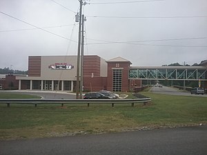
Sparkman High School
Public school in Harvest, Alabama, United States
Distance: Approx. 6875 meters
Latitude and longitude: 34.834,-86.716
Sparkman High School is a public high school in Harvest, Alabama, United States in the Madison County Schools district. The school was named after senator and former vice presidential nominee John Jackson Sparkman. Sparkman is one of the largest high schools in northern Alabama and serves students in grades 10-12.
Capshaw Mountain
Mountain in Alabama, United States
Distance: Approx. 4349 meters
Latitude and longitude: 34.81888889,-86.73805556
Capshaw Mountain is a mountain located in Harvest, Alabama. Capshaw Mountain forms a watershed that provides the water supply for the community. It extends upwards about 800 feet above the general elevation in the area.

Ford's Chapel United Methodist Church
United Methodist Church in Harvest, Alabama
Distance: Approx. 6205 meters
Latitude and longitude: 34.8412,-86.7305539
Ford's Chapel United Methodist Church, or simply Ford's Chapel UMC, is a United Methodist church located in Harvest, Alabama, in the United States. It was founded in 1808 and is the first Methodist Church established in what is now the state of Alabama.
Monrovia, Alabama
Unincorporated community in Alabama, United States
Distance: Approx. 6653 meters
Latitude and longitude: 34.78638889,-86.71388889
Monrovia, also known as Vaughn Corners or Thompson Mill, is an unincorporated community in Madison County, Alabama, United States. It is bordered on the south by the city of Madison, on the southeast by the city of Huntsville, on the west by Limestone County and on the north by the community of Harvest.
Oakland (near Madison), Limestone County, Alabama
Unincorporated community in Alabama, United States
Distance: Approx. 8790 meters
Latitude and longitude: 34.72916667,-86.80694444
Oakland is an unincorporated community in Limestone County, Alabama, United States. It is in the eastern part of the county near Madison at the intersection of Huntsville Brownsferry Road (formerly known as County Road 24) and County Road 119, as opposed to Oakland, Limestone County, Alabama which is just west of Athens. Oakland is named after the Oakland Spring, and the Oakland Spring Branch which is west of the community.

Limestone Correctional Facility
Prison in Limestone County, Alabama
Distance: Approx. 2118 meters
Latitude and longitude: 34.81222,-86.80453
Limestone Correctional Facility is an Alabama Department of Corrections state prison for men located in Harvest, Limestone County, Alabama. Opened in October 1984 and with a capacity of 2086 prisoners, Limestone is the largest prison in the Alabama state system. This institution is classified as a maximum security correctional facility.
Rainbow, Alabama
Unincorporated community in Alabama, United States
Distance: Approx. 7277 meters
Latitude and longitude: 34.7525,-86.73638889
Rainbow is an unincorporated community in Madison County, Alabama, United States.
WHMZ-LP
Radio station in Madison, Alabama
Distance: Approx. 9382 meters
Latitude and longitude: 34.73388889,-86.72888889
WHMZ-LP (95.5 FM) was a licensed low-power radio station in Madison, Alabama. The station was owned by Madison County Citizens for Better Government. The station was granted a construction permit on February 20, 2014; the WHMZ-LP call sign was issued on March 20, 2014.
Rainbow Mountain (Alabama)
Mountain in Alabama, United States
Distance: Approx. 9291 meters
Latitude and longitude: 34.73473611,-86.72911667
Rainbow Mountain is a mountain in Madison county, Alabama. The mountain's name is derived from the name of Elisha Rainbolt, who settled on the mountain around 1810.
French Mill, Alabama
Unincorporated community in Alabama, United States
Distance: Approx. 7651 meters
Latitude and longitude: 34.79388889,-86.86527778
French Mill is an unincorporated community located in Limestone County. It is halfway between the cities of Madison and Athens. French Mill is within the Huntsville Metropolitan Area, and is considered an exurb of the city despite Huntsville being located just south of the community.
Weather in this IP's area
clear sky
-2 Celsius
-6 Celsius
-2 Celsius
-1 Celsius
1030 hPa
76 %
1030 hPa
1001 hPa
10000 meters
3.13 m/s
6.71 m/s
10 degree
1 %