Country:
 USA
USARegion:
City:
Latitude and Longitude:
Postal Code:
Time Zone:
language:
User-Agent:
Proxy IP:
Blacklist:
IP information under different IP Channel
Luminati
74.239.82.153Country
USASN
Time Zone
America/Chicago
ISP
ATT-INTERNET4
Latitude
Longitude
Postal
Popular places and events near this IP address
Columbia, South Carolina
Capital city of South Carolina, United States
Distance: Approx. 37 meters
Latitude and longitude: 34.00055556,-81.03472222
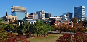
Columbia is the capital city of the U.S. state of South Carolina. With a population of 136,632 at the 2020 census, it is the second-most populous city in South Carolina. The city serves as the county seat of Richland County, and a portion of the city extends into neighboring Lexington County.
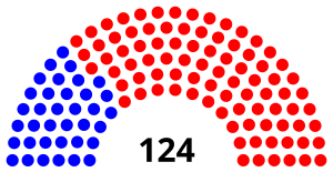
South Carolina House of Representatives
Lower house of the General Assembly of the U.S. state of South Carolina
Distance: Approx. 189 meters
Latitude and longitude: 34.00027778,-81.03305556
The South Carolina House of Representatives is the lower house of the South Carolina General Assembly. It consists of 124 representatives elected to two-year terms at the same time as U.S. congressional elections. Unlike many legislatures, seating on the floor is not divided by party, but is arranged by county delegation – a legacy of the original apportionment of the chamber.

South Carolina State House
State capitol building of the U.S. state of South Carolina
Distance: Approx. 176 meters
Latitude and longitude: 34.00043333,-81.03314722
The South Carolina State House is the building housing the government of the U.S. state of South Carolina, which includes the South Carolina General Assembly and the offices of the Governor and Lieutenant Governor of South Carolina. Located in the capital city of Columbia near the corner of Gervais and Assembly Streets, the building also housed the Supreme Court until 1971. The State House is in the Classical Revival style; it is approximately 180 feet (55 m) tall, 300 feet (91 m) long, 100 feet (30 m) wide.
WARQ
Radio station in Columbia, South Carolina
Distance: Approx. 22 meters
Latitude and longitude: 34.001,-81.035
WARQ (93.5 FM) is a commercial radio station in Columbia, South Carolina. It is owned by Alpha Media and it airs a Top 40 (CHR) format branded as "Live 93.5" Its studios are on Pineview Road in Columbia, off U.S. Route 378. WARQ is licensed by the Federal Communications Commission (FCC) to broadcast with an effective radiated power (ERP) of 2,800 watts.
WUDE
Radio station in Forest Acres, South Carolina
Distance: Approx. 22 meters
Latitude and longitude: 34.001,-81.035
WUDE (94.3 MHz) is a commercial FM radio station licensed to Forest Acres, South Carolina, and serving the Columbia metropolitan area. Owned by Midlands Media Group LLC, the station broadcasts a country music radio format branded as 94.3 The Dude. It concentrates on country hits from the 1980s till today.
Downtown Columbia, South Carolina
Central district of Columbia, South Carolina, United States
Distance: Approx. 37 meters
Latitude and longitude: 34.00055556,-81.03472222
Downtown Columbia is the downtown area of Columbia, South Carolina, United States. It contains the city's central business district and the State House. It also encompasses the University of South Carolina.

South Carolina State Armory
United States historic place
Distance: Approx. 121 meters
Latitude and longitude: 34.0015,-81.036
The South Carolina State Armory, built in 1905, is an historic National Guard building located at 1219 Assembly Street near the State House in Columbia, South Carolina.
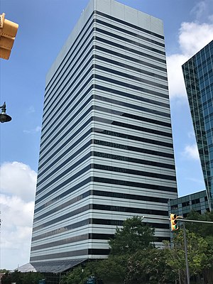
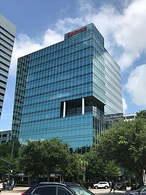
Capitol Center (Columbia, South Carolina)
Office skyscraper in Columbia, South Carolina
Distance: Approx. 43 meters
Latitude and longitude: 34.00111111,-81.03472222
Capitol Center is an office skyscraper in Columbia, South Carolina. At 106.4 m (349 ft), it is the tallest building in South Carolina. The tower has about 1,000 people inside working every week and about 400 offices.
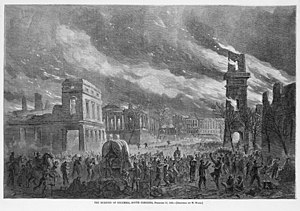
Capture of Columbia
1865 American Civil War battle
Distance: Approx. 22 meters
Latitude and longitude: 34.0007,-81.0348
The capture of Columbia occurred February 17–18, 1865, during the Carolinas Campaign of the American Civil War. The state capital of Columbia, South Carolina, was captured by Union forces under Maj. Gen.
Main and Gervais
Office building in Columbia, South Carolina
Distance: Approx. 122 meters
Latitude and longitude: 34.0016,-81.0341
The Tower at Main and Gervais is a high-rise office building in Columbia, South Carolina. Built in 2009, the tower has light blue glazing and is adorned with columns, giving the building a modern, stylized look. There is also an outdoor dining plaza at the base of the building between its ground and Gervais Street, looking towards the South Carolina State House.
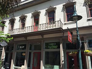
Building at 1210–1214 Main Street
United States historic place
Distance: Approx. 185 meters
Latitude and longitude: 34.0019,-81.0335
Building at 1210–1214 Main Street, also known as Capitol Café, is a historic commercial building located at Columbia, South Carolina. It was built by 1871, and is a two-story, seven-bay, stuccoed brick building. A cast-iron railing extends across central three bays of the second floor.
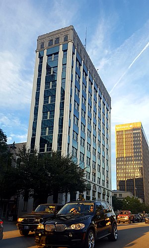
Union National Bank Building (Columbia, South Carolina)
United States historic place
Distance: Approx. 167 meters
Latitude and longitude: 34.00138889,-81.03333333
The Union National Bank Building is an historic building located in downtown Columbia, South Carolina, United States. The ten story Late Gothic Revival and Sullivanesque structure was completed in 1913. It was designed by Atlanta architect William Augustus Edwards.
Weather in this IP's area
mist
22 Celsius
23 Celsius
21 Celsius
23 Celsius
1009 hPa
93 %
8047 meters
3.09 m/s
180 degree
100 %
17:00:00
07:00:00
The latest IP detection test
- 237.215.126.81
- 47.88.110.63
- 89.66.71.1
- 83.231.100.125
- 37.228.1.241
- 66.207.23.83
- 5.6.89.41
- 119.206.94.239
- 246.160.94.185
- 62.87.81.253