Country:
 USA
USARegion:
City:
Latitude and Longitude:
Time Zone:
Postal Code:
IP information under different IP Channel
ip-api
Country
Region
City
ASN
Time Zone
ISP
Blacklist
Proxy
Latitude
Longitude
Postal
Route
IPinfo
Country
Region
City
ASN
Time Zone
ISP
Blacklist
Proxy
Latitude
Longitude
Postal
Route
MaxMind
Country
Region
City
ASN
Time Zone
ISP
Blacklist
Proxy
Latitude
Longitude
Postal
Route
Luminati
Country
USRegion
sd
City
aberdeen
ASN
Time Zone
America/Chicago
ISP
N-V-C
Latitude
Longitude
Postal
db-ip
Country
Region
City
ASN
Time Zone
ISP
Blacklist
Proxy
Latitude
Longitude
Postal
Route
ipdata
Country
Region
City
ASN
Time Zone
ISP
Blacklist
Proxy
Latitude
Longitude
Postal
Route
Popular places and events near this IP address

Aberdeen, South Dakota
City in South Dakota, United States
Distance: Approx. 1123 meters
Latitude and longitude: 45.46472222,-98.46861111
Aberdeen (Lakota: Ablíla) is a city in and the county seat of Brown County, South Dakota, United States, located approximately 125 miles (201 km) northeast of Pierre. The population was 28,495 at the 2020 census, making it the third-most populous city in the state. Aberdeen is home of Northern State University.

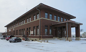
United States District Court for the District of South Dakota
United States federal district court of South Dakota
Distance: Approx. 382 meters
Latitude and longitude: 45.460896,-98.485908
The United States District Court for the District of South Dakota (in case citations, D.S.D.) is the United States District Court or the Federal district court, whose jurisdiction for issues pertaining to federal law or diversity for the state of South Dakota. The court is based in Sioux Falls with other courthouses in Rapid City, Pierre, and Aberdeen. The district was created in 1889, when the Dakota Territory was divided into North and South Dakota.

Northern State University
Public university in Aberdeen, South Dakota, US
Distance: Approx. 1353 meters
Latitude and longitude: 45.451461,-98.483634
Northern State University (NSU) is a public university in Aberdeen, South Dakota, United States. NSU is governed by the South Dakota Board of Regents and offers 45 bachelor's degrees, 53 minors, six associate degrees, 16 pre-professional programs, 23 certificates and 10 graduate degrees.
Aberdeen station (Milwaukee Road)
Distance: Approx. 536 meters
Latitude and longitude: 45.46555556,-98.48916667
The Chicago, Milwaukee, St. Paul and Pacific Railroad Depot in Aberdeen, South Dakota was built by the Chicago, Milwaukee, St. Paul and Pacific Railroad (also known as The Milwaukee Road) in 1911.
Aberdeen Historic District (Aberdeen, South Dakota)
Historic district in South Dakota, United States
Distance: Approx. 347 meters
Latitude and longitude: 45.46055556,-98.48194444
Aberdeen Historic District in Aberdeen, South Dakota is a 29-acre (12 ha) historic district that was listed on the National Register of Historic Places in 1975. It includes three whole blocks and 13 partial blocks. It includes part of Hagerty and Lloyd Historic District.

Masonic Temple (Aberdeen, South Dakota)
United States historic place
Distance: Approx. 562 meters
Latitude and longitude: 45.45972222,-98.4875
The Masonic Temple in Aberdeen, South Dakota is a building from 1899. It was listed on the National Register of Historic Places in 1980. It is a three-story building reflecting Italian Villa, Moorish, and Romanesque Revival styles.

United States Post Office and Courthouse–Aberdeen
United States historic place
Distance: Approx. 378 meters
Latitude and longitude: 45.46088,-98.485791
The U.S. Post Office and Courthouse-Aberdeen, in Aberdeen, South Dakota, was built in 1936 with Art Deco features. It is a steel-framed four-story rectangular building, 67 feet (20 m) tall on a 150 feet (46 m) by 64 feet (20 m) base, with a one-story 100 feet (30 m) by 64 feet (20 m) extension (part of the original). It was listed on the National Register of Historic Places in 2006.

First United Methodist Church (Aberdeen, South Dakota)
Historic church in South Dakota, United States
Distance: Approx. 497 meters
Latitude and longitude: 45.46,-98.48666667
Aberdeen First United Methodist Church is a historic church at S. Lincoln Street and SE 5th Avenue in Aberdeen, South Dakota. The church was built during 1904-05 and dedicated November 7, 1909. It was added to the National Register in 1976.

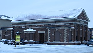
Aberdeen station (South Dakota)
Distance: Approx. 242 meters
Latitude and longitude: 45.465,-98.48527778
Aberdeen station, also known as the Burlington Northern Depot, is a historic Burlington Northern train station at 1 Court Street in Aberdeen, South Dakota. It was built in 1906, designed by architect Samuel L. Bartlett, and was added to the National Register of Historic Places in 1983 as the Great Northern Railway Passenger and Freight Depot.

Brown County Courthouse (South Dakota)
United States historic place
Distance: Approx. 310 meters
Latitude and longitude: 45.4646,-98.4866
The Brown County Courthouse is a historic courthouse in Aberdeen, the county seat of Brown County, South Dakota. It was built in 1904 and is listed on the National Register of Historic Places.

Alonzo Ward Hotel
United States historic place
Distance: Approx. 432 meters
Latitude and longitude: 45.464,-98.4884
The Alonzo Ward Hotel is a historic hotel in Aberdeen, South Dakota. It is individually listed on the National Register of Historic Places and is a contributing property to the Aberdeen Commercial Historic District.
Aberdeen station (Minneapolis and St. Louis Railway)
Distance: Approx. 1154 meters
Latitude and longitude: 45.45388889,-98.48805556
Aberdeen station, otherwise known as the Minneapolis and St. Louis Railroad Depot in Aberdeen, South Dakota was built by the Minneapolis and St. Louis Railway (or M&StL) in the early 1900s and opened for service on September 1, 1907.
Weather in this IP's area
few clouds
12 Celsius
11 Celsius
12 Celsius
13 Celsius
1016 hPa
76 %
1016 hPa
970 hPa
10000 meters
6.17 m/s
40 degree
20 %
07:54:40
18:42:56