Country:
 USA
USARegion:
City:
Latitude and Longitude:
Time Zone:
Postal Code:
IP information under different IP Channel
ip-api
Country
Region
City
ASN
Time Zone
ISP
Blacklist
Proxy
Latitude
Longitude
Postal
Route
IPinfo
Country
Region
City
ASN
Time Zone
ISP
Blacklist
Proxy
Latitude
Longitude
Postal
Route
MaxMind
Country
Region
City
ASN
Time Zone
ISP
Blacklist
Proxy
Latitude
Longitude
Postal
Route
Luminati
Country
USASN
Time Zone
America/Chicago
ISP
INTERNAP-BLK3
Latitude
Longitude
Postal
db-ip
Country
Region
City
ASN
Time Zone
ISP
Blacklist
Proxy
Latitude
Longitude
Postal
Route
ipdata
Country
Region
City
ASN
Time Zone
ISP
Blacklist
Proxy
Latitude
Longitude
Postal
Route
Popular places and events near this IP address

Secaucus, New Jersey
Town in Hudson County, New Jersey, US
Distance: Approx. 634 meters
Latitude and longitude: 40.781958,-74.067649
Secaucus ( SEE-kaw-kəs) is a town in Hudson County, in the U.S. state of New Jersey. As of the 2020 United States census, the town's population was 22,181, an increase of 5,917 (+36.4%) from the 2010 census count of 16,264, which in turn reflected an increase of 333 (+2.1%) from the 15,931 counted in the 2000 census. Located within the New Jersey Meadowlands, it is the most suburban of the county's municipalities, though large parts of the town are dedicated to light manufacturing, retail, and transportation uses, as well as protected areas.
Secaucus Junction
NJ Transit and Metro-North Railroad station
Distance: Approx. 1766 meters
Latitude and longitude: 40.76127917,-74.07569112
Secaucus Junction (signed as Secaucus) is an intermodal transit hub served by New Jersey Transit (NJ Transit) and Metro-North Railroad in Secaucus, New Jersey. It is one of the busiest railway stations in North America. The $450 million, 321,000-square-foot (29,800 m2) station opened on December 15, 2003.

Berry's Creek
River known for its pollution in northeastern New Jersey, United States
Distance: Approx. 1706 meters
Latitude and longitude: 40.7867,-74.0849
Berry's Creek (sometimes referred to as Berrys Creek or Berry Creek) is a tributary of the Hackensack River in the New Jersey Meadowlands in Bergen County, New Jersey. The creek watershed contains a diverse array of wetlands, marshes, and wildlife. The creek runs through a densely populated region and has been subject to extensive industrial pollution during the 19th and 20th centuries.

WEPN (AM)
ESPN Radio station in New York City
Distance: Approx. 1517 meters
Latitude and longitude: 40.77676944,-74.05180833
WEPN (1050 kHz) is a sports radio station licensed to New York, New York. The station is owned-and-operated by Good Karma Brands and its transmitter site is located in North Bergen, New Jersey. The 1050 AM facility in New York signed on in 1922 as WHN. For the majority of its existence under these call letters, as well as during its 14-year stint as WMGM, the station broadcast several different music-based formats, finally assuming a country music format in 1973.

Hudson County Burial Grounds
Cemetery in New Jersey
Distance: Approx. 1714 meters
Latitude and longitude: 40.76161,-74.074985
The Hudson County Burial Grounds, also known as the Secaucus Potter's Field and Snake Hill Cemetery, is located in Secaucus, New Jersey. The cemetery was cleared of bodies to make room for the Secaucus Transfer Station and Exit 15X of the New Jersey Turnpike between 1992-2003. More than 4,000 bodies were disinterred.

Secaucus Public Schools
School district in Hudson County, New Jersey, US
Distance: Approx. 1807 meters
Latitude and longitude: 40.788239,-74.054993
The Secaucus Public Schools is a public school district that serves students in pre-kindergarten through twelfth grade from Secaucus, in Hudson County, in the U.S. state of New Jersey. As of the 2020–21 school year, the district, comprising four schools, had an enrollment of 2,229 students and 187.5 classroom teachers (on an FTE basis), for a student–teacher ratio of 11.9:1. The district is classified by the New Jersey Department of Education as being in District Factor Group "DE", the fifth-highest of eight groupings.
Upper Hack Lift
Bridge in Secaucus and Lyndhurst, New Jersey
Distance: Approx. 1703 meters
Latitude and longitude: 40.778015,-74.089906
Upper Hack Lift is a lift bridge carrying the New Jersey Transit Main Line across the Hackensack River at mile 6.9 between Secaucus, New Jersey and Lyndhurst.

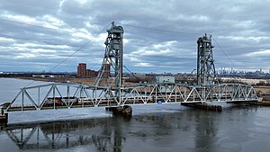
HX Draw
Bridge in Secaucus and East Rutherford, New Jersey
Distance: Approx. 1642 meters
Latitude and longitude: 40.788078,-74.081869
The HX Draw is a bascule bridge carrying the New Jersey Transit Bergen County Line and Pascack Valley Line across the Hackensack River between Secaucus, New Jersey and East Rutherford. The bridge is also known as The Jack-Knife because of its unusual method of opening. Designed by Joseph Strauss and completed in 1911, this bridge is one of the first heel trunnion bascule bridges built in the United States and originally formed part of the Erie Railroad's main line.

Abel I. Smith Burial Ground
Distance: Approx. 627 meters
Latitude and longitude: 40.777984,-74.062622
The Abel I. Smith Burial Ground (also spelled Able I. Smith Burial Ground) was a family burial plot in Hudson County, New Jersey, United States.

Harmon Cove station
Abandoned train station in New Jersey, US
Distance: Approx. 942 meters
Latitude and longitude: 40.7813,-74.079
Harmon Cove is an abandoned train station in the Harmon Cove section of Secaucus, New Jersey. The station was a former stop on the Bergen County Line which runs from Hoboken Terminal to Suffern. Train service was discontinued in 2003 when Secaucus Junction was opened.
Meadowview Psychiatric Hospital
Hospital in New Jersey, United States
Distance: Approx. 1183 meters
Latitude and longitude: 40.7831,-74.0588
Meadowview Psychiatric Hospital is a hospital in Secaucus, New Jersey. Founded as the Hudson County Hospital for the Insane 1864, the hospital was originally located on Snake Hill. In 1927 its patients were moved to a new facility on County Avenue (where Meadowview Hospital is now located) and its name was changed to Hudson County Hospital Mental Diseases.

Hudson Regional Hospital
Distance: Approx. 1729 meters
Latitude and longitude: 40.7918,-74.0733
Hudson Regional Hospital (HRH) is an acute care hospital, located on the Hackensack River, in Secaucus, New Jersey, on Meadowlands Parkway near Route 3. HRH has a helipad for transporting injured persons from the scene of an accident to the hospital and/or for transferring patients in critical need of specialized services from HRH to another hospital having that capability.
Weather in this IP's area
few clouds
22 Celsius
22 Celsius
21 Celsius
23 Celsius
1009 hPa
60 %
1009 hPa
1008 hPa
10000 meters
4.63 m/s
310 degree
20 %
06:59:18
18:28:20