Country:
 USA
USARegion:
City:
Latitude and Longitude:
Time Zone:
Postal Code:
IP information under different IP Channel
ip-api
Country
Region
City
ASN
Time Zone
ISP
Blacklist
Proxy
Latitude
Longitude
Postal
Route
IPinfo
Country
Region
City
ASN
Time Zone
ISP
Blacklist
Proxy
Latitude
Longitude
Postal
Route
MaxMind
Country
Region
City
ASN
Time Zone
ISP
Blacklist
Proxy
Latitude
Longitude
Postal
Route
Luminati
Country
USASN
Time Zone
America/Chicago
ISP
BWINPARTY-US-01
Latitude
Longitude
Postal
db-ip
Country
Region
City
ASN
Time Zone
ISP
Blacklist
Proxy
Latitude
Longitude
Postal
Route
ipdata
Country
Region
City
ASN
Time Zone
ISP
Blacklist
Proxy
Latitude
Longitude
Postal
Route
Popular places and events near this IP address

Scudder Falls Bridge
Bridge in Mercer County, New Jersey
Distance: Approx. 2605 meters
Latitude and longitude: 40.25861111,-74.84722222
The Scudder Falls Bridge is a toll bridge that carries Interstate 295 (I-295) over the Delaware River, connecting Lower Makefield Township in Bucks County, Pennsylvania, with the Scudders Falls section of Ewing Township in Mercer County, New Jersey, United States. It is maintained by the Delaware River Joint Toll Bridge Commission (DRJTBC). The original bridge was a plate girder bridge constructed from 1958 to 1961, and the current structure is a box-girder bridge that partially opened in 2019 and was substantially complete in 2021.
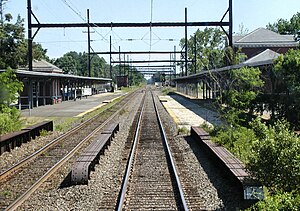
West Trenton station
SEPTA Regional Rail station in Ewing Township, New Jersey
Distance: Approx. 2562 meters
Latitude and longitude: 40.25722222,-74.81527778
West Trenton station is the northern terminus of SEPTA's West Trenton Line. It is located at Grand and Railroad Avenues in the West Trenton section of Ewing Township, New Jersey, however this address only applies to the southbound station house on the west side of the tracks. The northbound station house is on the east side of the tracks and is located on Sullivan Way, which changes into Grand Avenue once it crosses under the tracks.

West Trenton, New Jersey
Populated place in Mercer County, New Jersey, US
Distance: Approx. 1776 meters
Latitude and longitude: 40.26388889,-74.81861111
West Trenton is an unincorporated community within Ewing Township in Mercer County, New Jersey, United States. It is a suburban area located adjacent to the northwestern portion of the city of Trenton, from which it derives its name. Located at the intersection of Bear Tavern Road/Grand Avenue and West Upper Ferry Road, it is one of the oldest settlements in Ewing Township.
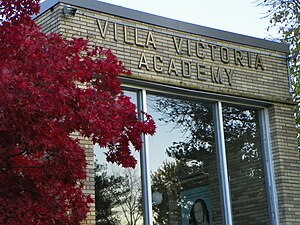
Villa Victoria Academy
Catholic high school in Mercer County, New Jersey, United States
Distance: Approx. 2669 meters
Latitude and longitude: 40.25555556,-74.84166667
Villa Victoria Academy is an all-girls, private, Catholic middle and high school located in the West Trenton section of Ewing Township, New Jersey. It is located in the Roman Catholic Diocese of Trenton. The school has been accredited by the Middle States Association of Colleges and Schools Commission on Elementary and Secondary Schools since 1996; Middle States accreditation of the school expires on January 1, 2029.
Inland Fisher Guide Plant (New Jersey)
GM factory in Ewing Township, New Jersey, US
Distance: Approx. 2211 meters
Latitude and longitude: 40.2647,-74.8095
The Inland Fisher Guide Plant was a General Motors facility located in the West Trenton section of Ewing Township, New Jersey, that opened in 1938 as one of its most modern plants and was operated by the firm for 60 years. The facility was initially part of the Ternstedt division of GM's Fisher Body unit and was used to construct auto parts such as body moldings, door handles and other interior components. During World War II, the facility was converted to build torpedo bombers for the United States Navy as part of GM's Eastern Aircraft.

Trenton–Mercer Airport
Airport in Ewing Township, New Jersey, US
Distance: Approx. 1360 meters
Latitude and longitude: 40.27666667,-74.81333333
Trenton–Mercer Airport (IATA: TTN, ICAO: KTTN, FAA LID: TTN) is a county-owned, joint civil–military, public airport located four miles northwest of Trenton in the West Trenton section of Ewing Township, Mercer County, New Jersey. Formerly known as Mercer County Airport, the airport serves one scheduled airline plus general and corporate aviation. The U.S. Department of Transportation reports that approximately 301,000 passengers arrived and 300,000 departed at the airport in the 12 months ending July 2023, for a total of 601,000 passengers.
Ewing (unincorporated community), New Jersey
Populated place in Mercer County, New Jersey, US
Distance: Approx. 2639 meters
Latitude and longitude: 40.26972222,-74.8
Ewing is a section of Ewing Township in Mercer County, in the U.S. state of New Jersey. Located at the intersection of Upper Ferry Road and Scotch Road, it is one of the oldest settlements in Ewing Township and dates back to the 18th century. The community was known as Carleton before adopting its current name.

Somerset Roller Mills
United States historic place
Distance: Approx. 2062 meters
Latitude and longitude: 40.27880556,-74.85352778
The Somerset Roller Mills, also known as the Jacobs Creek Grist Mill, are a small former gristmill complex, originally built in the early 18th century, near Titusville in Hopewell Township of Mercer County, New Jersey. It was added to the National Register of Historic Places on November 19, 1974 for its significance in architecture, commerce, and industry.

Bear Tavern Road–Jacob's Creek Crossing Rural Historic District
Historic district in New Jersey, United States
Distance: Approx. 2784 meters
Latitude and longitude: 40.29838889,-74.84752778
The Bear Tavern Road–Jacob's Creek Crossing Rural Historic District covers the farms along Bear Tavern Road north of its intersection with Jacob's Creek Road, as well as the bridge and intersection itself. Bear Tavern Road dates to 1729 and George Washington led the Continental Army along it in 1776, on his way from crossing the Delaware to the Battle of Trenton. The district still reflects its 18th and 19th century patterns of development.

Green–Reading House
United States historic place
Distance: Approx. 1962 meters
Latitude and longitude: 40.26022222,-74.82541667
The Green–Reading House is a historic late 18th-century Federal style farmhouse in Ewing Township, New Jersey. The Green family was notable for running the Delaware River Ferry, which crossed the river at the foot of Wilburtha Road. The house later came into the Reading family by marriage.
Dyers Creek
River in Pennsylvania, United States
Distance: Approx. 2455 meters
Latitude and longitude: 40.2675,-74.855
Dyers Creek is a tributary of the Delaware River wholly contained within Lower Makefield Township, Bucks County, Pennsylvania.

Jacobs Creek (New Jersey)
River in New Jersey, United States
Distance: Approx. 2150 meters
Latitude and longitude: 40.27788611,-74.85460833
Jacobs Creek is a tributary of the Delaware River in Mercer County in the U.S. state of New Jersey. From its headwaters in Hopewell Township, the creek flows generally south and southwest. Along the creek's lower course, it flows along the border between Hopewell Township and Ewing Township, entering the Delaware River between Lambertville and Trenton.
Weather in this IP's area
scattered clouds
20 Celsius
20 Celsius
19 Celsius
21 Celsius
1010 hPa
79 %
1010 hPa
1003 hPa
10000 meters
4.63 m/s
290 degree
40 %
07:02:01
18:31:41