Country:
 USA
USARegion:
City:
Latitude and Longitude:
Time Zone:
Postal Code:
IP information under different IP Channel
ip-api
Country
Region
City
ASN
Time Zone
ISP
Blacklist
Proxy
Latitude
Longitude
Postal
Route
IPinfo
Country
Region
City
ASN
Time Zone
ISP
Blacklist
Proxy
Latitude
Longitude
Postal
Route
MaxMind
Country
Region
City
ASN
Time Zone
ISP
Blacklist
Proxy
Latitude
Longitude
Postal
Route
Luminati
Country
USASN
Time Zone
America/Chicago
ISP
INTERNAP-2BLK
Latitude
Longitude
Postal
db-ip
Country
Region
City
ASN
Time Zone
ISP
Blacklist
Proxy
Latitude
Longitude
Postal
Route
ipdata
Country
Region
City
ASN
Time Zone
ISP
Blacklist
Proxy
Latitude
Longitude
Postal
Route
Popular places and events near this IP address
Hour of Power
American Evangelist television program
Distance: Approx. 2149 meters
Latitude and longitude: 33.67703,-117.80566
Hour of Power is a weekly American Evangelist television program broadcast from Shepherd's Grove Presbyterian Church in Irvine, California, near Los Angeles. It was formerly one of the most watched religious broadcasts in the world, seen by approximately two million viewers at its peak. It was formerly broadcast from the Crystal Cathedral in Garden Grove, California.
Pao Fa Temple
Buddhist monastery and temple in California
Distance: Approx. 865 meters
Latitude and longitude: 33.69204,-117.82969
Pao Fa Temple (Chinese: 寶法寺; pinyin: Bǎofǎ Sì; Pe̍h-ōe-jī: Pó-hoat-sī) is one of the largest Buddhist monasteries and Buddhist temples in the United States. It is located in Irvine, California. It mainly attracts Taiwanese American, Chinese American and Vietnamese American Buddhists, including many who are students at the University of California, Irvine.

Woodbridge High School (Irvine, California)
Public high school in Irvine, California
Distance: Approx. 2000 meters
Latitude and longitude: 33.6784,-117.80674
Woodbridge High School (WHS) is a public high school located in Irvine, California, United States, serving grades 9–12. Woodbridge is in the Irvine Unified School District. Founded in 1980, it has an approximate enrollment of 2,400 students.
Tustin Legacy, Tustin, California
Planned community in Tustin, California, United States
Distance: Approx. 2226 meters
Latitude and longitude: 33.70224532,-117.81568193
Tustin Legacy is a 1,600-acre (6.5 km2) planned community in Tustin, California being developed on the former Marine Corps Air Station Tustin. The project, under construction, will include parks, a commercial retail center and various densities of housing, for a total of 4,600 units. The district includes 4,049 units of housing within Tustin's jurisdiction, and over nine million square feet of commercial and institutional development.
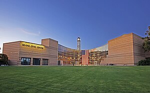
Irvine, California
City in California, United States
Distance: Approx. 1726 meters
Latitude and longitude: 33.66944444,-117.82305556
Irvine () is the largest city and a master-planned city in central Orange County, California, United States, in the Los Angeles metropolitan area. The Irvine Company started developing the area in the 1960s and the city was formally incorporated on December 28, 1971. The 66-square-mile (170 km2) city had a population of 307,670 at the 2020 census; it is the 63rd most populous city in the United States.

Irvine Police Department
Police department for the city of Irvine, California
Distance: Approx. 187 meters
Latitude and longitude: 33.68614462,-117.82619654
The Irvine Police Department is the local law enforcement agency of the city of Irvine, California, United States. The department's jurisdiction includes the entire city of Irvine, which covers nearly 70 square miles (180 km2) and a population of over 270,000, as well as the Orange County Great Park. It also supplements the jurisdiction of the University of California, Irvine, Police Department, whose jurisdiction includes the University of California, Irvine campus and surrounding areas of the city.

Rancho San Joaquin
Mexican land grant in California
Distance: Approx. 884 meters
Latitude and longitude: 33.69,-117.82
Rancho San Joaquin, the combined Rancho Cienega de las Ranas and Rancho Bolsa de San Joaquin, was a 48,803-acre (197.50 km2) Mexican land grant in the San Joaquin Hills, within present-day Orange County, California. It was granted to José Antonio Andres Sepúlveda. In Spanish Cienega de las Ranas means "Marsh of the Frogs" and Bolsa means "Pocket", and usually in reference to wetlands landforms.
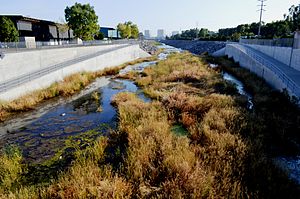
Peters Canyon Wash
Stream in Orange County, California
Distance: Approx. 1270 meters
Latitude and longitude: 33.69399615,-117.81922743
Peters Canyon Wash is a tributary of San Diego Creek in central Orange County in the U.S. state of California.

Shepherd's Grove
Church in California, United States
Distance: Approx. 2125 meters
Latitude and longitude: 33.677155,-117.805878
Shepherd's Grove is a congregation of the Presbyterian Church (USA) in Irvine, California, United States. The church was founded by Robert H. Schuller in 1955 as the Garden Grove Community Church and renamed to Crystal Cathedral Ministries after its church building, the Crystal Cathedral, in 1981. The congregation is now pastored by Bobby V. Schuller, grandson of Robert H. Schuller, and the organization has changed its name to Shepherd's Grove Ministries.
Alphaeon Corporation
American healthcare company
Distance: Approx. 2463 meters
Latitude and longitude: 33.67833333,-117.8525
Alphaeon Corporation is a company focused on healthcare products and services based in Irvine, California. Alphaeon Corporation serves healthcare providers in the self-pay segment; primarily plastic surgery, ophthalmology, dentistry, and dermatology.

The District (Tustin)
Shopping mall in California, United States
Distance: Approx. 1458 meters
Latitude and longitude: 33.6977,-117.8268
The District is a large outdoor shopping center and entertainment hub in Tustin, California. It was developed by Vestar Development Co. and was the largest shopping center in Orange County to open in more than a decade when it opened in 2007.
Westcliff University
For-profit university in Irvine, California
Distance: Approx. 1948 meters
Latitude and longitude: 33.6855,-117.848
Westcliff University (WU) is a private, for-profit university in Irvine, California. Founded in 1993, it offers bachelor's, master's, and doctorate degrees, as well as certificate programs and continuing education courses.
Weather in this IP's area
scattered clouds
23 Celsius
23 Celsius
21 Celsius
25 Celsius
1011 hPa
61 %
1011 hPa
1009 hPa
10000 meters
3.13 m/s
3.58 m/s
225 degree
40 %
06:35:47
18:56:19