Country:
Region:
City:
Latitude and Longitude:
Time Zone:
Postal Code:
IP information under different IP Channel
ip-api
Country
Region
City
ASN
Time Zone
ISP
Blacklist
Proxy
Latitude
Longitude
Postal
Route
Luminati
Country
ASN
Time Zone
America/Chicago
ISP
INTERNAP-2BLK
Latitude
Longitude
Postal
IPinfo
Country
Region
City
ASN
Time Zone
ISP
Blacklist
Proxy
Latitude
Longitude
Postal
Route
db-ip
Country
Region
City
ASN
Time Zone
ISP
Blacklist
Proxy
Latitude
Longitude
Postal
Route
ipdata
Country
Region
City
ASN
Time Zone
ISP
Blacklist
Proxy
Latitude
Longitude
Postal
Route
Popular places and events near this IP address

Angel Stadium
Baseball park in Anaheim, California
Distance: Approx. 2285 meters
Latitude and longitude: 33.80027778,-117.88277778
Angel Stadium is a baseball stadium located in Anaheim, California, United States. Since its opening 58 years ago in 1966, it has been the home field of the Los Angeles Angels, a Major League Baseball team. It was also the home stadium of the Los Angeles Rams of the National Football League (NFL) from 1980 to 1994.

The Outlets at Orange
Shopping mall in Orange, California
Distance: Approx. 375 meters
Latitude and longitude: 33.782644,-117.893076
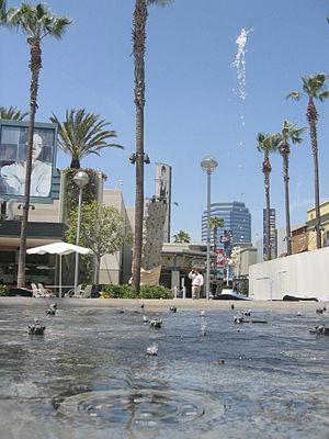
The Outlets at Orange (former names The Block at Orange and The City Shopping Center) is an open-air outlet mall in the city of Orange, California, in northern Orange County developed by The Mills Corporation and now owned by Simon Property Group. The anchor stores in this outlet are Dave & Buster's, Guitar Center, AMC Theatres, Neiman Marcus Last Call, Saks Fifth Avenue, Nordstrom Rack, Gap, and Bloomingdale's.

Orange Crush interchange
Interchange in California
Distance: Approx. 1690 meters
Latitude and longitude: 33.7801,-117.8792
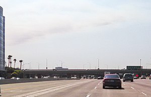
The Orange Crush interchange, frequently called The Crush, is a freeway interchange in the cities of Orange and Santa Ana, California, near the city limits of the cities of Anaheim, and Garden Grove. The Disneyland Resort, The Outlets at Orange, St. Joseph Hospital, Children's Hospital of Orange County, the UCI Medical Center, Westfield MainPlace, Angel Stadium of Anaheim, Honda Center, Platinum Triangle and the Lamaroux Justice Center of the Superior Court of California of the County of Orange are all located at or near the interchange.

Area codes 714 and 657
Area code covering areas of southern California
Distance: Approx. 1858 meters
Latitude and longitude: 33.8,-117.9
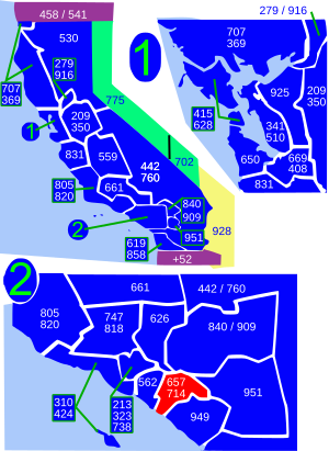
Area codes 714 and 657 are telephone area codes in the North American Numbering Plan for the southern part of the U.S. state of California. The numbering plan area comprises northern Orange County, a portion of Los Angeles County, and the Sleepy Hollow and Carbon Canyon areas of Chino Hills in San Bernardino County. Area code 714 was assigned to a part of numbering plan area 213 in 1951, and 657 was added in 2008 to form an overlay complex.

University of California, Irvine Medical Center
Hospital in California, United States
Distance: Approx. 916 meters
Latitude and longitude: 33.78781,-117.88857
The University of California, Irvine Medical Center (UCIMC or UCI Medical Center) is a major research hospital located in Orange, California. It is the teaching hospital for the University of California, Irvine School of Medicine.
KEBN
Radio station in Garden Grove, California, United States
Distance: Approx. 463 meters
Latitude and longitude: 33.781,-117.893
KEBN 94.3 FM, Garden Grove, California, KBUE 105.5 FM, Long Beach, California and KBUA 94.3 FM, San Fernando, California are a trimulcast comprising Que Buena 105.5/94.3 FM, a Spanish language regional Mexican music station owned by Estrella Media.

California's 47th congressional district
U.S. House district for California
Distance: Approx. 211 meters
Latitude and longitude: 33.783024,-117.899206
California's 47th congressional district is a congressional district in the U.S. state of California. Following the 2020 redistricting cycle, the district shifted to Orange County to contain Irvine, Huntington Beach, Costa Mesa, Newport Beach, and Seal Beach. It is currently represented by Democrat Katie Porter.
South Coast College
For-profit technical college in California
Distance: Approx. 2211 meters
Latitude and longitude: 33.7883835,-117.87383386
South Coast College is a private for-profit technical college in Orange, California. It offers certificates for career preparation in court reporting and medical assistant careers and a paralegal Associate of Arts degree. It is accredited by the Accrediting Commission of Career Schools and Colleges and approved by the Bureau for Private Postsecondary Education in the state of California, for court reporting, paralegal, and medical assistant programs.

Santiago Creek
River in California, United States
Distance: Approx. 1636 meters
Latitude and longitude: 33.76972222,-117.89083333
Santiago Creek is a major watercourse in Orange County in the U.S. state of California. About 34 miles (55 km) long, it drains most of the northern Santa Ana Mountains and is a tributary to the Santa Ana River. It is one of the longest watercourses entirely within the county.

Battle of the Dance
Distance: Approx. 1808 meters
Latitude and longitude: 33.79166667,-117.91388889
Battle of the Dance was a dinner theater in Anaheim, California, featuring contrasting styles of dance—principally flamenco and Irish folk dancing—performed by a cast of over 40 dancers. Designed to cash in on the popularity of such shows as Dancing with the Stars and So You Think You Can Dance, the venture was very ambitious: the brainchild of Medieval Times founder Andrés Gelabert, backed by $10 million in investor capital, and performing in a dedicated 40,000 square foot venue. Performances debuted to much fanfare in February 2011, and the show met with critical success: for example, the Orange County Register said, "Without a doubt...
Bristol University (California)
University in Anaheim, California, United States
Distance: Approx. 1888 meters
Latitude and longitude: 33.795556,-117.882647
Bristol University was a private university in Anaheim, California. It was established in 1991 as Kensington College. It became a university in 2011 and was renamed Bristol University.

Christ Cathedral (Garden Grove, California)
Church in the United States
Distance: Approx. 469 meters
Latitude and longitude: 33.787396,-117.898933
Christ Cathedral (Latin: Cathedralis Christi; Spanish: Catedral de Cristo; Vietnamese: Nhà Thờ Chính Tòa Chúa Kitô), formerly and informally known as the Crystal Cathedral, is an American church building and the cathedral of the Roman Catholic Diocese of Orange, located in Garden Grove, California. The reflective glass building, by the firm of Philip Johnson/John Burgee Architects, seats 2,248 people. The church was touted as "the largest glass building in the world" when it was completed in 1981.
Weather in this IP's area
mist
14 Celsius
14 Celsius
13 Celsius
16 Celsius
1011 hPa
91 %
1011 hPa
1007 hPa
10000 meters
1.54 m/s
210 degree
20 %
06:13:05
16:57:09