Country:
 USA
USARegion:
City:
Latitude and Longitude:
Time Zone:
Postal Code:
IP information under different IP Channel
ip-api
Country
Region
City
ASN
Time Zone
ISP
Blacklist
Proxy
Latitude
Longitude
Postal
Route
IPinfo
Country
Region
City
ASN
Time Zone
ISP
Blacklist
Proxy
Latitude
Longitude
Postal
Route
MaxMind
Country
Region
City
ASN
Time Zone
ISP
Blacklist
Proxy
Latitude
Longitude
Postal
Route
Luminati
Country
USASN
Time Zone
America/Chicago
ISP
INTERNAP-BLK3
Latitude
Longitude
Postal
db-ip
Country
Region
City
ASN
Time Zone
ISP
Blacklist
Proxy
Latitude
Longitude
Postal
Route
ipdata
Country
Region
City
ASN
Time Zone
ISP
Blacklist
Proxy
Latitude
Longitude
Postal
Route
Popular places and events near this IP address

Chicago Board of Trade
Options and futures exchange in Chicago
Distance: Approx. 14 meters
Latitude and longitude: 41.877821,-87.632285
The Chicago Board of Trade (CBOT), established on April 3, 1848, is one of the world's oldest futures and options exchanges. On July 12, 2007, the CBOT merged with the Chicago Mercantile Exchange (CME) to form CME Group. CBOT and three other exchanges (CME, NYMEX, and COMEX) now operate as designated contract markets (DCM) of the CME Group.

Federal Reserve Bank of Chicago
Member Bank of Federal Reserve
Distance: Approx. 106 meters
Latitude and longitude: 41.878484,-87.631567
The Federal Reserve Bank of Chicago (informally the Chicago Fed) is one of twelve Federal Reserve Banks that, along with the Federal Reserve Board of Governors, make up the Federal Reserve System, the United States' central bank. The Chicago Fed serves the Seventh District, which encompasses the northern portions of Illinois and Indiana, southern Wisconsin, the Lower Peninsula of Michigan, and the state of Iowa. In addition to participation in the formulation of monetary policy, each Reserve Bank supervises member banks and bank holding companies, provides financial services to depository institutions and the U.S. government, and monitors economic conditions in its District.

LaSalle Street
Major street in Chicago, Illinois, U.S.
Distance: Approx. 108 meters
Latitude and longitude: 41.87866667,-87.63225
LaSalle Street is a major north-south street in Chicago named for René-Robert Cavelier, Sieur de La Salle, a 17th century French explorer of the Illinois Country. The portion that runs through the Chicago Loop is considered to be Chicago's financial district.

Wells Street Terminal
Rail terminal in Chicago, 1904–1953
Distance: Approx. 124 meters
Latitude and longitude: 41.8777,-87.6338
Wells Street Terminal was a stub-end downtown terminal on the 'L' in Chicago, Illinois, located at Wells Street between Jackson Boulevard and Van Buren Street. The terminal was in operation from 1904 to 1953.

Rookery Building
Building in Chicago
Distance: Approx. 155 meters
Latitude and longitude: 41.87908333,-87.63211111
The Rookery Building is a historic office building located at 209 South LaSalle Street in the Chicago Loop. Completed by architects Daniel Burnham and John Wellborn Root of Burnham and Root in 1888, it is considered one of their masterpiece buildings, and was once the location of their offices. The building is 181 feet (55 m) in height, twelve stories tall, and is considered the oldest standing high-rise in Chicago.

LaSalle/Van Buren station
Chicago "L" station
Distance: Approx. 110 meters
Latitude and longitude: 41.8768,-87.631739
LaSalle/Van Buren is a Chicago "L" station in downtown Chicago serving the CTA's Brown, Orange, Pink, and Purple Lines. LaSalle/Van Buren is one of the eight stations in the Loop. The station opened on October 3, 1897.
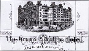
Grand Pacific Hotel (Chicago)
Hotel in Chicago, Illinois
Distance: Approx. 120 meters
Latitude and longitude: 41.8786,-87.6315
The Grand Pacific Hotel was one of the first two prominent hotels built in Chicago, Illinois, after the Great Chicago Fire. The hotel, designed by William W. Boyington and managed for more than 20 years by John Drake, was located on the block bounded by Clark Street, LaSalle, Quincy and Jackson. It was a replacement for the Pacific Hotel, which had been built in 1871 (also designed by Boyington), only to burn in the fire later that year.
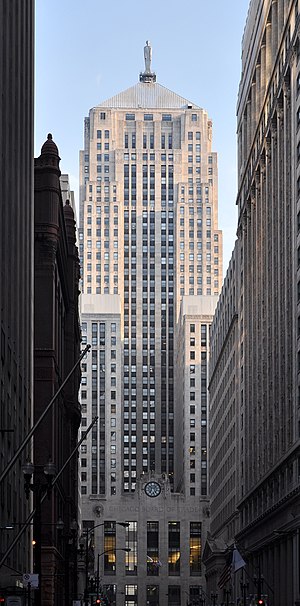
Chicago Board of Trade Building
Skyscraper in Chicago, Illinois
Distance: Approx. 40 meters
Latitude and longitude: 41.87805556,-87.63222222
The Chicago Board of Trade Building is a 44-story, 604-foot (184 m) Art Deco skyscraper located in the Chicago Loop, standing at the foot of the LaSalle Street canyon. Built in 1930 for the Chicago Board of Trade (CBOT), it has served as the primary trading venue of the CBOT and later the CME Group, formed in 2007 by the merger of the CBOT and the Chicago Mercantile Exchange. In 2012, the CME Group sold the CBOT Building to a consortium of real estate investors, including GlenStar Properties LLC and USAA Real Estate Company.
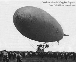
Wingfoot Air Express crash
1919 in-flight fire and crash of a blimp in Chicago
Distance: Approx. 47 meters
Latitude and longitude: 41.878125,-87.6323
The Wingfoot Air Express was an early Goodyear blimp that caught fire and crashed into the Illinois Trust and Savings Building in Chicago on July 21, 1919. The Type FD airship, manufactured and owned by the Goodyear Tire and Rubber Company, was transporting passengers from Grant Park to the White City amusement park. One crew member, two passengers and ten bank employees were killed in what was the worst airship disaster in the United States up to that time.
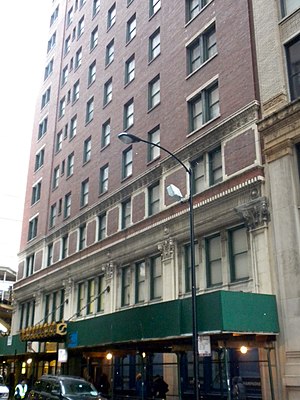
Fort Dearborn Hotel
United States historic place
Distance: Approx. 151 meters
Latitude and longitude: 41.87666667,-87.63111111
The Fort Dearborn Hotel is a skyscraper and former hotel located at 401 S. Lasalle St. in the Loop community area of Chicago, Illinois. The 17-story hotel was designed by Holabird & Roche and finished in 1914.

Ceres Cafe
Restaurant in Illinois , United States
Distance: Approx. 47 meters
Latitude and longitude: 41.878125,-87.63225
Ceres Cafe is a diner in the lobby of the Chicago Board of Trade Building. It takes its name from the Roman goddess Ceres, which is a statue on the top of the building. It has been known as a place for commodities traders that serves very strong alcoholic beverages.

Phenix Building (Chicago)
High-rise office in Chicago, Illinois
Distance: Approx. 82 meters
Latitude and longitude: 41.878,-87.6314
The Phenix (aka Phoenix) Building was an office building in Chicago designed by the noted Chicago architectural firm of Burnham and Root. It was built by the Phenix Mutual Fire Insurance Company of Brooklyn, New York and occupied the block fronting Jackson Boulevard between Pacific Avenue (now LaSalle Street) and Clark Street. When completed in 1887, the building was seen as "the latest addition to Chicago's magnificent architectural structures".
Weather in this IP's area
few clouds
13 Celsius
12 Celsius
11 Celsius
14 Celsius
1021 hPa
54 %
1021 hPa
999 hPa
10000 meters
2.57 m/s
320 degree
20 %
06:54:18
18:21:49