Country:
 Canada
Region:
City:
Latitude and Longitude:
Time Zone:
Postal Code:
IP information under different IP Channel
ip-api
Country
Region
City
ASN
Time Zone
ISP
Blacklist
Proxy
Latitude
Longitude
Postal
Route
IPinfo
Country
Region
City
ASN
Time Zone
ISP
Blacklist
Proxy
Latitude
Longitude
Postal
Route
MaxMind
Country
Region
City
ASN
Time Zone
ISP
Blacklist
Proxy
Latitude
Longitude
Postal
Route
Luminati
Country
CARegion
qc
City
rimouski
ASN
Time Zone
America/Toronto
ISP
CC-3272
Latitude
Longitude
Postal
db-ip
Country
Region
City
ASN
Time Zone
ISP
Blacklist
Proxy
Latitude
Longitude
Postal
Route
ipdata
Country
Region
City
ASN
Time Zone
ISP
Blacklist
Proxy
Latitude
Longitude
Postal
Route
Popular places and events near this IP address

Abercorn, Quebec
Village municipality in Quebec, Canada
Distance: Approx. 8440 meters
Latitude and longitude: 45.03333333,-72.66666667
Abercorn is a small village located within the Brome-Missisquoi Regional County Municipality in the Estrie region of Quebéc, Canada. The population as of the 2021 Canada Census, was 341. It currently covers a land area of approximately 26.73 km² (10.32 sq mi) and Is bordered by Sutton to the north and east, Frelighsburg to the west, and Richford, Vermont to the south.

Sutton, Quebec
Town in Quebec, Canada
Distance: Approx. 69 meters
Latitude and longitude: 45.1,-72.61666667
Sutton is a town in southeastern Quebec. It is part of the Brome-Missisquoi Regional County Municipality in the administrative region of the Estrie. The population as of the Canada 2021 Census was 4,548.
CIDI-FM
Radio station in Quebec, Canada
Distance: Approx. 9815 meters
Latitude and longitude: 45.18611111,-72.58833333
CIDI-FM is an English language community radio station with French programming that broadcasts at 99.1 FM in Brome Lake, Quebec, Canada. Owned by Radio communautaire Missisquoi, a non-profit organization, the station was licensed in 2003.
Mont Sutton
Distance: Approx. 4278 meters
Latitude and longitude: 45.10416667,-72.56166667
Mont Sutton is a four-season attraction, well known for skiing in winter, but now offering a range of summer activities: mountain biking, disc golf, chairlift ride, giant zipline and a zipline coaster. It's located in Sutton, Quebec, Canada, in the Estrie administrative region and in the Eastern Townships touristic region.
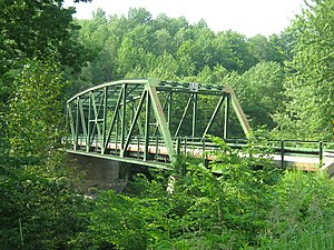
Missisquoi River Bridge
Bridge in Vermont and Sutton, Quebec
Distance: Approx. 9877 meters
Latitude and longitude: 45.01361111,-72.58777778
The Mississquoi River Bridge (known in Canada as the Pont de la Vallée) is a steel truss bridge, spanning the Missisquoi River between Richford, Vermont and Sutton, Quebec on the Canada–United States border. It connects Chemin de la Vallée Missisquoi in Sutton with Vermont Route 105A in Richford, between the border stations of the East Richford–Glen Sutton Border Crossing. The bridge was built by the state of Vermont in 1929, and is one of two in the state built by the Pittsburgh-Des Moines Steel Company.
Weather in this IP's area
clear sky
7 Celsius
7 Celsius
6 Celsius
9 Celsius
1033 hPa
78 %
1033 hPa
1009 hPa
10000 meters
1.14 m/s
1.2 m/s
170 degree
07:10:37
18:00:05