74.205.219.252 - IP Lookup: Free IP Address Lookup, Postal Code Lookup, IP Location Lookup, IP ASN, Public IP
Country:
Region:
City:
Location:
Time Zone:
Postal Code:
ISP:
ASN:
language:
User-Agent:
Proxy IP:
Blacklist:
IP information under different IP Channel
ip-api
Country
Region
City
ASN
Time Zone
ISP
Blacklist
Proxy
Latitude
Longitude
Postal
Route
db-ip
Country
Region
City
ASN
Time Zone
ISP
Blacklist
Proxy
Latitude
Longitude
Postal
Route
IPinfo
Country
Region
City
ASN
Time Zone
ISP
Blacklist
Proxy
Latitude
Longitude
Postal
Route
IP2Location
74.205.219.252Country
Region
british columbia
City
vancouver
Time Zone
America/Vancouver
ISP
Language
User-Agent
Latitude
Longitude
Postal
ipdata
Country
Region
City
ASN
Time Zone
ISP
Blacklist
Proxy
Latitude
Longitude
Postal
Route
Popular places and events near this IP address

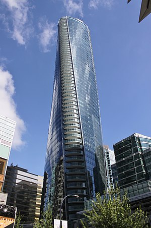
The Melville
Skyscraper located in the Coal Harbour neighbourhood of the downtown core of Vancouver
Distance: Approx. 291 meters
Latitude and longitude: 49.2879,-123.1236
The Melville is a skyscraper located at 1189 Melville Street in the Coal Harbour neighbourhood of the city's downtown core of Vancouver, British Columbia, Canada. The building is the sixth tallest building in the city. The Melville is also the tallest fully residential building in Western Canada.

Living Shangri-La
Mixed-use skyscraper in Vancouver, British Columbia
Distance: Approx. 356 meters
Latitude and longitude: 49.28583333,-123.12361111
Living Shangri-La is a mixed-use skyscraper in downtown Vancouver, British Columbia, Canada, and is the tallest building in the city and province. The 62-storey Shangri-La tower contains a 5-star hotel and its offices on the first 15 floors, with condominium apartment units occupying the rest of the tower. The building's podium complex also includes a spa, Urban Fare specialty grocery store, a Vancouver Art Gallery public display, and a curated public sculpture garden.

Empire Landmark Hotel
Former hotel in Vancouver, British Columbia, Canada. Tallest demolished building in Canada.
Distance: Approx. 238 meters
Latitude and longitude: 49.28805556,-123.13083333
The Empire Landmark Hotel, often referred to by its original name, the Sheraton Landmark, was the tallest hotel in Vancouver, British Columbia. It was located on one of Vancouver's busiest thoroughfares at 1400 Robson Street, in the West End of Downtown Vancouver. The building was revolutionary at the time, as it had a revolving restaurant on its top floor, Cloud 9, which was one of only two revolving restaurants in Vancouver, the other being the Harbour Centre.
1994 Vancouver Stanley Cup riot
1994 riot in downtown Vancouver, Canada, following an ice hockey game
Distance: Approx. 418 meters
Latitude and longitude: 49.28444444,-123.12472222
The 1994 Vancouver Stanley Cup Riot occurred in Downtown Vancouver, British Columbia, Canada, on the evening of June 14, 1994, and continued into the following morning. The riot followed Game 7 of the 1994 Stanley Cup Finals in which the Vancouver Canucks lost to the New York Rangers. It was Vancouver's first riot since 1972, when the Rolling Stones American Tour 1972 led to confrontations between the police and 2,000 outside the Pacific Coliseum.

Paradox Hotel Vancouver
Hotel skyscraper in British Columbia, Canada
Distance: Approx. 357 meters
Latitude and longitude: 49.28611111,-123.12333333
The Paradox Hotel Vancouver, formerly known as the Trump International Hotel and Tower Vancouver, is a residential skyscraper and hotel in Downtown Vancouver, British Columbia, Canada. The 60-storey, 188-metre (617 ft) tower in which the hotel is located is at 1151 West Georgia Street and was completed in 2016. The tower is the second tallest building in Vancouver, after the Shangri-La tower located across West Georgia Street.

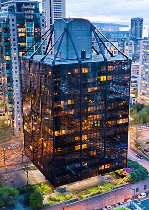
Westcoast Building
Building in Vancouver, British Columbia
Distance: Approx. 143 meters
Latitude and longitude: 49.288988,-123.127529
The Westcoast Building is a 15-storey former office building in Vancouver, British Columbia. It was constructed in 1969 as the headquarters of Westcoast Transmission Company. In 2005 it was converted to residential and is now called the Qube.
First Church of Christ, Scientist (Vancouver)
Distance: Approx. 250 meters
Latitude and longitude: 49.2864,-123.1248
The former First Church of Christ, Scientist is an historic Christian Science church edifice located at 1160 Georgia Street in the west end of Vancouver, British Columbia, Canada. It was designed in the Colonial Revival style by the noted Vancouver architectural firm of Matheson and De Guerre. Built in 1918, it is a two-storey brick building with basement.
The Listel Hotel
Distance: Approx. 144 meters
Latitude and longitude: 49.28706,-123.12932
The Listel Hotel is a hotel located in the downtown area of the Canadian city of Vancouver, British Columbia
Discovery Community College
Distance: Approx. 435 meters
Latitude and longitude: 49.28498056,-123.12329444
Discovery Community College is a private college in Campbell River, British Columbia, Canada, established in 1996.

Roedde House Museum
Museum (Victorian era) in British Columbia, Canada
Distance: Approx. 346 meters
Latitude and longitude: 49.2869,-123.1322
The Roedde House Museum is a late-Victorian home located at 1415 Barclay Street in Vancouver, Canada. It was the home of Gustav Roedde and his family. The house was built in 1893 and was allegedly designed by architect Francis Rattenbury in the Queen Anne Revival style.
BOLDfest
Canadian annual lesbian-communal conference
Distance: Approx. 398 meters
Latitude and longitude: 49.2883,-123.1222
BOLDfest (Bold Older Lesbians and Dykes) is an annual conference held in Vancouver, British Columbia to create community for lesbians over 45 from Canada and the United States. The conference is held by BOLD, a non-profit society, which states that its mission is "to raise the visibility of older lesbians, and to provide a venue to meet and to share information and opportunities for learning, networking, and organizing". BOLDfest was created to create community for older lesbians, combat isolation and age-based exclusion from other facets of the queer community, and to remember and celebrate lesbian histories.

MacMillan Bloedel Building
Building in Vancouver, British Columbia
Distance: Approx. 440 meters
Latitude and longitude: 49.285814,-123.122269
The MacMillan Bloedel Building is a 27-storey office tower in Vancouver, British Columbia. The building was constructed as the head office of the forestry company MacMillan Bloedel and was designed by Erickson/Massey Architects with Francis Donaldson. The partner-in-charge of design was Arthur Erickson, who conceived the building in 1965.
Weather in this IP's area
overcast clouds
7 Celsius
5 Celsius
5 Celsius
8 Celsius
1032 hPa
80 %
1032 hPa
1014 hPa
10000 meters
2.68 m/s
4.47 m/s
239 degree
87 %