Country:
 USA
USARegion:
City:
Latitude and Longitude:
Time Zone:
Postal Code:
IP information under different IP Channel
ip-api
Country
Region
City
ASN
Time Zone
ISP
Blacklist
Proxy
Latitude
Longitude
Postal
Route
IPinfo
Country
Region
City
ASN
Time Zone
ISP
Blacklist
Proxy
Latitude
Longitude
Postal
Route
MaxMind
Country
Region
City
ASN
Time Zone
ISP
Blacklist
Proxy
Latitude
Longitude
Postal
Route
Luminati
Country
USASN
Time Zone
America/Chicago
ISP
INTERNAP-2BLK
Latitude
Longitude
Postal
db-ip
Country
Region
City
ASN
Time Zone
ISP
Blacklist
Proxy
Latitude
Longitude
Postal
Route
ipdata
Country
Region
City
ASN
Time Zone
ISP
Blacklist
Proxy
Latitude
Longitude
Postal
Route
Popular places and events near this IP address
Cubberley Community Center
Community center in Palo Alto, California, US
Distance: Approx. 1844 meters
Latitude and longitude: 37.417874,-122.107544
Cubberley Community Center known locally as "Cubberley", is a community center in Palo Alto, California, that has been in operation since 1990. It is housed on the campus of the former Ellwood P. Cubberley High School. Space is available for rent by the hour, either one-time or on a regular basis for community related meetings, seminars, social events, dances, theatre performances, music rehearsals and athletic events.

Intuit
American financial software company
Distance: Approx. 1372 meters
Latitude and longitude: 37.42722222,-122.09638889
Intuit Inc. is an American multinational business software company that specializes in financial software. The company is headquartered in Mountain View, California, and the CEO is Sasan Goodarzi.

Rengstorff House
Historic house in California, United States
Distance: Approx. 1963 meters
Latitude and longitude: 37.43145556,-122.0871
The Rengstorff House was one of the first houses to be built in Mountain View, California. It was built c. 1867 by Henry Rengstorff, a prominent local businessman who operated a ferry between San Francisco and Mountain View.
Kehillah Jewish High School
Independent coeducational secondary school in Palo Alto, California, United States
Distance: Approx. 1130 meters
Latitude and longitude: 37.4249,-122.1045
Kehillah Jewish High School is an independent college preparatory high school located in Palo Alto, California. "Kehillah" is a Hebrew word meaning "community." In the fall of 2005, the school moved from its original location in San Jose to its new campus at 3900 Fabian Way, Palo Alto, where it also hosted the Keddem Congregation (Reconstructionist Judaism) for several years. Kehillah Jewish High School was founded in 1999 and opened in the fall of 2002 on the Blackford High School campus in San Jose with 32 9th grade students.
Palo Alto Chinese School
School in California, United States
Distance: Approx. 1701 meters
Latitude and longitude: 37.4216,-122.1195
Founded in 1963, Palo Alto Chinese School (PACS) is located in Palo Alto, California and is the oldest Chinese school in the San Francisco Bay Area. The school was formed with a merger between a Cantonese school and a Mandarin school. The history of the Cantonese school could be traced back to 1960, when the Santa Clara Overseas Chinese School was founded.

Ellwood P. Cubberley High School
Public high school in the United States
Distance: Approx. 1844 meters
Latitude and longitude: 37.417874,-122.107544
Ellwood P. Cubberley High School (1956–1979), known locally as "Cubberley", was one of three public high schools in Palo Alto, California. The site of the closed school is now named Cubberley Community Center and used for many diverse activities.

CK-12 Foundation
California-based non-profitable organization
Distance: Approx. 88 meters
Latitude and longitude: 37.43503056,-122.10960833
The CK-12 Foundation is a California-based non-profit organization which aims to increase access to low-cost K-12 education in the United States and abroad. CK-12 provides free and customizable K-12 open educational resources aligned to state curriculum standards. As of 2022, the foundation's tools were used by over 200,000,000 students worldwide.

Permanente Creek
River in California, United States
Distance: Approx. 2051 meters
Latitude and longitude: 37.43333333,-122.08583333
Permanente Creek is a 13.3-mile-long (21.4 km) stream originating on Black Mountain in Santa Clara County, California, United States. Named by early Spanish explorers as Arroyo Permanente or Río Permanente because of its perennial flow, the creek descends the east flank of Black Mountain then courses north through Los Altos and Mountain View, discharging into southwest San Francisco Bay historically at the Mountain View Slough but now virtually entirely diverted via the Permanente Creek Diversion Channel to Stevens Creek and Whisman Slough in San Francisco Bay.

Barron Creek
River in California, United States
Distance: Approx. 59 meters
Latitude and longitude: 37.43388889,-122.10916667
Barron Creek is a 5.8-mile-long (9.3 km) northward-flowing stream originating in the lower foothills of the Santa Cruz Mountains in Los Altos Hills in Santa Clara County, California, United States. It courses northerly through the cities of Los Altos Hills and Palo Alto, before joining Adobe Creek just south of U.S. Highway 101. As Adobe Creek, its waters continue northwards to southwest San Francisco Bay after crossing under Highway 101 and traversing the Palo Alto Flood Basin.
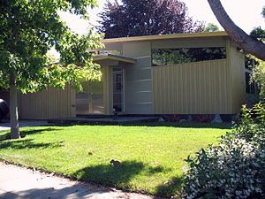
Green Gables (Palo Alto, California)
Historic place in California, United States
Distance: Approx. 1848 meters
Latitude and longitude: 37.44583333,-122.12416667
Green Gables is a 1950s subdivision located in Palo Alto, California, United States. The subdivision was developed by Joseph Eichler, whose company built its first 63 homes in 1950. Eichler hired the architecture firm Anshen & Allen to design the one-story modernist houses.
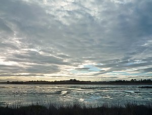
Charleston Slough
Distance: Approx. 1682 meters
Latitude and longitude: 37.4418837,-122.0924628
Charleston Slough is a former Leslie salt pond that is now reverting to marsh on the western shore of San Francisco Bay.

The Foster Museum
Art museum in Palo Alto, California
Distance: Approx. 1449 meters
Latitude and longitude: 37.42369759,-122.09966617
The Foster Museum is a private non-profit single-artist museum located in Palo Alto, California, United States dedicated to the watercolor wilderness Journeys of artist-explorer Tony Foster (1946–). It houses the permanent collection of the Foster Art & Wilderness Foundation and opened to the public in 2016, offering free admission by appointment.
Weather in this IP's area
clear sky
14 Celsius
14 Celsius
12 Celsius
16 Celsius
1011 hPa
90 %
1011 hPa
1011 hPa
10000 meters
1.54 m/s
290 degree
06:45:16
19:26:54