Country:
 USA
USARegion:
City:
Latitude and Longitude:
Time Zone:
Postal Code:
IP information under different IP Channel
ip-api
Country
Region
City
ASN
Time Zone
ISP
Blacklist
Proxy
Latitude
Longitude
Postal
Route
IPinfo
Country
Region
City
ASN
Time Zone
ISP
Blacklist
Proxy
Latitude
Longitude
Postal
Route
MaxMind
Country
Region
City
ASN
Time Zone
ISP
Blacklist
Proxy
Latitude
Longitude
Postal
Route
Luminati
Country
USASN
Time Zone
America/Chicago
ISP
E2OPEN-1
Latitude
Longitude
Postal
db-ip
Country
Region
City
ASN
Time Zone
ISP
Blacklist
Proxy
Latitude
Longitude
Postal
Route
ipdata
Country
Region
City
ASN
Time Zone
ISP
Blacklist
Proxy
Latitude
Longitude
Postal
Route
Popular places and events near this IP address

Bair Island
Swamp in Redwood City, San Mateo County, United States
Distance: Approx. 2720 meters
Latitude and longitude: 37.5299362,-122.2221881
Bair Island is a marsh area in Redwood City, California, covering 3,000 acres (1,200 ha), and includes three islands: Inner, Middle and Outer islands. Bair Island is part of the larger Don Edwards San Francisco Bay National Wildlife Refuge. It is surrounded by the Steinberger slough to the northwest and Redwood Creek to the southeast.
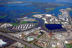
Port of Redwood City
Port in the San Francisco Bay
Distance: Approx. 680 meters
Latitude and longitude: 37.5132701,-122.2085765
The Port of Redwood City is a marine freight terminal on the western side of the southern San Francisco Bay, on the West Coast of the United States. This marine terminal is situated within the city of Redwood City, California. The port was developed from a natural deepwater channel discovered in the year 1850, at the mouth of Redwood Creek.
Redwood Creek (San Mateo County)
River in California, United States
Distance: Approx. 1638 meters
Latitude and longitude: 37.52641667,-122.19622222
Redwood Creek is a 9.5-mile-long (15.3 km) perennial stream located in San Mateo County, California, United States which discharges into South San Francisco Bay. The Port of Redwood City, the largest deepwater port in South San Francisco Bay, is situated on the east bank of Redwood Creek near its mouth, where the creek becomes a natural deepwater channel.

Westpoint Slough
Distance: Approx. 1000 meters
Latitude and longitude: 37.5060482,-122.1927429
Westpoint Slough is the largest of several sloughs feeding into Redwood Creek in San Mateo County, California, United States. This slough is surrounded by extensive undisturbed marshlands including Greco Island, which forms its northern boundary. The channel of Westpoint Slough contains considerable mudflat areas; moreover, both the marshes and mudflats offer considerable habitat area for local and migratory wildlife, especially birds.
Seaport Centre
Business park
Distance: Approx. 1876 meters
Latitude and longitude: 37.50155,-122.21747
Seaport Centre is a high-tech business park located in Redwood City, California, United States, and as of 2007 is one of the largest biotechnology research complexes in the San Francisco Bay Area. The property consists of 623,000 square feet (57,900 m2) of developed building area, and is situated in proximity to the Port of Redwood City. The property is classified as Class A office space and is constructed as a series of separate buildings.

The Guardian (sculpture)
Artwork in Redwood City, California
Distance: Approx. 2731 meters
Latitude and longitude: 37.4931,-122.2204
The Guardian is a public artwork by artist Ante Buljan, located at the front of the Redwood City Police Station, in Redwood City, California, United States.

Steamboat Jenny Lind
Distance: Approx. 3608 meters
Latitude and longitude: 37.54,-122.18
The steamboat Jenny Lind was a ferry that exploded in San Francisco Bay on April 11, 1853 while on course to San Francisco from Alviso, California, killing many residents of Alviso and San Jose. The boiler exploded as the steamboat passed the Redwood City inlet (about 37.54°N 122.18°W / 37.54; -122.18), minutes after dinner was called for the passengers. The worst of the casualties were among the women and children who were seated first at dinner.
Westpoint Harbor
Port in United States
Distance: Approx. 605 meters
Latitude and longitude: 37.512768,-122.194191
Westpoint Harbor is a marina that opened in 2008 at the mouth of the Westpoint Slough located in Redwood City, California.
Marine Science Institute (San Francisco Bay)
Distance: Approx. 1643 meters
Latitude and longitude: 37.504859,-122.217147
The Marine Science Institute (MSI) is a nonprofit organization focusing on marine science research and education. MSI was founded in 1970 and currently is situated in Redwood City, California, adjacent to the Port of Redwood City. In the San Francisco Bay Area MSI has a mission driving marine education for schoolchildren and continues to receive grants to supplement their donations.

Arrillaga Family Rowing and Sailing Center
Distance: Approx. 1713 meters
Latitude and longitude: 37.504752,-122.217973
The Stanford University Arrillaga Family Rowing and Sailing Center (or Stanford Rowing and Sailing Center) is a boating facility utilized by Stanford Cardinal Athletics for sailing and rowing sporting activities. It is located at the Port of Redwood City along Redwood creek in Redwood City, California.

Greco Island
Island in California, United States
Distance: Approx. 1702 meters
Latitude and longitude: 37.5177146,-122.1830205
Greco Island is a wetland island in Redwood City, California. Greco Island is part of the larger Don Edwards San Francisco Bay National Wildlife Refuge. Westpoint Slough follows the South side of the island while Redwood Creek is along the West.

Pacific Shores Center
Distance: Approx. 182 meters
Latitude and longitude: 37.51153,-122.20288
Pacific Shores Center is a high-tech business park located in Redwood City, California, adjacent to the Port of Redwood City.
Weather in this IP's area
clear sky
23 Celsius
22 Celsius
21 Celsius
26 Celsius
1017 hPa
24 %
1017 hPa
1017 hPa
10000 meters
4.63 m/s
320 degree
07:20:10
18:27:10