Country:
 USA
USARegion:
City:
Latitude and Longitude:
Time Zone:
Postal Code:
IP information under different IP Channel
ip-api
Country
Region
City
ASN
Time Zone
ISP
Blacklist
Proxy
Latitude
Longitude
Postal
Route
IPinfo
Country
Region
City
ASN
Time Zone
ISP
Blacklist
Proxy
Latitude
Longitude
Postal
Route
MaxMind
Country
Region
City
ASN
Time Zone
ISP
Blacklist
Proxy
Latitude
Longitude
Postal
Route
Luminati
Country
USASN
Time Zone
America/Chicago
ISP
INTERNAP-2BLK
Latitude
Longitude
Postal
db-ip
Country
Region
City
ASN
Time Zone
ISP
Blacklist
Proxy
Latitude
Longitude
Postal
Route
ipdata
Country
Region
City
ASN
Time Zone
ISP
Blacklist
Proxy
Latitude
Longitude
Postal
Route
Popular places and events near this IP address

Santa Venetia, California
Census-designated place in California, United States
Distance: Approx. 907 meters
Latitude and longitude: 37.99861111,-122.52527778
Santa Venetia is a census-designated place (CDP) in Marin County, California, United States. It is located 1.5 miles (2.4 km) north of downtown San Rafael, at an elevation of 56 feet (17 m). The population was 4,289 at the 2020 census.
Autodesk
American software company
Distance: Approx. 21 meters
Latitude and longitude: 38.0055,-122.5308
Autodesk, Inc. is an American multinational software corporation that provides software products and services for the architecture, engineering, construction, manufacturing, media, education, and entertainment industries. Autodesk is headquartered in San Francisco, California, and has offices worldwide.

Marin County Civic Center
United States historic place
Distance: Approx. 638 meters
Latitude and longitude: 37.99972222,-122.53
The Marin County Civic Center, designed by Frank Lloyd Wright, is located in San Rafael, California, the county seat of Marin County, California, United States. Groundbreaking for the Civic Center Administration Building took place in 1960, after Wright's death and under the watch of Wright's protégé, Aaron Green; it was completed in 1962. The Hall of Justice was begun in 1966 and completed in 1969.

The Marin School
Private school in San Rafael, Marin County, California, United States
Distance: Approx. 936 meters
Latitude and longitude: 37.99889167,-122.52424167
The Marin School (TMS) was a private high school located in San Rafael, California. The school was named after Marin County in which it is located. The school closed permanently at the end of 2022-23 school year, citing a drop in enrollment.
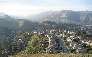
Terra Linda, San Rafael, California
Place in California, United States
Distance: Approx. 1648 meters
Latitude and longitude: 38.00416667,-122.54972222
Terra Linda (Portuguese for "Beautiful Land") is a district of the city of San Rafael, California. It was formerly an unincorporated community within Marin County. It lies at an elevation of 171 feet (52 m).
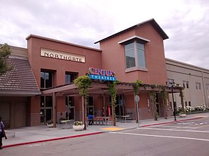
Northgate Mall (San Rafael, California)
Shopping mall in California, United States
Distance: Approx. 1140 meters
Latitude and longitude: 38.005233,-122.543997
Northgate Mall is a shopping mall located in the Terra Linda neighborhood of San Rafael, California, 15 miles (24 km) north of the Golden Gate Bridge. It's the largest of three shopping centers in San Rafael called Northgate. It was managed by The Macerich Company until 2017 and is now managed by Merlone Geier Partners.
Harmony Sweepstakes A Cappella Festival
Distance: Approx. 409 meters
Latitude and longitude: 38.00222222,-122.53333333
The Harmony Sweepstakes A Cappella Festival is an annual showcase and competition for a cappella groups of all vocal styles. The competition is organized into seven regional events across the United States, with each winning group advancing to the National Finals in San Rafael, California.
Los Ranchitos
Unincorporated community in California, United States
Distance: Approx. 1705 meters
Latitude and longitude: 37.99305556,-122.5425
Los Ranchitos (Spanish for 'The Little Ranches') is an unincorporated community in Marin County, California, United States. It lies at an elevation of 66 feet (20 m). Los Ranchitos was developed in 1949 into lots of at least one acre in size, with most averaging 1-2 acres.
Marin County Civic Center attacks
Attacks in California, United States, in 1970
Distance: Approx. 638 meters
Latitude and longitude: 37.99972222,-122.53
The Marin County Civic Center attacks were two related attacks in 1970 at the Marin County Superior Court, located in the Marin County Civic Center in San Rafael, California, United States, tied to escalating racial tensions in the state's criminal justice system. On August 7, 17-year-old Jonathan P. Jackson attempted to coerce the release of the Soledad Brothers (including Jackson's older brother George) by kidnapping Superior Court judge Harold Haley from the Marin County Civic Center. As the kidnappers attempted to leave with five hostages by car, court officers shot at Jackson's retreating van.

Marin Civic Center station
Distance: Approx. 703 meters
Latitude and longitude: 38.0016,-122.5374
Marin Civic Center station is a Sonoma–Marin Area Rail Transit station in San Rafael, California, located adjacent to the Marin County Civic Center.

Marin County Superior Court
California superior court with jurisdiction over Marin Country
Distance: Approx. 746 meters
Latitude and longitude: 37.9987,-122.5311
The Superior Court of California, County of Marin, is the California superior court with jurisdiction over Marin County. It is housed in the landmark Marin County Civic Center, designed by architect Frank Lloyd Wright and completed in 1962.

Puerto Suello Hill Tunnel
California rail tunnel
Distance: Approx. 1811 meters
Latitude and longitude: 37.989201,-122.529114
Puerto Suello Tunnel is a quarter-mile long rail tunnel in San Rafael, California. It was constructed in 1879, by the San Francisco and North Pacific Railroad.
Weather in this IP's area
overcast clouds
12 Celsius
12 Celsius
11 Celsius
15 Celsius
1011 hPa
92 %
1011 hPa
1010 hPa
10000 meters
2.57 m/s
310 degree
100 %
06:46:34
19:28:58