Country:
 USA
USARegion:
City:
Latitude and Longitude:
Time Zone:
Postal Code:
IP information under different IP Channel
ip-api
Country
Region
City
ASN
Time Zone
ISP
Blacklist
Proxy
Latitude
Longitude
Postal
Route
IPinfo
Country
Region
City
ASN
Time Zone
ISP
Blacklist
Proxy
Latitude
Longitude
Postal
Route
MaxMind
Country
Region
City
ASN
Time Zone
ISP
Blacklist
Proxy
Latitude
Longitude
Postal
Route
Luminati
Country
USASN
Time Zone
America/Chicago
ISP
INTERNAP-BLK3
Latitude
Longitude
Postal
db-ip
Country
Region
City
ASN
Time Zone
ISP
Blacklist
Proxy
Latitude
Longitude
Postal
Route
ipdata
Country
Region
City
ASN
Time Zone
ISP
Blacklist
Proxy
Latitude
Longitude
Postal
Route
Popular places and events near this IP address

Glenbrook (Stamford)
Neighborhood in Fairfield County, Connecticut, United States
Distance: Approx. 1463 meters
Latitude and longitude: 41.06472222,-73.52611111
Glenbrook is a neighborhood of the city of Stamford, Connecticut. Spanning an area of about 1.7 square miles (4.4 km2), about 15,400 people live in Glenbrook as of 2007. Glenbrook is located on the eastern side of the city, east of Downtown, north of the East Side and the Cove sections and south of the Springdale section.

East Side of Stamford
Area of Stamford in Connecticut, US
Distance: Approx. 1080 meters
Latitude and longitude: 41.0561,-73.5213
The East Side of Stamford is a neighborhood in the city of Stamford, Connecticut. Per the city government's definition, the East Side lies directly to the east of Downtown, southeast of Glenbrook, north of The Cove, and to the west of Darien. The East Side serves as the headquarters for a number of corporations, such as World Wrestling Entertainment and NBC Sports, and hosts corporate offices for a number of large multinationals, such as that of Deloitte at 695 East Main Street.
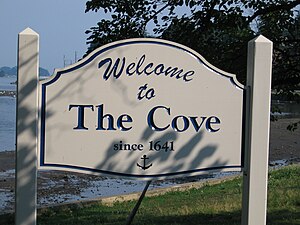
The Cove, Stamford, Connecticut
Neighborhood in Stamford, Connecticut, US
Distance: Approx. 1270 meters
Latitude and longitude: 41.0489,-73.509
The Cove is a neighborhood located in the southeast corner of Stamford, Connecticut. It is an area of mostly modest homes with some very expensive homes along the shoreline.
Noroton Heights, Connecticut
Census-designated place in Connecticut, United States
Distance: Approx. 1458 meters
Latitude and longitude: 41.07055556,-73.49888889
Noroton Heights is a village and census-designated place (CDP) in the town of Darien, Connecticut, United States. The community is located on Connecticut's Gold Coast. Located close to Long Island Sound, in the Connecticut panhandle, it is approximately 35 miles (56 km) northeast of Midtown Manhattan and immediately to the east of Stamford.

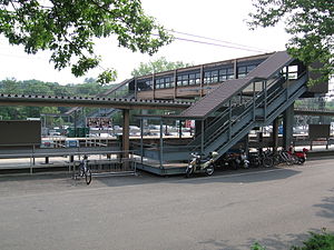
Noroton Heights station
Metro-North Railroad station in Connecticut
Distance: Approx. 1410 meters
Latitude and longitude: 41.06902,-73.49752
Noroton Heights station is a commuter rail station on the Metro-North Railroad New Haven Line located in the Noroton Heights neighborhood of Darien, Connecticut.
West Side of Stamford
Distance: Approx. 1463 meters
Latitude and longitude: 41.06472222,-73.52611111
The West Side of Stamford is the area immediately west of Downtown Stamford, covering the area north of Interstate 95 between the Greenwich town line and the Rippowam River. The northern boundary is commonly taken as West Broad Street and Palmers Hill Road. Another version of the boundaries of the West Side has it located between Stillwater Avenue, Broad Street, West Main Street and West Avenue up to Exit 6 Interstate 95.

Glenbrook station (Metro-North)
Metro-North Railroad station in Connecticut
Distance: Approx. 1422 meters
Latitude and longitude: 41.0705,-73.5199
Glenbrook station is a commuter rail stop on the New Canaan Branch of the Metro-North Railroad's New Haven Line, located in the Glenbrook section of Stamford, Connecticut.
AmeriCares
Global non-profit organization focused on health and development
Distance: Approx. 974 meters
Latitude and longitude: 41.0651,-73.5194
AmeriCares is a global non-profit organization focused on health and development that responds to individuals affected by poverty, disaster, or crisis. The organization addresses poverty, disasters, or crises with medicine, medical supplies and health programs. Since it was established in 1979, AmeriCares has delivered more than $17 billion in humanitarian aid to 164 countries to address issues like natural disasters, the restoration of a community after natural disasters, and ongoing health crises and inequality.
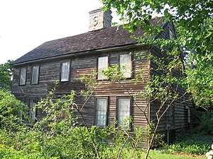
Pond-Weed House
Historic house in Connecticut, United States
Distance: Approx. 561 meters
Latitude and longitude: 41.05972222,-73.50305556
The Pond-Weed House is a historic house at corner of the old Boston Post Road and Hollow Tree Ridge Road in the Noroton section of Darien, Connecticut. It has also been known as The House Under the Hill and Half-Way House. Built ca.
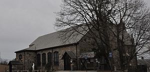
St. Benedict's Church (Stamford, Connecticut)
Historic church in Connecticut, United States
Distance: Approx. 1324 meters
Latitude and longitude: 41.05166667,-73.52055556
Saint Benedict - Our Lady of Montserrat, or simply St. Benedict's Church, is a Catholic church in Stamford, Connecticut, in the Diocese of Bridgeport. The historic brick Neo-Tudor church at 1A St.

Saint Maurice Church (Connecticut)
Church in Connecticut, United States
Distance: Approx. 1246 meters
Latitude and longitude: 41.06631389,-73.522225
St Maurice is a Roman Catholic church in Stamford, Connecticut, part of the Diocese of Bridgeport.

Titan Towers
Headquarters of American professional wrestling promotion WWE
Distance: Approx. 122 meters
Latitude and longitude: 41.0592,-73.5097
Titan Towers is an office building located in Stamford, Connecticut, United States. It served as the global headquarters for the American professional wrestling and entertainment company WWE from 1991 to 2023. WWE, a subsidiary of TKO Group Holdings (TKO), later moved their global headquarters to Washington Boulevard in Stamford, with TKO establishing its headquarters in New York City.
Weather in this IP's area
light rain
18 Celsius
18 Celsius
17 Celsius
19 Celsius
1009 hPa
88 %
1009 hPa
1009 hPa
10000 meters
2.68 m/s
4.47 m/s
279 degree
100 %
06:57:14
18:25:55