Country:
 USA
USARegion:
City:
Latitude and Longitude:
Time Zone:
Postal Code:
IP information under different IP Channel
ip-api
Country
Region
City
ASN
Time Zone
ISP
Blacklist
Proxy
Latitude
Longitude
Postal
Route
IPinfo
Country
Region
City
ASN
Time Zone
ISP
Blacklist
Proxy
Latitude
Longitude
Postal
Route
MaxMind
Country
Region
City
ASN
Time Zone
ISP
Blacklist
Proxy
Latitude
Longitude
Postal
Route
Luminati
Country
USASN
Time Zone
America/Chicago
ISP
INTERNAP-BLK3
Latitude
Longitude
Postal
db-ip
Country
Region
City
ASN
Time Zone
ISP
Blacklist
Proxy
Latitude
Longitude
Postal
Route
ipdata
Country
Region
City
ASN
Time Zone
ISP
Blacklist
Proxy
Latitude
Longitude
Postal
Route
Popular places and events near this IP address

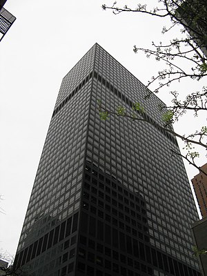
Citigroup Center
Office skyscraper in Manhattan, New York
Distance: Approx. 141 meters
Latitude and longitude: 40.75861111,-73.97027778
The Citigroup Center (formerly Citicorp Center and also known by its address, 601 Lexington Avenue) is an office skyscraper in the Midtown Manhattan neighborhood of New York City. Built in 1977 for Citibank, it is 915 feet (279 m) tall and has 1.3 million square feet (120,000 m2) of office space across 59 floors. The building was designed by architect Hugh Stubbins, associate architect Emery Roth & Sons, and structural engineer William LeMessurier.
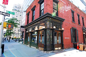
P. J. Clarke's
Restaurant in Manhattan, New York, U.S.
Distance: Approx. 141 meters
Latitude and longitude: 40.75901389,-73.96809444
P. J. Clarke's is a saloon and gastropub, established in 1884 and is one of the oldest continuously operating restaurants in NYC. It occupies a building located at 915 Third Avenue on the northeast corner of East 55th Street in Manhattan. It has a second location at 44 West 63rd Street on the southeast corner of Columbus Avenue. as well as a location at 250 Vesey St in Battery Park.

Lipstick Building
Office building in Manhattan, New York
Distance: Approx. 14 meters
Latitude and longitude: 40.75777778,-73.96888889
The Lipstick Building, also known as 885 Third Avenue and 53rd at Third, is a 453-foot-tall (138 m) office building at Third Avenue between 53rd Street and 54th Street in the Midtown Manhattan neighborhood of New York City. It was completed in 1986 and has 34 floors. The building was designed by John Burgee and Philip Johnson for Hines Interests and was developer Gerald D. Hines's first project in New York City.

El Morocco
Former nightclub in Manhattan
Distance: Approx. 119 meters
Latitude and longitude: 40.75875,-73.96975
El Morocco, sometimes nicknamed Elmo or Elmer, was a 20th-century nightclub in the Manhattan borough of New York City. It was frequented by the rich and famous from the 1930s until the decline of café society in the late 1950s. It was known for its blue zebra-stripe motif, designed by Vernon MacFarlane, and its official photographer, Jerome Zerbe.
919 Third Avenue
Office skyscraper in Manhattan, New York
Distance: Approx. 147 meters
Latitude and longitude: 40.75902778,-73.968
919 Third Avenue is an office building in New York City, New York, USA, built in 1971, and is located at the intersection of Third Avenue and East 55th Street in Midtown Manhattan. The building is 615 feet (187 meters) tall with 47 floors, and is tied with four other buildings, 750 7th Avenue, the New York Life Building, Tower 49, and The Epic in its position as the 118th tallest building in New York. The building was designed by Skidmore, Owings and Merrill.

53rd Street station (IRT Third Avenue Line)
Former Manhattan Railway elevated station (closed 1955)
Distance: Approx. 56 meters
Latitude and longitude: 40.75761111,-73.96944444
The 53rd Street station was a local station on the demolished IRT Third Avenue Line in Manhattan, New York City. It was served by local trains and had two tracks and two side platforms. The center track was built as part of the Dual Contracts and was used for express trains.
The Embers (nightclub)
Distance: Approx. 131 meters
Latitude and longitude: 40.7588,-73.9699
The Embers was a 1950s and 1960s-era New York City restaurant and nightclub formerly located at 161 East 54th Street between 3rd and Lexington Avenues. It was opened in late 1951 by former jazz musician Ralph Watkins, who had also been involved with clubs such as Bop City and Royal Roost, and featured many notable jazz acts over the years, including Marian McPartland, Dorothy Donegan, Joe Bushkin, George Shearing, Jonah Jones, Red Norvo, George Barnes and Carl Kress, and the Erroll Garner Trio. Artists who recorded there include Art Tatum, Buck Clayton, Teddy Wilson, and Dorothy Donegan.
Permanent Representative of Zambia to the United Nations
Distance: Approx. 147 meters
Latitude and longitude: 40.756637,-73.968396
The Zambian Permanent Representative in New York City is the official representative of the Government in Lusaka next the Headquarters of the United Nations.
Permanent Representative of South Africa to the United Nations
Distance: Approx. 150 meters
Latitude and longitude: 40.756731,-73.969773
The South African Permanent Representative in New York City is the official representative of the Government in Pretoria next the Headquarters of the United Nations.
Famous Door
Distance: Approx. 122 meters
Latitude and longitude: 40.757076,-73.969857
The Famous Door was a jazz club on New York's 52nd Street. It opened in 1935 and was one of the major clubs on the street, hosting leading jazz musicians until 1950, through changes of location and periods of closure.
Vong (restaurant)
Defunct restaurant in New York City, U.S.
Distance: Approx. 35 meters
Latitude and longitude: 40.75797222,-73.9685
Vong was a restaurant in New York City. It was located in the Lipstick Building. The restaurant served Southeast Asian cuisine and had received a Michelin star, before closing in 2009.
Mischa (restaurant)
Restaurant in New York City
Distance: Approx. 114 meters
Latitude and longitude: 40.758194,-73.970194
Mischa was an American / New American restaurant in New York City. The restaurant was located adjacent to the mezzanine of the food hall in the Citigroup Center.
Weather in this IP's area
light rain
19 Celsius
19 Celsius
17 Celsius
20 Celsius
1009 hPa
79 %
1009 hPa
1008 hPa
10000 meters
5.14 m/s
230 degree
100 %
06:58:53
18:27:57