Country:
 USA
USARegion:
City:
Latitude and Longitude:
Time Zone:
Postal Code:
IP information under different IP Channel
ip-api
Country
Region
City
ASN
Time Zone
ISP
Blacklist
Proxy
Latitude
Longitude
Postal
Route
IPinfo
Country
Region
City
ASN
Time Zone
ISP
Blacklist
Proxy
Latitude
Longitude
Postal
Route
MaxMind
Country
Region
City
ASN
Time Zone
ISP
Blacklist
Proxy
Latitude
Longitude
Postal
Route
Luminati
Country
USASN
Time Zone
America/Chicago
ISP
INTERNAP-BLK
Latitude
Longitude
Postal
db-ip
Country
Region
City
ASN
Time Zone
ISP
Blacklist
Proxy
Latitude
Longitude
Postal
Route
ipdata
Country
Region
City
ASN
Time Zone
ISP
Blacklist
Proxy
Latitude
Longitude
Postal
Route
Popular places and events near this IP address

Evanston, Wyoming
City in Wyoming, United States
Distance: Approx. 571 meters
Latitude and longitude: 41.26333333,-110.96472222
Evanston is a city in and the county seat of Uinta County, Wyoming, United States. The population was 11,747 at the 2020 census. It is located near the border with Utah.
Bear River State Park
State Park in Uinta County, Wyoming
Distance: Approx. 2102 meters
Latitude and longitude: 41.26472222,-110.93833333
Bear River State Park is a public recreation area straddling the Bear River on the east side of the city of Evanston, Wyoming. The 324-acre (131 ha) state park was established in 1991 and is managed by Wyoming Division of State Parks and Historic Sites.
Almy, Wyoming
Ghost town in Wyoming, United States
Distance: Approx. 7880 meters
Latitude and longitude: 41.33166667,-111.005
Almy was a coal mining camp in Uinta County, Wyoming, United States, near the town of Evanston. In 1881, an explosion killed 38 miners in the Central Pacific Mine, marking the first mine explosion west of the Mississippi River. Another explosion killed 13 in 1886, and a third explosion in Red Canyon in 1895 killed 62 miners, the third worst mining disaster in Wyoming history.

KEVA
Radio station in Evanston, Wyoming
Distance: Approx. 4431 meters
Latitude and longitude: 41.25805556,-111.01416667
KEVA (1240 AM) was a radio station broadcasting from Evanston, Wyoming. KEVA had been on the air in southwestern Wyoming since 1953, and was one of the area's oldest radio stations. It offered Classic country, local programming throughout the day as well, including news, classifieds, and weather.

Wyoming State Hospital
United States historic place
Distance: Approx. 1262 meters
Latitude and longitude: 41.26333333,-110.94944444
The Wyoming State Hospital, once known as the Wyoming State Insane Asylum, is located in Evanston, Wyoming, United States. The historic district occupies the oldest portion of the grounds and includes fifteen contributing buildings, including the main administrative building, staff and patient dormitories, staff apartments and houses, a cafeteria and other buildings, many of which were designed by Cheyenne, Wyoming architect William Dubois. Established in 1887, the historic buildings span the period 1907-1948.

Evanston Main Post Office
United States historic place
Distance: Approx. 245 meters
Latitude and longitude: 41.26722222,-110.96555556
The Evanston Main Post Office in Evanston, Wyoming was built in 1905 as part of a facilities improvement program by the United States Post Office Department. The post office in Evanston was nominated to the National Register of Historic Places (NRHP) as part of a thematic study comprising twelve Wyoming post offices built to standardized USPO plans in the early twentieth century. It was NRHP-listed as U.S. Post Office-Evanston Main.

Uinta County Courthouse
United States historic place
Distance: Approx. 225 meters
Latitude and longitude: 41.26638889,-110.96388889
The Uinta County Courthouse in Evanston, Wyoming is the oldest courthouse building in Wyoming, and one of the oldest permanent structures in Wyoming. Built in three stages, the first phase was a two-story jail, built in 1873. It was expanded with court facilities the following year, and in 1910 the main portion of the Georgian Revival structure was built with the present façade.

A. V. Quinn House
Historic house in Wyoming, United States
Distance: Approx. 342 meters
Latitude and longitude: 41.2675,-110.96694444
The A.V. Quinn House, also known as Pine Gables, was built in Evanston, Wyoming in 1883. The Victorian style house is a largely unaltered representative of the Queen Anne style in Evanston. The house was built for Anthony V. Quinn, a local banker who arrived in Evanston in the 1870s.

St. Paul's Episcopal Church (Evanston, Wyoming)
Historic church in Wyoming, United States
Distance: Approx. 429 meters
Latitude and longitude: 41.26583333,-110.96694444
St. Paul's Episcopal Church in Evanston, Wyoming is a historic parish of the Episcopal Church in the Carpenter Gothic style. The church was built in 1884–1885, and at the time was the only Protestant church in a community dominated by Mormons and Catholics.

Downtown Evanston Historic District
Historic district in Wyoming, United States
Distance: Approx. 155 meters
Latitude and longitude: 41.26777778,-110.96472222
The Downtown Evanston Historic District in Evanston, Wyoming includes about sixty buildings in a compact downtown commercial district. The bulk of the buildings in the district were built between 1880 and 1930 as the city grew in stature. Sustained by the railroads, coal and mining, Evanston's central business district reflected the area's prosperity.
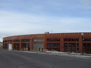
Union Pacific Railroad Complex (Evanston, Wyoming)
United States historic place
Distance: Approx. 603 meters
Latitude and longitude: 41.27111111,-110.96916667
The Union Pacific Railroad Complex in Evanston, Wyoming, was built to serve the Union Pacific Railroad main line running through Evanston. The complex's brick buildings were built in 1912–13, with frame buildings spanning the period from 1871 to the 1920s. The complex features a roundhouse with 27 stalls built during the 1912 improvement phase, replacing an earlier roundhouse built in 1871.
Weather in this IP's area
clear sky
17 Celsius
15 Celsius
15 Celsius
17 Celsius
1017 hPa
27 %
1017 hPa
800 hPa
10000 meters
06:57:58
19:45:03