Country:
 USA
USARegion:
City:
Latitude and Longitude:
Time Zone:
Postal Code:
IP information under different IP Channel
ip-api
Country
Region
City
ASN
Time Zone
ISP
Blacklist
Proxy
Latitude
Longitude
Postal
Route
IPinfo
Country
Region
City
ASN
Time Zone
ISP
Blacklist
Proxy
Latitude
Longitude
Postal
Route
MaxMind
Country
Region
City
ASN
Time Zone
ISP
Blacklist
Proxy
Latitude
Longitude
Postal
Route
Luminati
Country
USASN
Time Zone
America/Chicago
ISP
RFC2270-UUNET-CUSTOMER
Latitude
Longitude
Postal
db-ip
Country
Region
City
ASN
Time Zone
ISP
Blacklist
Proxy
Latitude
Longitude
Postal
Route
ipdata
Country
Region
City
ASN
Time Zone
ISP
Blacklist
Proxy
Latitude
Longitude
Postal
Route
Popular places and events near this IP address
Wildwood School
Private k-12 school in Los Angeles, California, United States
Distance: Approx. 634 meters
Latitude and longitude: 34.033527,-118.45117
Wildwood School is an independent progressive K–12 school located in Los Angeles. Wildwood was founded as an elementary school in 1971, by a group of parents led by a young lawyer named Belle Mason. The secondary campus (middle and high school) opened in 2000.

Sawtelle, Los Angeles
Neighborhood of Los Angeles, California, United States
Distance: Approx. 557 meters
Latitude and longitude: 34.03055556,-118.46333333
Sawtelle is a neighborhood in West Los Angeles, on the Westside of Los Angeles, California. The short-lived City of Sawtelle grew around the Pacific Branch of the National Home for Disabled Volunteer Soldiers, later the Sawtelle Veterans Home, and was incorporated as a city in 1899. Developed by the Pacific Land Company, and named for its manager W. E. Sawtelle, the City of Sawtelle was independent for fewer than 30 years before it was annexed by the City of Los Angeles.
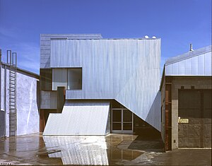
Bergamot (arts center)
Art gallery facility in Santa Monica, California, US
Distance: Approx. 978 meters
Latitude and longitude: 34.027677,-118.46652
Bergamot Station Arts Center is a Santa Monica facility housing many different private art galleries and appears in most tourist guides as a primary cultural destination. Opened September 17, 1994 as Bergamot Station the campus-like complex is owned by the city of Santa Monica and presently managed by the Worthe Group.
Poseidon School
Nonprofit, private, coeducational school in Los Angeles, CA, USA
Distance: Approx. 955 meters
Latitude and longitude: 34.0304,-118.4481
Poseidon School was a private, coeducational secondary day school located in Los Angeles, California. It was certified by the California Department of Education but closed c.2011.

McCabe's Guitar Shop
Musical instrument store and live music venue in Santa Monica, California, USA
Distance: Approx. 788 meters
Latitude and longitude: 34.02583333,-118.4575
McCabe's Guitar Shop is a musical instrument store and live music venue on Pico Boulevard in Santa Monica, California, United States. Opened in 1958 by Gerald L. McCabe, a well-known furniture designer. McCabe's specializes in acoustic and folk instruments, including guitars, banjos, mandolins, dulcimers, fiddles, ukuleles, psaltries, bouzoukis, sitars, ouds, and ethnic percussion.
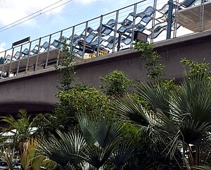
Expo/Bundy station
Los Angeles Metro Rail station
Distance: Approx. 501 meters
Latitude and longitude: 34.0316,-118.4528
Expo/Bundy station is an elevated light rail station in the Los Angeles Metro Rail system. It is located at the intersection of Bundy Drive and Exposition Boulevard in West Los Angeles, California. It serves the Metro E Line.

26th Street/Bergamot station
Light rail station
Distance: Approx. 1231 meters
Latitude and longitude: 34.0279,-118.4699
26th Street/Bergamot station is an at-grade light rail station in the Los Angeles Metro Rail system. It is located near the intersection of 26th Street and Olympic Boulevard in Santa Monica, California and near the Bergamot Station Arts Center. The station is served by the E Line.

Lighthouse Christian Academy
Private school in Santa Monica, California, United States
Distance: Approx. 1252 meters
Latitude and longitude: 34.034774,-118.471384
Lighthouse Christian Academy, in Santa Monica, California, is an American private, college preparatory Christian school founded in 1992 as an outgrowth of the Lighthouse Church School (founded in 1983). As of 2007, it is accredited by the International Christian Accrediting Association, an independent Christian educational association.
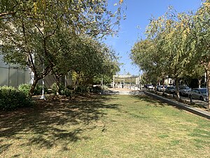
Ishihara Park
Park in Santa Monica, California, United States
Distance: Approx. 525 meters
Latitude and longitude: 34.029,-118.4612
Ishihara Park is a 2.35 acres (0.95 ha) linear community park located in Santa Monica, California. The park was opened to the public in February 2017 and is named after George Ishihara, a local resident who fought in World War II as part of the Japanese-American 442nd Regimental Combat Team and participated in the liberation of the Dachau concentration camp.

Gandara Park
Park in Santa Monica, California, United States
Distance: Approx. 882 meters
Latitude and longitude: 34.0275,-118.465
Gandara Park is a 3.8 acre residential park located in Santa Monica, California, United States.
Club 88
Music venue in Los Angeles
Distance: Approx. 1028 meters
Latitude and longitude: 34.03055556,-118.44722222
Club 88 was an all-ages live music venue that was a key part of the early Los Angeles punk scene in the late 1970s and early 1980s. Many seminal punk and New Wave groups got their start playing shows there.

Valentino (restaurant)
Defunct restaurant in Santa Monica, California, U.S.
Distance: Approx. 745 meters
Latitude and longitude: 34.02625,-118.45708333
Valentino was a restaurant in Santa Monica, California.
Weather in this IP's area
clear sky
30 Celsius
29 Celsius
24 Celsius
32 Celsius
1006 hPa
33 %
1006 hPa
1001 hPa
10000 meters
06:32:47
19:10:10