Country:
Region:
City:
Latitude and Longitude:
Time Zone:
Postal Code:
IP information under different IP Channel
ip-api
Country
Region
City
ASN
Time Zone
ISP
Blacklist
Proxy
Latitude
Longitude
Postal
Route
Luminati
Country
Region
ca
City
pattonvillage
ASN
Time Zone
America/Los_Angeles
ISP
PLUMAS-SIERRA-TELECOMMUNICATIONS
Latitude
Longitude
Postal
IPinfo
Country
Region
City
ASN
Time Zone
ISP
Blacklist
Proxy
Latitude
Longitude
Postal
Route
db-ip
Country
Region
City
ASN
Time Zone
ISP
Blacklist
Proxy
Latitude
Longitude
Postal
Route
ipdata
Country
Region
City
ASN
Time Zone
ISP
Blacklist
Proxy
Latitude
Longitude
Postal
Route
Popular places and events near this IP address

Herlong, California
Census-designated place in California, United States
Distance: Approx. 6356 meters
Latitude and longitude: 40.14361111,-120.13472222
Herlong is a census-designated place in Lassen County, California. Herlong is located at the extreme eastern edge of the Sierra Nevada Mountain Range in the southeastern region of Honey Lake Valley, 8 miles (13 km) north of Doyle, at an elevation of 4,114 feet (1,254 m). Its population is 237 as of the 2020 census, down from 298 from the 2010 census.

Federal Correctional Institution, Herlong
Medium-security United States prison in California
Distance: Approx. 4698 meters
Latitude and longitude: 40.15,-120.168
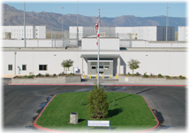
The Federal Correctional Institution, Herlong (FCI Herlong) is a medium-security United States federal prison for male inmates in California, opened in 2007. It is operated by the Federal Bureau of Prisons, a division of the United States Department of Justice. The facility also includes a satellite prison camp that houses minimum-security male offenders.
Patton Village, California
Census-designated place in California, United States
Distance: Approx. 5895 meters
Latitude and longitude: 40.14111111,-120.155
Patton Village is a census-designated place in Lassen County, California. It lies at an elevation of 4111 feet (1253 m). Its population is 632 as of the 2020 census, down from 702 from the 2010 census.
Rayl, California
Distance: Approx. 7462 meters
Latitude and longitude: 40.1386,-120.1214
Rayl (later Hackstaff) is a former town in Lassen County, California. It was located 9 miles (14 km) north of Doyle, 4200 feet east-southeast of present-day Herlong. It was named after Stanley Rayl, who built a hotel/store at the site in 1915.

Amedee Army Airfield
Airport in near Herlong, California
Distance: Approx. 8480 meters
Latitude and longitude: 40.26583333,-120.15055556
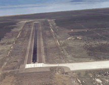
Amedee Army Airfield (IATA: AHC, ICAO: KAHC, FAA LID: AHC) is a military use airport located nine nautical miles (17 km) north of the central business district of Herlong, in Lassen County, California, United States. It is owned by the United States Army and located at the Sierra Army Depot in the Honey Lake Valley, east of the Sierra Nevada mountain range.

Sierra Army Depot
Airport in Sierra Army Depot, California
Distance: Approx. 8475 meters
Latitude and longitude: 40.26616389,-120.15261944
Sierra Army Depot (SIAD) is a United States Army post and military equipment storage facility located near the unincorporated community of Herlong, California. It was built in 1942 as one of several ammunition storage facilities located far enough inland to be safe from Japanese attack, yet close enough to western military posts and ports to facilitate shipment of supplies. The site also met the requirement that the depot be in a dry and isolated area.
Weather in this IP's area
clear sky
-1 Celsius
-4 Celsius
-1 Celsius
-1 Celsius
1027 hPa
67 %
1027 hPa
884 hPa
10000 meters
2.51 m/s
2.49 m/s
54 degree
8 %
06:36:34
16:52:10