Country:
Region:
City:
Latitude and Longitude:
Time Zone:
Postal Code:
IP information under different IP Channel
ip-api
Country
Region
City
ASN
Time Zone
ISP
Blacklist
Proxy
Latitude
Longitude
Postal
Route
Luminati
Country
Region
ar
City
pinebluff
ASN
Time Zone
America/Chicago
ISP
RITTERNET
Latitude
Longitude
Postal
IPinfo
Country
Region
City
ASN
Time Zone
ISP
Blacklist
Proxy
Latitude
Longitude
Postal
Route
db-ip
Country
Region
City
ASN
Time Zone
ISP
Blacklist
Proxy
Latitude
Longitude
Postal
Route
ipdata
Country
Region
City
ASN
Time Zone
ISP
Blacklist
Proxy
Latitude
Longitude
Postal
Route
Popular places and events near this IP address

Pine Bluff metropolitan area
Metropolitan Statistical Area in Arkansas, United States
Distance: Approx. 1817 meters
Latitude and longitude: 34.2,-92
The Pine Bluff Metropolitan Statistical Area, as defined by the United States Census Bureau, is a three-county region in southeast Arkansas, anchored by the city of Pine Bluff. As of the 2010 census, the MSA had a population of 100,258. The metro area's population declined by 12.47% between 2010 and 2020, more than any other metropolitan area in the United States.
Pine Bluff Convention Center
Distance: Approx. 2008 meters
Latitude and longitude: 34.22111111,-91.99777778
The Pine Bluff Convention Center is a convention center located in Pine Bluff, Arkansas at One Convention Center Plaza.

Area codes 870 and 327
Area code for eastern and southern Arkansas, United States
Distance: Approx. 1817 meters
Latitude and longitude: 34.2,-92
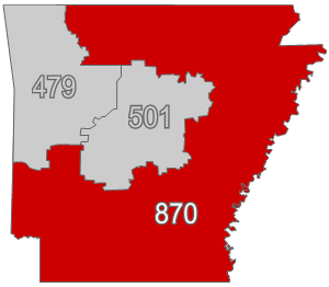
Area codes 870 and 327 are telephone area codes in the North American Numbering Plan (NANP) for southern, eastern, and most of northern Arkansas. 870 was created on April 14, 1997, in a split from area code 501, Arkansas's original area code of 1947, and 327 was added as part of an overlay complex in 2024.

Strengthen the Arm of Liberty Monument (Pine Bluff, Arkansas)
United States historic place
Distance: Approx. 2113 meters
Latitude and longitude: 34.21947222,-92.00108333
The Strengthen the Arm of Liberty Monument is a replica of the Statue of Liberty (Liberty Enlightening the World) in Pine Bluff Memorial Gardens, on the south side of 10th Avenue between Georgia and State Street in Pine Bluff, Arkansas. It was placed by the Boy Scouts of America (BSA) as part of its 1950s era campaign, "Strengthen the Arm of Liberty." The statue is 8 feet (2.4 m) in height, made of copper, and is mounted on concrete base 3.5 feet (1.1 m) tall. The statue faces north, toward the Pine Bluff Civic Center, and there is a bronze commemorative plaque on the north face of the base.
Floyd B. Brown House
Historic house in Arkansas, United States
Distance: Approx. 1887 meters
Latitude and longitude: 34.21722222,-92
The Floyd B. Brown House is a historic house at 1401 South Georgia Street in Pine Bluff, Arkansas. It is a single-story vernacular brick structure, with a gable roof and brick foundation. Decorative elements on the building are minimal, with scalloped trim elements at the gables and eaves, and a fanlight in the front-facing gable.

Nichol House
Historic house in Arkansas, United States
Distance: Approx. 1665 meters
Latitude and longitude: 34.21083333,-92.00055556
The Nichol House is a historic house at 205 Park Place in Pine Bluff, Arkansas. It is a two-story wood-frame structure, its exterior finished in a combination of brick veneer and stucco. A single-story shed-roofed porch extends across the front, supported by brick piers, with a second-story enclosed porch above the right side.
Dr. John Walter Parker Sr. House
Historic house in Arkansas, United States
Distance: Approx. 1834 meters
Latitude and longitude: 34.215,-92.00083333
The Dr. John Walter Parker Sr. House is a historic house at 1405 South Alabama Street in Pine Bluff, Arkansas.

Cotton Belt 336
Historic railroad steam locomotive
Distance: Approx. 2114 meters
Latitude and longitude: 34.22694444,-91.98444444
The St. Louis Southwestern Railway (Cotton Belt Route) Steam Locomotive #336 is a historic railroad steam locomotive, located at the Arkansas Railroad Museum in Pine Bluff, Arkansas. It is a Class D3 2-6-0 Mogul-style locomotive, built in 1909 by the Baldwin Locomotive Works in Philadelphia, Pennsylvania.

Taylor Field (Pine Bluff, Arkansas)
United States historic place
Distance: Approx. 1200 meters
Latitude and longitude: 34.21611111,-91.99138889
Taylor Field is a baseball stadium at 1201 East 16th Street in Pine Bluff, Arkansas. The stadium was built in 1939–40 with funding support from the Works Progress Administration and a design by local architect Mitchell Seligman. It was listed on the National Register of Historic Places in 2010.
St. Peter's Catholic School (Pine Bluff, Arkansas)
School
Distance: Approx. 1935 meters
Latitude and longitude: 34.2140572,-92.0024974
St. Peter's Catholic School (StPCS) was a Black Catholic school in Pine Bluff, Arkansas, in operation from 1889 through 1975 and 1985 through 2012.
KPBA (FM)
Radio station in Pine Bluff, Arkansas
Distance: Approx. 1727 meters
Latitude and longitude: 34.22111111,-91.97277778
KPBA is an FM radio station at 99.3 MHz in Pine Bluff, Arkansas. The station is owned by Bluff City Radio, a company of Mike Huckabee and Paul Coats, and operated by PB Radio under a local marketing agreement; it broadcasts an urban contemporary format known as 99-3 The Beat.
Saracen Casino Resort
Distance: Approx. 1667 meters
Latitude and longitude: 34.21065833,-91.96498056
Saracen Casino Resort is a casino in Pine Bluff, Arkansas, United States. The first purpose-built casino in Arkansas is owned by the Quapaw Nation, and named for Saracen, a Quapaw chief in the 1800s.
Weather in this IP's area
clear sky
17 Celsius
17 Celsius
17 Celsius
18 Celsius
1014 hPa
70 %
1014 hPa
1006 hPa
10000 meters
3.09 m/s
120 degree
06:42:26
17:03:27