Country:
Region:
City:
Latitude and Longitude:
Time Zone:
Postal Code:
IP information under different IP Channel
ip-api
Country
Region
City
ASN
Time Zone
ISP
Blacklist
Proxy
Latitude
Longitude
Postal
Route
Luminati
Country
ASN
Time Zone
America/Chicago
ISP
APPLIEDOPS
Latitude
Longitude
Postal
IPinfo
Country
Region
City
ASN
Time Zone
ISP
Blacklist
Proxy
Latitude
Longitude
Postal
Route
db-ip
Country
Region
City
ASN
Time Zone
ISP
Blacklist
Proxy
Latitude
Longitude
Postal
Route
ipdata
Country
Region
City
ASN
Time Zone
ISP
Blacklist
Proxy
Latitude
Longitude
Postal
Route
Popular places and events near this IP address

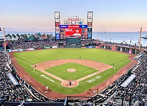
Oracle Park
Baseball park in San Francisco, California, US
Distance: Approx. 132 meters
Latitude and longitude: 37.77861111,-122.38916667
Oracle Park is a ballpark in the SoMa district of San Francisco, California. Since 2000, it has been the home of the San Francisco Giants of Major League Baseball (MLB). The stadium stands along San Francisco Bay; the section of the bay beyond Oracle Park's right field wall is unofficially known as McCovey Cove, in honor of former Giants player Willie McCovey.
California Institute for Regenerative Medicine
Research institute in California, United States
Distance: Approx. 288 meters
Latitude and longitude: 37.77795833,-122.392525
The California Institute for Regenerative Medicine (CIRM) is a state agency that supports research and education in the fields of stem cell and gene therapies. It was created in 2004 after 59% of California voters approved California Proposition 71: the Research and Cures Initiative, which allocated $3 billion to fund stem cell research in California. In 2020 voters approved Proposition 14 that allocated additional funds to CIRM. CIRM supports research and training at many stem cell institutes throughout California, including Sanford Consortium, University of California, Santa Cruz, Stanford University, University of California Davis, University of California Irvine, University of California San Francisco, University of California Los Angeles and University of Southern California.

McCovey Cove
Body of water in San Francisco Bay
Distance: Approx. 315 meters
Latitude and longitude: 37.77722222,-122.38805556
McCovey Cove is the unofficial name of a section of San Francisco Bay beyond the right field wall of Oracle Park, home of the San Francisco Giants, named after famed Giants first baseman Willie McCovey. The proper name for the cove is China Basin, which is the mouth of Mission Creek as it meets the bay. The cove is bounded along the north by Oracle Park, with a ferry landing and a breakwater at the northeast end.

South Park, San Francisco
Park and neighborhood in San Francisco, California
Distance: Approx. 396 meters
Latitude and longitude: 37.78138889,-122.39388889
South Park is a small urban park and eponymous neighborhood in the larger South of Market neighborhood of San Francisco, California, consisting of 0.85 acres (0.34 ha) of public ground. The neighborhood centers on the small, oval-shaped park and South Park Street, which encircles the park. South Park is bounded by Second, Third, Bryant, and Brannan streets.
King Street Garage
Distance: Approx. 126 meters
Latitude and longitude: 37.77888889,-122.39111111
The King Street Garage was a nightclub located at 174 King Street in San Francisco, California, near the present location of AT&T Park. It was directly adjacent to, and physically connected with, the Club Townsend, another famous nightclub on the other side of the block located at 177 Townsend Street.

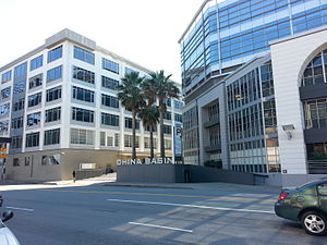
China Basin Landing
Office complex in San Francisco, California, United States
Distance: Approx. 397 meters
Latitude and longitude: 37.776348,-122.391839
China Basin Landing, now referred to as simply China Basin, is an office complex on the border of the South of Market (SoMa) and Mission Bay areas of San Francisco, California. The complex has 917,000 square feet (85,200 m2) of space. It is the headquarters of Lyft and Dignity Health.

Lefty O'Doul Bridge
Bridge in San Francisco
Distance: Approx. 327 meters
Latitude and longitude: 37.77666667,-122.39
The Lefty O'Doul Bridge (also known as the Third Street Bridge or China Basin Bridge) is a bascule bridge connecting the China Basin and Mission Bay neighborhoods of San Francisco, carrying Third Street across the Mission Creek Channel. It is located directly adjacent to Oracle Park.
Lydia (whaling bark)
United States historic place and shipwreck site
Distance: Approx. 201 meters
Latitude and longitude: 37.78083333,-122.38833333
The Lydia is a wrecked whaling ship located below the foot of King Street in San Francisco, California. The ship was built in 1840 and wrecked in 1907. San Francisco was later built up over the site of the wreck, and it was not rediscovered until a sewer construction project unearthed the remains in 1980.
Saison (restaurant)
Restaurant in California, United States
Distance: Approx. 198 meters
Latitude and longitude: 37.77952,-122.39225
Saison is a San Francisco restaurant that earned the highest rating of three stars from the Michelin Guide in 2014. It is located in the SoMa district. The founder is Beverage Director and Winemaker for Saison Winery, Mark Bright.
Steamboat Point
Distance: Approx. 199 meters
Latitude and longitude: 37.778,-122.389
Steamboat Point a headland marking the northeastern limit of Mission Bay, on San Francisco Bay. It was named for the shipyards that built and repaired steamboats there during the 1850s to the mid 1860s.

Statue of Willie McCovey
Statue of Willie McCovey in San Francisco, California, U.S.
Distance: Approx. 398 meters
Latitude and longitude: 37.77659,-122.38755
A statue of Baseball Hall of Fame player Willie McCovey was installed in McCovey Cove, San Francisco. It was unveiled in 2003 and was created by sculptor William Behrends. The statue was removed by San Francisco Giants and put into storage in July 2020 to keep it safe from any possible damage from construction work going on nearby.

Statue of Juan Marichal
Statue of Juan Marichal in San Francisco, California, U.S.
Distance: Approx. 398 meters
Latitude and longitude: 37.77659,-122.38755
A bronze statue of San Francisco Giants pitcher Juan Marichal was unveiled outside the main entrance of Oracle Park, in San Francisco, California on May 22, 2005. The Dominican-born Marichal is considered to be one of the greatest pitchers in the history of baseball, and was the winningest pitcher of the 1960s. The statue is located in front of the "Lefty O'Doul" entrance.
Weather in this IP's area
clear sky
14 Celsius
13 Celsius
12 Celsius
16 Celsius
1020 hPa
76 %
1020 hPa
1019 hPa
10000 meters
7.72 m/s
280 degree
06:38:41
17:07:34
