74.116.217.58 - IP Lookup: Free IP Address Lookup, Postal Code Lookup, IP Location Lookup, IP ASN, Public IP
Country:
 Canada
Region:
City:
Location:
Time Zone:
Postal Code:
ISP:
ASN:
language:
User-Agent:
Proxy IP:
Blacklist:
IP information under different IP Channel
ip-api
Country
Region
City
ASN
Time Zone
ISP
Blacklist
Proxy
Latitude
Longitude
Postal
Route
db-ip
Country
Region
City
ASN
Time Zone
ISP
Blacklist
Proxy
Latitude
Longitude
Postal
Route
IPinfo
Country
Region
City
ASN
Time Zone
ISP
Blacklist
Proxy
Latitude
Longitude
Postal
Route
IP2Location
74.116.217.58Country
caRegion
ontario
City
wyebridge
Time Zone
America/Toronto
ISP
Language
User-Agent
Latitude
Longitude
Postal
ipdata
Country
Region
City
ASN
Time Zone
ISP
Blacklist
Proxy
Latitude
Longitude
Postal
Route
Popular places and events near this IP address

Midland, Ontario
Town in Ontario, Canada
Distance: Approx. 5555 meters
Latitude and longitude: 44.75,-79.88333333
Midland is a town located on Georgian Bay in Simcoe County, Ontario, Canada. It is part of the Huronia/Wendat region of Central Ontario. Located at the southern end of Georgian Bay's 30,000 Islands, Midland is the economic centre of the region, with a 125-bed hospital and a local airport (Midland/Huronia Airport).
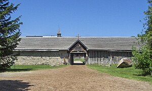
Sainte-Marie among the Hurons
Living museum in Ontario, Canada
Distance: Approx. 4825 meters
Latitude and longitude: 44.73416667,-79.84527778
Sainte-Marie among the Hurons (French: Sainte-Marie-au-pays-des-Hurons) was a French Jesuit settlement in Huronia or Wendake, the land of the Wendat, near modern Midland, Ontario, from 1639 to 1649. It was the first European settlement in what is now the province of Ontario. Eight missionaries from Sainte-Marie were martyred, and were canonized by the Catholic Church in 1930.

Shrine of the Canadian Martyrs
Church in Ontario, Canada
Distance: Approx. 5196 meters
Latitude and longitude: 44.73661,-79.84208
The Shrine of the Canadian Martyrs (French: Sanctuaire des martyrs canadiens), commonly known as the Martyrs' Shrine, is a Roman Catholic and historic place of worship located near Georgian Bay on Ontario Highway 12 in Midland, Ontario, Canada. The Martyrs' Shrine is consecrated to the memory of the Canadian Martyrs, six Jesuit Martyrs and two lay persons from the mission of Sainte-Marie among the Hurons, who were tortured and killed on various dates in the mid-17th century and subsequently canonized by the Catholic Church. It is one of six national shrines in Canada, including, among others, Saint Joseph's Oratory in Montreal and the Basilica of Sainte-Anne-de-Beaupré.
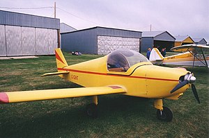
Zenair
Canadian homebuilt aircraft manufacturer
Distance: Approx. 4080 meters
Latitude and longitude: 44.69111111,-79.93298611
Zenair Ltd is a Canadian kit aircraft producer founded by aeronautical engineer Chris Heintz and based in Midland, Ontario.

Midland/Huronia Airport
Airport in Ontario, Canada
Distance: Approx. 4055 meters
Latitude and longitude: 44.68472222,-79.92944444
Midland/Huronia Airport (ICAO: CYEE) is located 4 nautical miles (7.4 km; 4.6 mi) south southwest of Midland, Ontario, Canada. The Huronia Airport is co-owned by Tiny Township, Penetanguishene, and Midland, The airport features a 3,996-foot runway (similar to Buttonville and Toronto Island) that can accommodate most multi-engine turboprop aircraft and numerous small-to-medium-sized executive jets. It also has a 75,950 sq.

Wyevale (Boker Field) Airport
Airport in Wyevale, Ontario
Distance: Approx. 5000 meters
Latitude and longitude: 44.65527778,-79.87888889
Wyevale (Boker Field) Airport (TC LID: CNL8) is located 2 nautical miles (3.7 km; 2.3 mi) east of Wyevale, Ontario, Canada.
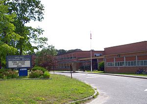
Georgian Bay District Secondary School
High school in Midland, Ontario, Canada
Distance: Approx. 5035 meters
Latitude and longitude: 44.7438,-79.8994
Georgian Bay District SS ("GBDSS") is a Public high school in Midland, Simcoe County, in Central Ontario, Canada. Students attend from Midland/Penetanguishene and surrounding areas including Hillsdale, Port McNicoll, Waubaushene, Victoria Harbour, Honey Harbour, Wyevale and Christian Island. The principal is Hailey McLean.
Huronia Museum
History museum and heritage village in Ontario, Canada
Distance: Approx. 4677 meters
Latitude and longitude: 44.7421,-79.8813
The Huronia Museum is located in Midland, Ontario, Canada. The museum consists of the museum building (housing collections and art gallery) and the Huron/Ouendat (Wendat) village (palisade and longhouse). The museum is open year-round and has nearly one million objects and receives some 20,000 visitors each year.

Wye Marsh
Distance: Approx. 3196 meters
Latitude and longitude: 44.71666667,-79.85
The Wye Marsh is a wetland area on the south shores of Georgian Bay in Ontario, Canada. The Wye Marsh National Wildlife Area was established on the location in 1978. It is designated a Provincially Significant Wetland by the Ontario Ministry of Natural Resources.
Saint Theresa's High School
High school in Canada
Distance: Approx. 4444 meters
Latitude and longitude: 44.73891,-79.86983
St. Theresa's High School is a high school in Midland, Ontario, Canada administered by the Simcoe Muskoka Catholic District School Board. The school serves students from Midland, Penetanguishene, Tay Township, Tiny Township and a portion of Springwater Township (Elmvale).

Huronia (region)
Historical region between the Great Lakes of North America
Distance: Approx. 4075 meters
Latitude and longitude: 44.686962,-79.931059
Huronia (Wendat: Wendake) is a historical region in the province of Ontario, Canada. It is positioned between lakes Simcoe, Ontario, and Huron. Similarly to the latter, it takes its name from the Wendat or Huron, an Iroquoian-speaking people, who lived there from prehistoric times until 1649 during the Beaver Wars when they were defeated and displaced by the Five Nations of the Iroquois who lived in New York.

Midland Cultural Centre
Building in Ontario, Canada
Distance: Approx. 5397 meters
Latitude and longitude: 44.748585,-79.883278
The Midland Cultural Centre is a public multi-use complex located in Midland, Ontario, Canada. The 2787 m2 (30 000 sq ft) building is home to three main groups: Quest Art School and Gallery, the Huronia Players theatre company, and Rotary Hall, a community event space. The Midland Cultural Centre was designed by Howard Rideout of Howard Rideout Architect (HRA), in collaboration with IHD Design Build.
Weather in this IP's area
overcast clouds
-18 Celsius
-22 Celsius
-18 Celsius
-18 Celsius
1033 hPa
100 %
1033 hPa
1004 hPa
4955 meters
1.41 m/s
1.43 m/s
85 degree
100 %