74.116.122.149 - IP Lookup: Free IP Address Lookup, Postal Code Lookup, IP Location Lookup, IP ASN, Public IP
Country:
Region:
City:
Location:
Time Zone:
Postal Code:
IP information under different IP Channel
ip-api
Country
Region
City
ASN
Time Zone
ISP
Blacklist
Proxy
Latitude
Longitude
Postal
Route
Luminati
Country
ASN
Time Zone
America/Toronto
ISP
RACK-AND-DATA
Latitude
Longitude
Postal
IPinfo
Country
Region
City
ASN
Time Zone
ISP
Blacklist
Proxy
Latitude
Longitude
Postal
Route
IP2Location
74.116.122.149Country
Region
ontario
City
guelph
Time Zone
America/Toronto
ISP
Language
User-Agent
Latitude
Longitude
Postal
db-ip
Country
Region
City
ASN
Time Zone
ISP
Blacklist
Proxy
Latitude
Longitude
Postal
Route
ipdata
Country
Region
City
ASN
Time Zone
ISP
Blacklist
Proxy
Latitude
Longitude
Postal
Route
Popular places and events near this IP address

Guelph (federal electoral district)
Federal electoral district in Ontario, Canada
Distance: Approx. 402 meters
Latitude and longitude: 43.55,-80.25
Guelph (formerly Guelph—Wellington) is a federal electoral district in Ontario, Canada, that has been represented in the House of Commons of Canada since 1979. This riding has had a Liberal MP since 1993. From 2008 until his decision not to run in 2015, the riding's parliamentary seat was held by Liberal MP Frank Valeriote.
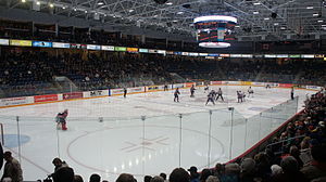
Sleeman Centre
Sporting and entertainment facility located in Guelph, Ontario
Distance: Approx. 672 meters
Latitude and longitude: 43.54666667,-80.24638889
The Sleeman Centre (formerly the Guelph Sports and Entertainment Centre) is a 4,715 seat multi-purpose facility in Guelph, Ontario, Canada. The Sleeman Centre has hosted concerts, sporting and family events as well as trade shows and conferences. It is home to the Guelph Storm of the major junior Ontario Hockey League.

Guelph Central Station
Railway station in Ontario, Canada
Distance: Approx. 950 meters
Latitude and longitude: 43.54416667,-80.24694444
Guelph Central Station (also known as Guelph Central GO Station) is the main inter-modal transportation terminal in Guelph, Ontario, Canada. It is used by Via Rail and GO Transit trains, as well as Guelph Transit local buses, GO Transit regional buses and intercity buses. It is located at 79 Carden Street and includes the historic Guelph Railway Station, as well as the site of the former Guelph Bus Terminal.

Wellington Catholic District School Board
Distance: Approx. 561 meters
Latitude and longitude: 43.5477,-80.24757
The Wellington Catholic District School Board is a school board in Ontario, Canada, serving the students of the City of Guelph and Wellington County. There are 4 high schools and 18 elementary schools serving roughly 8000 students.

Downtown Guelph
Central business district of Guelph, Ontario, Canada
Distance: Approx. 790 meters
Latitude and longitude: 43.54583333,-80.24916667
Downtown Guelph is the central business district of Guelph, Ontario, Canada. It is bordered by Wellington St. E. to the south, Woolwich St.

Guelph (provincial electoral district)
Provincial electoral district in Ontario, Canada
Distance: Approx. 402 meters
Latitude and longitude: 43.55,-80.25
Guelph is a provincial electoral district in southwestern Ontario, Canada. It has been represented in the Legislative Assembly of Ontario from 1987 until 1999, and again from 2007 to present. The riding was created from portions of the Guelph—Wellington riding.
Guelph Bus Terminal
Bus station in Guelph, Ontario, Canada
Distance: Approx. 777 meters
Latitude and longitude: 43.54577778,-80.2455
The Guelph Bus Terminal was the main intercity bus station in Guelph, Ontario until May 13, 2012, when it was replaced by Guelph Central Station. Operators using the terminal included Aboutown, GO Transit and Greyhound. Coach Canada also served the station until early 2010.

Guelph General Hospital
Hospital in Guelph, Ontario, Canada
Distance: Approx. 676 meters
Latitude and longitude: 43.556223,-80.253528
Guelph General Hospital is a medical care facility in Guelph, Ontario, Canada. It is a 182-bed facility with a total staff of about 1600. The facility opened as a 12-bed unit on 16 August 1875.

River Run Centre
Performing arts centre in Guelph, Ontario, Canada
Distance: Approx. 557 meters
Latitude and longitude: 43.54771,-80.24616
The River Run Centre is a performing arts centre in Guelph, Ontario, Canada. Construction of the facility began in 1995 and cost $15 million. It officially opened on October 4, 1997.

Allan's Mill
Former watermill in Guelph, Ontario, Canada
Distance: Approx. 712 meters
Latitude and longitude: 43.5468,-80.2433
Allan's Mill was a watermill located on both banks of the Speed River in Guelph, Ontario, Canada. Part of the site is now listed under the Ontario Heritage Act.

Old Quebec Street Mall
Shopping mall in Ontario, Canada
Distance: Approx. 735 meters
Latitude and longitude: 43.54615,-80.24788
Old Quebec Street Shoppes & Office Suites is a commercial mixed use building located on Wyndham Street North in downtown Guelph, Ontario, Canada. The main entrance faces the intersection of Quebec Street and Wyndham Street at St. Georges Square.

Guelph Public Library
Public library system in Guelph, Canada
Distance: Approx. 935 meters
Latitude and longitude: 43.5456,-80.2529
Guelph Public Library is a public library system serving the city of Guelph, Ontario, Canada. The main library downtown, five branches, and a bookmobile (seven branches total) serve about 123,000 residents in Guelph. The current CEO is Dan Atkins.
Weather in this IP's area
broken clouds
2 Celsius
-3 Celsius
1 Celsius
2 Celsius
1023 hPa
78 %
1023 hPa
981 hPa
10000 meters
6.17 m/s
100 degree
75 %

