74.116.121.236 - IP Lookup: Free IP Address Lookup, Postal Code Lookup, IP Location Lookup, IP ASN, Public IP
Country:
Region:
City:
Location:
Time Zone:
Postal Code:
ISP:
ASN:
language:
User-Agent:
Proxy IP:
Blacklist:
IP information under different IP Channel
ip-api
Country
Region
City
ASN
Time Zone
ISP
Blacklist
Proxy
Latitude
Longitude
Postal
Route
db-ip
Country
Region
City
ASN
Time Zone
ISP
Blacklist
Proxy
Latitude
Longitude
Postal
Route
IPinfo
Country
Region
City
ASN
Time Zone
ISP
Blacklist
Proxy
Latitude
Longitude
Postal
Route
IP2Location
74.116.121.236Country
Region
ontario
City
kitchener
Time Zone
America/Toronto
ISP
Language
User-Agent
Latitude
Longitude
Postal
ipdata
Country
Region
City
ASN
Time Zone
ISP
Blacklist
Proxy
Latitude
Longitude
Postal
Route
Popular places and events near this IP address

Kitchener, Ontario
City in Ontario, Canada
Distance: Approx. 1464 meters
Latitude and longitude: 43.41861111,-80.47277778
Kitchener is a city in the Canadian province of Ontario, about 100 km (62 mi) west of Toronto. It is one of three cities that make up the Regional Municipality of Waterloo and is the regional seat. Kitchener was known as Berlin until a 1916 referendum changed its name.
St. Mary's High School (Kitchener)
High school in Kitchener, Ontario, Canada
Distance: Approx. 1815 meters
Latitude and longitude: 43.420036,-80.467431
St. Mary's High School is a Catholic secondary school in Kitchener, Ontario, Canada. It serves most of Kitchener's Catholic students, with others attending Resurrection Catholic Secondary School.
Cameron Heights Collegiate Institute
High school in Kitchener, Ontario, Canada
Distance: Approx. 2336 meters
Latitude and longitude: 43.44458056,-80.48168889
Cameron Heights Collegiate Institute is a public secondary school in Kitchener, Ontario, run by the Waterloo Region District School Board. It is part of the International Baccalaureate (IB) program. The school is located at 301 Charles St.

Rockway Mennonite Collegiate
Private school in Kitchener, Ontario, Canada
Distance: Approx. 2395 meters
Latitude and longitude: 43.4357,-80.46397
Rockway Mennonite Collegiate (RMC) is an independent Mennonite high school located in Kitchener, Ontario, Canada. It offers academic programs for grade 7–12 students, various cross-cultural exchanges, as well as arts, athletics and tech programs. Approximately 40% of its 300-student population are Mennonite, coming from the modern Canadian Mennonite church, rather than Old Order Mennonites.

St. Mary's General Hospital
Hospital in Ontario, Canada
Distance: Approx. 1818 meters
Latitude and longitude: 43.437807,-80.50174
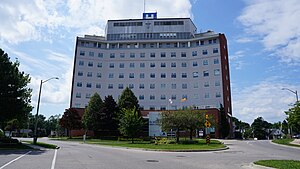
St. Mary's General Hospital is a 197-bed adult acute-care facility in Kitchener, Ontario, Canada serving Waterloo Region and surrounding area. St.
Forest Heights Collegiate Institute
Secondary school in Kitchener, Ontario, Canada
Distance: Approx. 2603 meters
Latitude and longitude: 43.42568889,-80.52123889
Forest Heights Collegiate Institute (FHCI), shortened as Forest Heights or simply Forest, is a high school in Kitchener, Ontario, Canada that was established in 1964. It is run by the Waterloo Region District School Board (WRDSB). As of the 2024–2025 school year, Forest Heights has approximately 1200 students.

Schneider Haus
House in Kitchener, Canada
Distance: Approx. 2303 meters
Latitude and longitude: 43.4446,-80.4946
The Schneider Haus National Historic Site, formerly Joseph Schneider Haus, is a museum in Kitchener, Ontario, Canada. Situated on some of the earliest land to be settled by non-Indigenous peoples in what would become Waterloo County, the museum includes the oldest remaining dwelling in the area and was named a National Historic Site of Canada in 1999.

Kitchener Market station
Light rail station in Kitchener, Ontario
Distance: Approx. 2499 meters
Latitude and longitude: 43.44638889,-80.48361111
Kitchener Market is a stop on the Ion rapid transit system in the Region of Waterloo in Ontario, Canada. It is located in the Cedar Hill neighbourhood at the intersection of Charles and Cedar streets, about 100 metres (330 ft) south of its namesake, the Kitchener Farmer's Market. The station initially had a working name of Cedar, and it opened in 2019.

Borden station
Light rail station in Kitchener, Ontario
Distance: Approx. 2303 meters
Latitude and longitude: 43.44228,-80.47501
Borden is a stop on the Region of Waterloo's Ion rapid transit system. It is located in the median of Charles Street in Kitchener, at Borden Avenue. It opened in 2019.

Mill station
Light rail station in Kitchener, Ontario
Distance: Approx. 1380 meters
Latitude and longitude: 43.43395,-80.47839
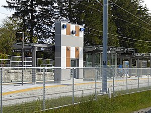
Mill is a stop on the Region of Waterloo's Ion rapid transit system. It is located southeast of the intersection of Ottawa and Mill Streets in Kitchener, alongside the CN Huron Subdivision. It opened on June 21, 2019.

Block Line station
Light rail station in Kitchener, Ontario
Distance: Approx. 2148 meters
Latitude and longitude: 43.4226,-80.46263
Block Line is a stop on the Region of Waterloo's Ion rapid transit system. It is located alongside Courtland Avenue in Kitchener, just north of Block Line Road. It opened on June 21, 2019.
Sunrise Centre
Bus terminal in Kitchener, Ontario
Distance: Approx. 2479 meters
Latitude and longitude: 43.415324,-80.517165
The Sunrise Centre Station is a bus station and terminal in Kitchener, Ontario, Canada. The station is a single platform with bus bays on each side. The platform has a heated shelter with seats inside, LED real-time displays and map boards.
Weather in this IP's area
light snow
-3 Celsius
-10 Celsius
-4 Celsius
-3 Celsius
1001 hPa
94 %
1001 hPa
961 hPa
2816 meters
10.29 m/s
13.38 m/s
310 degree
100 %

