74.116.120.137 - IP Lookup: Free IP Address Lookup, Postal Code Lookup, IP Location Lookup, IP ASN, Public IP
Country:
Region:
City:
Location:
Time Zone:
Postal Code:
IP information under different IP Channel
ip-api
Country
Region
City
ASN
Time Zone
ISP
Blacklist
Proxy
Latitude
Longitude
Postal
Route
Luminati
Country
ASN
Time Zone
America/Toronto
ISP
RACK-AND-DATA
Latitude
Longitude
Postal
IPinfo
Country
Region
City
ASN
Time Zone
ISP
Blacklist
Proxy
Latitude
Longitude
Postal
Route
IP2Location
74.116.120.137Country
Region
ontario
City
paris
Time Zone
America/Toronto
ISP
Language
User-Agent
Latitude
Longitude
Postal
db-ip
Country
Region
City
ASN
Time Zone
ISP
Blacklist
Proxy
Latitude
Longitude
Postal
Route
ipdata
Country
Region
City
ASN
Time Zone
ISP
Blacklist
Proxy
Latitude
Longitude
Postal
Route
Popular places and events near this IP address
Paris, Ontario
Unincorporated community in Ontario, Canada
Distance: Approx. 165 meters
Latitude and longitude: 43.19333333,-80.38472222
Paris (2021 population, 14,956) is a community located in the County of Brant, Ontario, Canada. It lies just northwest from the city of Brantford at the spot where the Nith River empties into the Grand River. Paris was voted "the Prettiest Little Town in Canada" by Harrowsmith Magazine.
County of Brant
City in Ontario, Canada
Distance: Approx. 8824 meters
Latitude and longitude: 43.11666667,-80.36666667
The County of Brant (2021 population 39,474) is a single-tier municipality in the Canadian province of Ontario. Although it retains the word "county" in its name, the municipality is a single-tier municipal government and has no upper tier. The County of Brant has service offices in Burford, Paris, Oakland, Onondaga and St.

Paris District High School
School in Paris, Ontario, Canada
Distance: Approx. 1016 meters
Latitude and longitude: 43.20392,-80.38557
Paris District High School (PDHS) is a regional high school in Paris, Ontario, Canada. The school was built in 1923, replacing the previous grammar school which had been built in 1858, and was known officially as Paris High School until a large addition was constructed in the late 1960s. In 2004, PDHS served students from Paris and other towns found in the immediate area, including St.

Barker's Bush
Distance: Approx. 1011 meters
Latitude and longitude: 43.19305556,-80.39722222
Barker's Bush is a forest located in the Grand River watershed near the banks of the Nith River in the community of Paris, County of Brant, Ontario, Canada. The bush is directly north and west of Lion's Park, and less than one kilometre northwest of the confluence of the Nith and the Grand rivers. Consisting of a mix of both coniferous and deciduous trees common to the Carolinian forests of southwestern Ontario, the bush itself is riddled with extensive bike and hiking trails which are used frequently, especially so through the warmer months (typically late Spring through early Fall).

Nith River
River in Ontario, Canada
Distance: Approx. 327 meters
Latitude and longitude: 43.1925,-80.3825
The Nith River is a river in Brant, Oxford and Perth counties and the Regional Municipality of Waterloo in Southwestern Ontario, Canada. The Nith River is approximately 125km in length and empties into the Grand River at the town of Paris. It is named after the River Nith in Scotland.

W. Ross Macdonald School
School in Brantford, Ontario, Canada
Distance: Approx. 9423 meters
Latitude and longitude: 43.15257,-80.2844
The W. Ross Macdonald School was founded in March 1872 in Brantford, Ontario, Canada. Its first principal was Ezekiel Stone Wiggins. It provides instruction from kindergarten to secondary school graduation for blind and deafblind students.

CKBT-FM
Radio station in Kitchener, Ontario
Distance: Approx. 8766 meters
Latitude and longitude: 43.26083333,-80.44388889
CKBT-FM is a Canadian radio station broadcasting at 91.5 FM in Kitchener, Ontario. The station broadcasts a CHR/Top 40 format branded as 91.5 The Beat, with studios & offices located in Kitchener, However, its transmitter is south of Ayr. The station is owned by Corus Entertainment.

Brantford Airport
Airport in Brantford, Ontario
Distance: Approx. 7787 meters
Latitude and longitude: 43.1325,-80.34138889
Brantford Airport (ICAO: CYFD), also known as Brantford Municipal Airport, is a registered aerodrome located 4 nautical miles (7.4 km; 4.6 mi) west southwest of the City of Brantford, in the county of Brant, Ontario, Canada. There is a single fixed-base operator at the airport. The airport hosts a widely attended air show every year at the end of August, featuring the Royal Canadian Air Force aerobatic team the Snowbirds and airplanes from the Canadian Warplane Heritage Museum.
CKPC-FM
Radio station in Brantford, Ontario
Distance: Approx. 9852 meters
Latitude and longitude: 43.26361111,-80.30861111
CKPC-FM (92.1 FM, Lite 92) is a radio station in Brantford, Ontario. Owned by Evanov Communications, it broadcasts a soft adult contemporary format, billed as "Southern Ontario's Favourites". The studios are located at 325 West St in Brantford while its transmitter located near Brant Rd 24 and McLean School Rd north of Brantford.
CJIQ-FM
Radio station at Conestoga College in Kitchener, Ontario
Distance: Approx. 8766 meters
Latitude and longitude: 43.26083333,-80.44388889
CJIQ-FM, is a Canadian radio station based in Kitchener, Ontario. It is the campus radio station of the city's Conestoga College.

Brantford Golf & Country Club
Distance: Approx. 8096 meters
Latitude and longitude: 43.16027778,-80.29722222
The Brantford Golf & Country Club is a private golf course and former curling club located in Brantford, Ontario, Canada. It is the fourth oldest golf club in North America having been founded in 1879. The course is ranked 46 in 2010 Scoregolf Top 100 Courses in Canada.

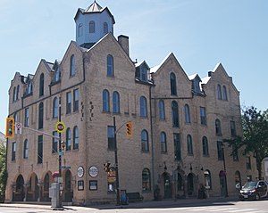
Arlington Hotel (Paris, Ontario)
Historic hotel in Paris, Ontario
Distance: Approx. 80 meters
Latitude and longitude: 43.1941,-80.3848
The Arlington Hotel is a historic hotel in Paris, Ontario. Built in the early 1850s by O.B. Bradford, it was first known as the Bradford House/Hotel. The Ealand family, who took over the house in 1882 after O.B. Bradford's sudden death, and renamed it the Arlington.
Weather in this IP's area
overcast clouds
2 Celsius
-2 Celsius
2 Celsius
3 Celsius
1022 hPa
84 %
1022 hPa
989 hPa
10000 meters
4.69 m/s
8.6 m/s
84 degree
100 %

