74.114.110.69 - IP Lookup: Free IP Address Lookup, Postal Code Lookup, IP Location Lookup, IP ASN, Public IP
Country:
Region:
City:
Location:
Time Zone:
Postal Code:
IP information under different IP Channel
ip-api
Country
Region
City
ASN
Time Zone
ISP
Blacklist
Proxy
Latitude
Longitude
Postal
Route
Luminati
Country
Region
la
City
gray
ASN
Time Zone
America/Chicago
ISP
GLOBALDATASYSTEMS-ASN
Latitude
Longitude
Postal
IPinfo
Country
Region
City
ASN
Time Zone
ISP
Blacklist
Proxy
Latitude
Longitude
Postal
Route
IP2Location
74.114.110.69Country
Region
pennsylvania
City
pittston
Time Zone
America/New_York
ISP
Language
User-Agent
Latitude
Longitude
Postal
db-ip
Country
Region
City
ASN
Time Zone
ISP
Blacklist
Proxy
Latitude
Longitude
Postal
Route
ipdata
Country
Region
City
ASN
Time Zone
ISP
Blacklist
Proxy
Latitude
Longitude
Postal
Route
Popular places and events near this IP address

Hughestown, Pennsylvania
Borough in Pennsylvania, United States
Distance: Approx. 1715 meters
Latitude and longitude: 41.32722222,-75.77527778
Hughestown is a borough in the Greater Pittston area of Luzerne County, Pennsylvania, United States. The population was 1,326 at the 2020 census.

Pittston, Pennsylvania
City in Pennsylvania, United States
Distance: Approx. 729 meters
Latitude and longitude: 41.32388889,-75.78888889
Pittston is a city in Luzerne County, Pennsylvania, United States. The city lies in the Wyoming Valley on the east side of the Susquehanna River and on the south side of the Lackawanna River. It is approximately midway between Wilkes-Barre and Scranton.

West Pittston, Pennsylvania
Borough in Pennsylvania, United States
Distance: Approx. 1451 meters
Latitude and longitude: 41.32926389,-75.79904722
West Pittston is a borough in the Greater Pittston area of Luzerne County, Pennsylvania, United States. It is located on the Susquehanna River (opposite of Pittston City). In 2020, the population was 4,644.

Yatesville, Pennsylvania
Borough in Pennsylvania, United States
Distance: Approx. 1808 meters
Latitude and longitude: 41.30305556,-75.78166667
Yatesville is a borough in the Greater Pittston area of Luzerne County, Pennsylvania. The population was 638 as of the 2020 census.

Battle of Wyoming
Part of the American Revolutionary War
Distance: Approx. 2330 meters
Latitude and longitude: 41.32055556,-75.81888889
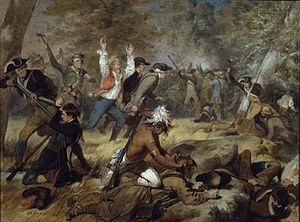
The Battle of Wyoming, also known as the Wyoming Massacre, was a military engagement during the American Revolutionary War between Patriot militia and a force of Loyalist soldiers and Iroquois warriors. The battle took place in the Wyoming Valley of Pennsylvania on July 3, 1778, in what is now Luzerne County. The result was an overwhelming defeat for the Americans.

Wyoming Area School District
Pennsylvania public school district
Distance: Approx. 1669 meters
Latitude and longitude: 41.32358,-75.80961
The Wyoming Area School District is a midsized, suburban, public school district that is located in northeastern Luzerne County and southeastern Wyoming County, Pennsylvania. It is situated midway between Wilkes-Barre and Scranton. One of the 500 public school districts of Pennsylvania, this district is composed of six municipalities: West Pittston, Exeter, Wyoming, West Wyoming, Harding and Falls Township, covering approximately 26 square miles (67 km2) primarily in Luzerne County.

Greater Pittston
Region in Pennsylvania, United States
Distance: Approx. 729 meters
Latitude and longitude: 41.32388889,-75.78888889
Greater Pittston is a 65.35 sq mi (169.3 km2) region in Luzerne County, Pennsylvania, in reference to the area in and around Pittston. As of 2010, the total population of Greater Pittston is 48,020. This region includes Avoca, Dupont, Duryea, Exeter Boro, Exeter Township, Hughestown, Jenkins Township, Laflin, Pittston Township, West Pittston, West Wyoming, Wyoming, and Yatesville.

Saint John the Baptist Elementary School, Pittston
Defunct Catholic school in Pennsylvania, USA
Distance: Approx. 679 meters
Latitude and longitude: 41.32357,-75.78962
Saint John the Baptist Elementary School was a Catholic school located on William Street in Pittston City, Luzerne County, Pennsylvania, United States. It was named after the neighboring church (which was first opened in 1892 by Slovak immigrants). Its pastors were Rev.

Port Griffith, Pennsylvania
Unincorporated community in Pennsylvania, United States
Distance: Approx. 1777 meters
Latitude and longitude: 41.31083333,-75.81055556
Port Griffith is an unincorporated community found within the Greater Pittston metropolitan area of Jenkins Township, Luzerne County, Pennsylvania, United States.

Firefighters' Memorial Bridge (Pittston, Pennsylvania)
Bridge in Pennsylvania, United States
Distance: Approx. 766 meters
Latitude and longitude: 41.32437,-75.79295
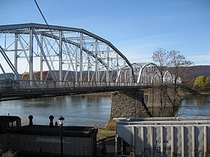
Water Street Bridge is a truss bridge that spans the Susquehanna River between West Pittston, Pennsylvania and Pittston, Pennsylvania. It was built in 1914 by the Penn Bridge Company.

Pittston Area High School
Public school in the United States
Distance: Approx. 1636 meters
Latitude and longitude: 41.30305,-75.79409
Pittston Area High School is a public high school located near Pittston, Pennsylvania. The building itself straddles the border of Jenkins Township and Yatesville. The school is part of the Pittston Area School District and it serves about 1,100 students in grades 9 to 12.
Browntown, Luzerne County, Pennsylvania
Census-designated place in Pennsylvania, United States
Distance: Approx. 720 meters
Latitude and longitude: 41.31277778,-75.78555556
Browntown is a census-designated place (CDP) in Pittston Township, Luzerne County, Pennsylvania, United States, adjacent to Pittston City. The CDP population was 1,418 at the 2010 census.
Weather in this IP's area
overcast clouds
-3 Celsius
-3 Celsius
-4 Celsius
-1 Celsius
1014 hPa
62 %
1014 hPa
989 hPa
10000 meters
0.45 m/s
4.92 m/s
346 degree
100 %