74.113.228.70 - IP Lookup: Free IP Address Lookup, Postal Code Lookup, IP Location Lookup, IP ASN, Public IP
Country:
 USA
USARegion:
City:
Location:
Time Zone:
Postal Code:
ISP:
ASN:
language:
User-Agent:
Proxy IP:
Blacklist:
IP information under different IP Channel
ip-api
Country
Region
City
ASN
Time Zone
ISP
Blacklist
Proxy
Latitude
Longitude
Postal
Route
db-ip
Country
Region
City
ASN
Time Zone
ISP
Blacklist
Proxy
Latitude
Longitude
Postal
Route
IPinfo
Country
Region
City
ASN
Time Zone
ISP
Blacklist
Proxy
Latitude
Longitude
Postal
Route
IP2Location
74.113.228.70Country
usRegion
north carolina
City
raleigh
Time Zone
America/New_York
ISP
Language
User-Agent
Latitude
Longitude
Postal
ipdata
Country
Region
City
ASN
Time Zone
ISP
Blacklist
Proxy
Latitude
Longitude
Postal
Route
Popular places and events near this IP address

Athens Drive High School
Public school in North Carolina, United States
Distance: Approx. 1706 meters
Latitude and longitude: 35.7687,-78.7112
Athens Drive Magnet High School, formerly known as Athens Drive High School, is a secondary Wake County public high school in southwestern Raleigh, North Carolina, that serves grades 9–12. As of 2023–2024, the school has 2,062 enrolled students and approximately 127 hired educators. It is also part of the Wake County Public School System.

Wake County Public School System
School district in North Carolina, United States
Distance: Approx. 1561 meters
Latitude and longitude: 35.75403056,-78.73713056
The Wake County Public School System (WCPSS) is a public school district located in Wake County, North Carolina. With 159,995 students in average daily membership and 198 schools as of the 2023–24 school year, it is the largest public school district in North Carolina and 14th-largest in the United States as of 2016.
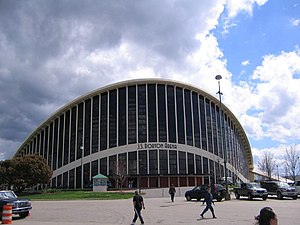
Dorton Arena
Arena in Raleigh, North Carolina, US
Distance: Approx. 4379 meters
Latitude and longitude: 35.79361111,-78.71
J. S. Dorton Arena is a 7,610-seat multi-purpose arena located in Raleigh, North Carolina, on the grounds of the North Carolina State Fair. It opened in 1952. Architect Maciej Nowicki of the North Carolina State University Department of Architecture was killed in an airplane crash before the construction phase.

Centennial Campus of North Carolina State University
Distance: Approx. 4343 meters
Latitude and longitude: 35.771,-78.676
Centennial Campus is a research park and educational campus owned and operated by North Carolina State University in Raleigh, North Carolina, United States. Composed of two locations, the 1,334 acres (5.4 km2) property provides office and lab space for corporate, governmental and not-for-profit entities, in addition to providing space for 75 university research centers, institutes, laboratories and departmental units. Currently, 5,000,000 sq ft (460,000 m2) of constructed space has been built.

Cary Towne Center
Former shopping mall in North Carolina, US
Distance: Approx. 4070 meters
Latitude and longitude: 35.773153,-78.759087
Cary Towne Center was an indoor shopping mall in Cary, North Carolina. It was anchored by Belk, Dillard's, Macy's, JCPenney, and Sears.

Lonnie Poole Golf Course
Golf course in Raleigh, North Carolina, United States
Distance: Approx. 3865 meters
Latitude and longitude: 35.76015,-78.67757
Lonnie Poole Golf Course is an 18-hole public golf course located on the campus of North Carolina State University in Raleigh, North Carolina, United States.

Crossroads Plaza (North Carolina)
Distance: Approx. 1770 meters
Latitude and longitude: 35.760983,-78.738102
Crossroads Plaza is an outdoor shopping center located in Cary, North Carolina, United States. The shopping center was opened in 1992 and has been added onto and renovated several times since then. It contains over 60 stores, including national chains and locally owned stores.
Grace Christian School (North Carolina)
American private Christian school in North Carolina
Distance: Approx. 2280 meters
Latitude and longitude: 35.76833333,-78.73916667
GRACE Christian School is a private, Christian, coeducational, primary and secondary day school in Raleigh and Cary, North Carolina, United States. Also known as GRACE Christian or simply GRACE, the school seeks to educate students in a traditional Christian environment. Each letter in GRACE is capitalized as it is an acronym that stands for Greater Raleigh Area Christian Education, the official name of the parent non-profit organization.

James B. Hunt Jr. Library
Distance: Approx. 4227 meters
Latitude and longitude: 35.769275,-78.676493
The James B. Hunt Jr. Library is the second main library of North Carolina State University (NCSU) and is located on the university's Centennial Campus. The $115 million facility opened in January 2013 and is best known for its architecture and technological integration, including a large robotic book storage and retrieval system which houses most of the university's engineering, textiles, and hard sciences collections.

Adams-Edwards House
Historic house in North Carolina, United States
Distance: Approx. 1282 meters
Latitude and longitude: 35.74833333,-78.73138889
Adams-Edwards House is a historic home located near Raleigh, Wake County, North Carolina. The original section of the house was built about 1850, and is a single-story, single-pile, side-gabled house with Greek Revival-style design elements. It has a centered front gable, a 3/4-width hip-roofed front porch, and a one-story gabled rear ell.

List of schools in Wake County Public School System
Distance: Approx. 1561 meters
Latitude and longitude: 35.75403056,-78.73713056
This is a list of the schools operated by the Wake County Public School System in Wake County, North Carolina. The school directory below is current as of the 2023–2024 school year, and is collected through a number of sources including primary and secondary lists.

All Saints Antiochian Orthodox Church
Orthodox church in Raleigh, North Carolina
Distance: Approx. 2610 meters
Latitude and longitude: 35.77597222,-78.73305556
All Saints Antiochian Orthodox Church is an Eastern Orthodox parish in Raleigh, North Carolina. The congregation is under the authority of the Antiochian Orthodox Christian Archdiocese of North America, an archdiocese of the ancient Patriarchate of Antioch, which is rooted in the Middle East.
Weather in this IP's area
overcast clouds
3 Celsius
1 Celsius
2 Celsius
3 Celsius
1028 hPa
81 %
1028 hPa
1013 hPa
10000 meters
1.79 m/s
4.47 m/s
223 degree
100 %