Country:
 USA
USARegion:
City:
Latitude and Longitude:
Time Zone:
Postal Code:
IP information under different IP Channel
ip-api
Country
Region
City
ASN
Time Zone
ISP
Blacklist
Proxy
Latitude
Longitude
Postal
Route
IPinfo
Country
Region
City
ASN
Time Zone
ISP
Blacklist
Proxy
Latitude
Longitude
Postal
Route
MaxMind
Country
Region
City
ASN
Time Zone
ISP
Blacklist
Proxy
Latitude
Longitude
Postal
Route
Luminati
Country
USRegion
in
City
greenfield
ASN
Time Zone
America/Indiana/Indianapolis
ISP
HRTC
Latitude
Longitude
Postal
db-ip
Country
Region
City
ASN
Time Zone
ISP
Blacklist
Proxy
Latitude
Longitude
Postal
Route
ipdata
Country
Region
City
ASN
Time Zone
ISP
Blacklist
Proxy
Latitude
Longitude
Postal
Route
Popular places and events near this IP address

Greenfield, Indiana
City in Indiana, United States
Distance: Approx. 4530 meters
Latitude and longitude: 39.79472222,-85.75694444
Greenfield is a city in and the county seat of Hancock County, Indiana, United States It lies in Center Township and is part of the Indianapolis metropolitan area. The population was 23,488 at the 2020 census. Greenfield was a stop along the Pittsburgh, Cincinnati, Chicago and St.

Spring Lake, Indiana
Town in Indiana, United States
Distance: Approx. 4027 meters
Latitude and longitude: 39.77666667,-85.85361111
Spring Lake is a town in Sugar Creek Township, Hancock County, Indiana, United States, along Sugar Creek. The population was 218 at the 2010 census.

Greenfield-Central High School
Public high school in Greenfield, Indiana, United States
Distance: Approx. 2445 meters
Latitude and longitude: 39.79222222,-85.78111111
Greenfield-Central High School is a secondary school (grades 9-12) located in the city of Greenfield, Indiana. It is under the management of the Greenfield-Central Community School Corporation. It had 1,363 students in 2009–2010.

Riley Birthplace and Museum
Historic house in Indiana, United States
Distance: Approx. 3117 meters
Latitude and longitude: 39.78513889,-85.77333333
The Riley Birthplace and Museum, one of two homes called the James Whitcomb Riley House on the National Register of Historic Places, is located at 250 West Main Street in Greenfield, Indiana, twenty miles (32 km) east of downtown Indianapolis.

Center Township, Hancock County, Indiana
Township in Indiana, United States
Distance: Approx. 4207 meters
Latitude and longitude: 39.81611111,-85.775
Center Township is one of nine townships in Hancock County, Indiana, United States. As of the 2010 census, its population was 25,819 and it contained 10,909 housing units.
Philadelphia, Indiana
Unincorporated community and Census-designated Place in Indiana, United States
Distance: Approx. 3325 meters
Latitude and longitude: 39.78222222,-85.84722222
Philadelphia is an unincorporated community in Sugar Creek Township, Hancock County, Indiana.

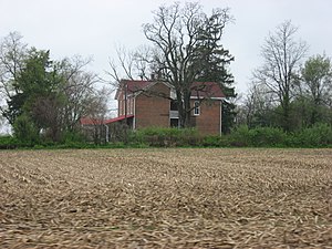
Charles Barr House
Historic house in Indiana, United States
Distance: Approx. 3323 meters
Latitude and longitude: 39.78888889,-85.77055556
Charles Barr House is a historic home located at Greenfield, Hancock County, Indiana. It was built in 1893, and is a 2+1⁄2-story, Queen Anne style frame dwelling with a two-story rear wing. It sits on a brick foundation and has a steep gable roof.
Rufus and Amanda Black House
Historic house in Indiana, United States
Distance: Approx. 2951 meters
Latitude and longitude: 39.77916667,-85.84138889
Rufus and Amanda Black House is a historic home located in Sugar Creek Township, Hancock County, Indiana. It was built about 1870, and is a two-story, L-shaped, Italianate style brick dwelling. It features an original two-story porch.
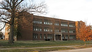
Lincoln Park School (Greenfield, Indiana)
United States historic place
Distance: Approx. 2778 meters
Latitude and longitude: 39.78833333,-85.77694444
Lincoln Park School, also known as Lincoln Park Elementary School and Greenfield High School, is a historic school building located at Greenfield, Hancock County, Indiana. It was built in 1926, and is a three-story, Classical Revival style brick building. The front facade features a projecting entrance portico.

Lilly Biological Laboratories
United States historic place
Distance: Approx. 1372 meters
Latitude and longitude: 39.78083333,-85.7975
Lilly Biological Laboratories, also known as Eli Lilly and Company and Greenfield Laboratories, is a historic laboratory complex located in Greenfield, Indiana. The laboratory was designed by Robert Frost Daggett and built in 1913-1914 for Eli Lilly and Company. The complex consists of three buildings: the Tower Building flanked by two adjacent two-story buildings connected to the main building by pergolas.
Greenfield Courthouse Square Historic District
Historic district in Indiana, United States
Distance: Approx. 1372 meters
Latitude and longitude: 39.78083333,-85.7975
Greenfield Courthouse Square Historic District is a national historic district located at Greenfield, Hancock County, Indiana, United States. The district encompasses 72 contributing buildings and 1 contributing object in the central business district of Greenfield that developed between about 1835 and 1935. The focal point of the district is the Romanesque Revival style Hancock County Courthouse (1896–1897) and Second Empire style jail.

Greenfield Residential Historic District
Historic district in Indiana, United States
Distance: Approx. 3138 meters
Latitude and longitude: 39.78527778,-85.77305556
Greenfield Residential Historic District is a national historic district located at Greenfield, Hancock County, Indiana. The district encompasses 523 contributing buildings, 1 contributing site, and 15 contributing structures in a predominantly residential section of Greenfield. It developed between about 1880 and 1947, and includes notable examples of Greek Revival, Gothic Revival, Italianate, Queen Anne, Colonial Revival, Neoclassical, Mission Revival, and Bungalow / American Craftsman style architecture.
Weather in this IP's area
clear sky
5 Celsius
3 Celsius
3 Celsius
7 Celsius
1023 hPa
88 %
1023 hPa
991 hPa
10000 meters
2.03 m/s
2.48 m/s
33 degree
1 %
07:18:22
20:03:28