Country:
Region:
City:
Latitude and Longitude:
Time Zone:
Postal Code:
IP information under different IP Channel
ip-api
Country
Region
City
ASN
Time Zone
ISP
Blacklist
Proxy
Latitude
Longitude
Postal
Route
Luminati
Country
Region
ne
City
mccook
ASN
Time Zone
America/Chicago
ISP
GREAT-PLAINS-COMMUNICATIONS
Latitude
Longitude
Postal
IPinfo
Country
Region
City
ASN
Time Zone
ISP
Blacklist
Proxy
Latitude
Longitude
Postal
Route
db-ip
Country
Region
City
ASN
Time Zone
ISP
Blacklist
Proxy
Latitude
Longitude
Postal
Route
ipdata
Country
Region
City
ASN
Time Zone
ISP
Blacklist
Proxy
Latitude
Longitude
Postal
Route
Popular places and events near this IP address
McCook, Nebraska
City in and county seat of Red Willow County, Nebraska, United States
Distance: Approx. 138 meters
Latitude and longitude: 40.20527778,-100.62611111
McCook is a city in and the county seat of Red Willow County, Nebraska, United States. The population was 7,446 at the 2020 census.
McCook Ben Nelson Regional Airport
Airport
Distance: Approx. 2823 meters
Latitude and longitude: 40.20638889,-100.59222222
McCook Ben Nelson Regional Airport (IATA: MCK, ICAO: KMCK, FAA LID: MCK) is two miles east of McCook, in Red Willow County, Nebraska. It was formerly McCook Municipal Airport and McCook Regional Airport. It sees one airline, subsidized by the Essential Air Service program.

McCook station
Railway station in McCook, Nebraska, US
Distance: Approx. 746 meters
Latitude and longitude: 40.1975,-100.6256
McCook station is an Amtrak intercity train station in McCook, Nebraska, served by the California Zephyr. The depot opened on April 13, 1926, by the Chicago, Burlington and Quincy Railroad to replace an earlier structure from 1882. The brown brick depot features Tudor Revival detailing as seen in the pointed arch windows and the buttresses that divide the facades into regular bays.
KBRL
Radio station in McCook, Nebraska
Distance: Approx. 2624 meters
Latitude and longitude: 40.19194444,-100.65166667
KBRL (1300 AM) is a radio station broadcasting a news/talk format. Licensed to McCook, Nebraska, United States, the station is currently owned by Armada Media.
George W. Norris House
Historic house in Nebraska, United States
Distance: Approx. 22 meters
Latitude and longitude: 40.20416667,-100.62555556
The Senator George William Norris House is a historic house museum at 706 Norris Avenue in McCook, Nebraska. It was purchased in 1899 by George W. Norris (1862–1944), a Nebraska politician who championed the New Deal of the 1930s and the Rural Electrification Act. It was donated to the Nebraska State Historical Society in 1968 by his wife, and was designated a National Historic Landmark in 1967.
Harvey P. Sutton House
Historic house in Nebraska, United States
Distance: Approx. 154 meters
Latitude and longitude: 40.20296111,-100.62611111
The Harvey P. Sutton House, also known as the H.P. Sutton House, is a six-bedroom, 4,000-square-foot (370 m2) Frank Lloyd Wright designed Prairie School home at 602 Norris Avenue in McCook, Nebraska. Although the house is known by her husband's name, Eliza Sutton was the driving force behind the commissioning of Wright for the design in 1905–1907 and the construction of the house in 1907–1908.
McCook Gazette
Newspaper published in McCook, US
Distance: Approx. 239 meters
Latitude and longitude: 40.202457,-100.626935
The McCook Daily Gazette is a newspaper published in the city of McCook, in the southwestern part of the state of Nebraska, in the Great Plains region of the United States. It serves southwestern Nebraska and northwestern Kansas. The newspaper is issued five days a week, Monday through Friday afternoons.
KQHK
Radio station in McCook, Nebraska
Distance: Approx. 6199 meters
Latitude and longitude: 40.17194444,-100.68472222
KQHK (103.9 FM, "103.9 The Hawk") is a radio station broadcasting a classic rock music format. Licensed to McCook, Nebraska, United States, the station is currently owned by Armada Media.
Keystone Hotel (McCook, Nebraska)
United States historic place
Distance: Approx. 593 meters
Latitude and longitude: 40.20583333,-100.63194444
The Keystone Hotel is a historic hotel building in McCook, Nebraska. It was built as a hotel in 1922, and it was remodelled as a retirement facility in 1970. It was designed in the Renaissance Revival style by Archer and Gloyd, an architectural firm based in Kansas City, Missouri.
McCook Public-Carnegie Library
United States historic place
Distance: Approx. 313 meters
Latitude and longitude: 40.20138889,-100.62527778
The McCook Public-Carnegie Library, also known as the McCook Carnegie Library, is a historic building in McCook, Nebraska, United States. It was built as a Carnegie library in 1905, and designed in the Spanish Colonial Revival style by Denver architect Willis Marean. It housed the McCook public library until 1969.
Red Willow County Courthouse
United States historic place
Distance: Approx. 252 meters
Latitude and longitude: 40.20194444,-100.62555556
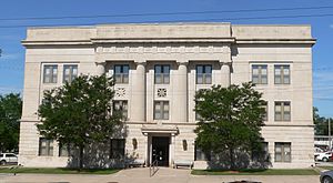
The Red Willow County Courthouse is a historic building in McCook, Nebraska, which serves as the courthouse of Red Willow County, Nebraska. Two prior county courthouses were built in Indianola, Nebraska, in 1873 and 1880, followed by a third one in McCook, built in 1896. The current courthouse was built in 1926.
McCook YMCA
United States historic place
Distance: Approx. 286 meters
Latitude and longitude: 40.20166667,-100.62583333
The McCook YMCA is a historic building in McCook, Nebraska. It was built in 1925 by Swanson & Sudik for the YMCA, and designed in the Mission Revival style by architect William N. Bowman. It housed McCook Junior College from 1926 to 1936.
Weather in this IP's area
clear sky
4 Celsius
3 Celsius
4 Celsius
7 Celsius
1017 hPa
70 %
1017 hPa
925 hPa
10000 meters
1.54 m/s
230 degree
07:27:43
17:26:33


