72.5.68.207 - IP Lookup: Free IP Address Lookup, Postal Code Lookup, IP Location Lookup, IP ASN, Public IP
Country:
Region:
City:
Location:
Time Zone:
Postal Code:
ISP:
ASN:
language:
User-Agent:
Proxy IP:
Blacklist:
IP information under different IP Channel
ip-api
Country
Region
City
ASN
Time Zone
ISP
Blacklist
Proxy
Latitude
Longitude
Postal
Route
db-ip
Country
Region
City
ASN
Time Zone
ISP
Blacklist
Proxy
Latitude
Longitude
Postal
Route
IPinfo
Country
Region
City
ASN
Time Zone
ISP
Blacklist
Proxy
Latitude
Longitude
Postal
Route
IP2Location
72.5.68.207Country
Region
california
City
cupertino
Time Zone
America/Los_Angeles
ISP
Language
User-Agent
Latitude
Longitude
Postal
ipdata
Country
Region
City
ASN
Time Zone
ISP
Blacklist
Proxy
Latitude
Longitude
Postal
Route
Popular places and events near this IP address

Cupertino, California
City in California, United States
Distance: Approx. 1475 meters
Latitude and longitude: 37.32305556,-122.03194444
Cupertino ( KOOP-ər-TEEN-oh) is a city in Santa Clara County, California, United States, directly west of San Jose on the western edge of the Santa Clara Valley with portions extending into the foothills of the Santa Cruz Mountains. The population was 60,381 as of the 2020 census. The city is widely known for being the home of Apple Inc., headquartered within the city at Apple Park.

De Anza College
Community college in Cupertino, California, U.S.
Distance: Approx. 306 meters
Latitude and longitude: 37.31916667,-122.04527778
De Anza College is a public community college in Cupertino, California, United States. It is part of the Foothill-De Anza Community College District, which also administers Foothill College in nearby Los Altos Hills, California. The college is named after the Spanish explorer Juan Bautista de Anza.

Monta Vista High School
Public secondary school in Cupertino, California, United States
Distance: Approx. 933 meters
Latitude and longitude: 37.3145,-122.0567
Monta Vista High School is a four-year public high school in Cupertino, California. Part of the Fremont Union High School District, the school serves most of the area of western Cupertino. In 2020, Monta Vista was ranked by Newsweek as the 69th best high school for STEM subjects in the United States.
Monta Vista, Cupertino, California
Neighborhood in California
Distance: Approx. 1226 meters
Latitude and longitude: 37.32272,-122.058017
Monta Vista is an upper-income residential neighborhood in western Cupertino, California, the 11th wealthiest city with a population over 50,000 in the United States. "Monta Vista" means "mountain view" however, it is not affiliated with the nearby city of Mountain View. Monta Vista in Cupertino is loosely referred to as the neighborhood that feeds into the high school Orchards and vineyards used to cover Monta Vista.
Saint Joseph of Cupertino Parish
Church in California, USA
Distance: Approx. 1538 meters
Latitude and longitude: 37.324204,-122.032001
Saint Joseph of Cupertino Parish is a territorial parish serving Latin Rite Catholics in Cupertino, California, United States. The parish is named for Joseph of Cupertino, and had its origin in a small wooden chapel at the Villa Maria retreat located in Stevens Creek Canyon (Stevens Creek was known in Spanish as Arroyo San José de Cupertino). Villa Maria was the country home of the Jesuit fathers of Santa Clara University, who purchased the 320-acre (130 ha) tract in 1873.

Apple Advanced Technology Group
Corporate research laboratory at Apple Computer (1986–1997)
Distance: Approx. 1514 meters
Latitude and longitude: 37.3216,-122.0306
The Advanced Technology Group (ATG) was a corporate research laboratory at Apple Computer from 1986 to 1997. ATG was an evolution of Apple's Education Research Group (ERG) and was started by Larry Tesler in October 1986 to study long-term research into future technologies that were beyond the time frame or organizational scope of any individual product group. Over the next decade, it was led by David Nagel, Richard LeFaivre, and Donald Norman.

Le Petit Trianon
Historic house in California, United States
Distance: Approx. 558 meters
Latitude and longitude: 37.3216089,-122.0466273
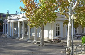
Le Petit Trianon is a historic mansion on the grounds of De Anza College at 21250 Stevens Creek Blvd. in Cupertino, California. The building now serves as the California History Center.

McClellan Ranch Preserve
Distance: Approx. 1472 meters
Latitude and longitude: 37.3144,-122.06289
McClellan Ranch Preserve is a public preserve located in the Monta Vista neighborhood of Cupertino that still retains its rural ranch look. It used to be a horse ranch owed by the McClellan family in the 1930s, and still preserves the original ranch house, a working milk barn and livestock barn, and a replica blacksmiths shop, along with a natural reserve in the middle of the park. A famous birding hot spot, the ranch park also houses the headquarters of the Santa Clara Valley Audubon Society and a nature museum and environmental education center.
Measurex
Distance: Approx. 489 meters
Latitude and longitude: 37.317,-122.052
Measurex was an American company based in Cupertino, California. It was one of the first companies to develop computer control systems for industry, primarily the paper-making industry. The development of the control systems included the development of control software, and development of scanning sensors to measure different properties of paper.

Don Burnett Bicycle-Pedestrian Bridge
Bridge in Cupertino, California, US
Distance: Approx. 1903 meters
Latitude and longitude: 37.33338889,-122.05055556
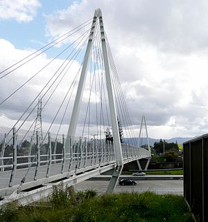
The Don Burnett Bicycle-Pedestrian Bridge, renamed from Mary Avenue Bridge on July 19, 2011, is a cable-stayed bridge over Interstate 280 (California), spanning Cupertino, California and Sunnyvale, California, used for bicycle and pedestrian traffic. It is the only cable-stayed pedestrian bridge over a highway in California. At night, the bridge is lit up and can be seen by those driving on Interstate 280.
Saint Joseph of Cupertino School
School in Cupertino, California, United States
Distance: Approx. 1681 meters
Latitude and longitude: 37.32444444,-122.03027778
Saint Joseph of Cupertino School is a parochial school located in Cupertino, California. It serves grades pre-k to 8. It is part of the Roman Catholic Diocese of San Jose in California.
Kennedy Middle School (Cupertino, California)
Public middle school in Cupertino, Santa Clara, California, United States
Distance: Approx. 779 meters
Latitude and longitude: 37.3109,-122.0516
John F. Kennedy Middle School is a public middle school in Cupertino, California, United States, feeding nearby Monta Vista High School. It is part of the Cupertino Union School District, which serves approximately 13,500 students, covering 20 nationalities and 45 languages. It was ranked by US News as the #13 best California Middle School and second best school in the Cupertino Union School District.
Weather in this IP's area
clear sky
12 Celsius
10 Celsius
10 Celsius
14 Celsius
1022 hPa
40 %
1022 hPa
995 hPa
10000 meters
1.54 m/s
350 degree

