Country:
Region:
City:
Latitude and Longitude:
Time Zone:
Postal Code:
IP information under different IP Channel
ip-api
Country
Region
City
ASN
Time Zone
ISP
Blacklist
Proxy
Latitude
Longitude
Postal
Route
Luminati
Country
Region
va
City
arlington
ASN
Time Zone
America/New_York
ISP
INTERNAP-BLK
Latitude
Longitude
Postal
IPinfo
Country
Region
City
ASN
Time Zone
ISP
Blacklist
Proxy
Latitude
Longitude
Postal
Route
db-ip
Country
Region
City
ASN
Time Zone
ISP
Blacklist
Proxy
Latitude
Longitude
Postal
Route
ipdata
Country
Region
City
ASN
Time Zone
ISP
Blacklist
Proxy
Latitude
Longitude
Postal
Route
Popular places and events near this IP address

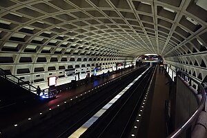
Farragut West station
Washington Metro station
Distance: Approx. 134 meters
Latitude and longitude: 38.90138889,-77.03944444
Farragut West station is a Washington Metro station in Downtown Washington, D.C., United States. The side-platformed station was opened on July 1, 1977, and is operated by the Washington Metropolitan Area Transit Authority (WMATA). Providing service for the Blue, Orange and Silver Lines, the station is located just west of Farragut Square with two entrances on I Street at 17th and 18th Streets NW. While it is only a block away (across the square) from Farragut North station on the Red Line, there is no direct connection between the two stations.

Farragut Square
Urban park in Washington, D.C., U.S.
Distance: Approx. 68 meters
Latitude and longitude: 38.90193056,-77.03895833
Farragut Square is a city square in Washington, D.C.'s Ward 2. It is bordered by K Street NW to the north, I Street NW to the south, on the east and west by segments of 17th Street NW, and interrupts Connecticut Avenue NW. It is the sister park of McPherson Square two blocks east. It is serviced by two stops on the Washington Metro rail system: Farragut North on the Red Line and Farragut West on the Blue, Orange, and Silver Lines.

The Hill (newspaper)
American political newspaper and website
Distance: Approx. 122 meters
Latitude and longitude: 38.90305556,-77.0375
The Hill, formed in 1994, is an American newspaper and digital media company based in Washington, D.C.. Focusing on politics, policy, business and international relations, The Hill's coverage includes the U.S. Congress, the presidency and executive branch, and election campaigns. Its stated output is "nonpartisan reporting on the inner workings of Government and the nexus of politics and business".

Representative Office of Northern Cyprus to the United States
Distance: Approx. 100 meters
Latitude and longitude: 38.903,-77.03811111
The Representative Office of Northern Cyprus is a representative office of the Turkish Republic of Northern Cyprus to the United States. The United States does not formally recognize the Turkish Republic of Northern Cyprus, and therefore the office is legally a commercial enterprise. The staff of the Representative Offices do not have diplomatic visas and only operate within the United States using business visas.
National Fish and Wildlife Foundation
American foundation
Distance: Approx. 81 meters
Latitude and longitude: 38.90155556,-77.03758333
The National Fish and Wildlife Foundation (NFWF) is an American foundation that was chartered by the United States Congress in 1984 to increase the resources available for the conservation of the nation's fish, wildlife, plants, and habitats.
1625 Eye Street
Office/Parking Garage in D.C., United States
Distance: Approx. 81 meters
Latitude and longitude: 38.90155556,-77.03758333
1625 Eye Street is a high-rise building located in Washington, D.C., United States. Its construction began in 2001 and was completed in 2003. The building rises to 160 feet (49 m), featuring 12 floors and 10 elevators to serve those 12 floors.
Third Church of Christ, Scientist (Washington, D.C.)
Building in D.C., United States
Distance: Approx. 105 meters
Latitude and longitude: 38.902,-77.037
Third Church of Christ, Scientist, established in 1918, is a Christian Science church in downtown Washington, D.C. From 1971 to 2014, the church was located in a controversial building at 16th and I Street NW. Considered a significant work of "Brutalist" church architecture by some critics, the building was considered unsatisfactory by members of the Church's congregation, which shrank over the years. In 2007, the church applied for a demolition permit for the building to permit sale and redevelopment of the site, with plans to relocate to a more suitable structure. A 1991 application for landmark status for the building, filed to forestall a demolition threat then, was subsequently approved.
Center for Strategic and Budgetary Assessments
Distance: Approx. 103 meters
Latitude and longitude: 38.9030225,-77.03813389
The Center for Strategic and Budgetary Assessments (CSBA) is an independent, non-profit, Washington, D.C.–based think tank specializing in US defense policy, force planning, and budgets. It is headed by Thomas Mahnken. CSBA's stated mission is "to develop innovative, resource-informed defense concepts, promote public debate, and spur action to advance U.S. and allied interests." CSBA emphasizes initiatives the United States and its allies can take to wisely invest in the future, including during periods of fiscal austerity and uncertainty.

Little Green House on K Street
Distance: Approx. 111 meters
Latitude and longitude: 38.90283333,-77.03733333
The Little Green House on K Street was a residence at 1625 K Street, NW, Washington DC, USA, where the notoriously corrupt deals of Warren Harding's presidency (1921–1923) are believed to have been planned.
Statue of David Farragut (Washington, D.C.)
Artwork by Vinnie Ream
Distance: Approx. 68 meters
Latitude and longitude: 38.90193056,-77.03895833
Admiral David G. Farragut is a statue in Washington, D.C., honoring David Farragut, a career military officer who served as the first admiral in the United States Navy. The monument is sited in the center of Farragut Square, a city square in downtown Washington, D.C. The statue was sculpted by female artist Vinnie Ream, whose best-known works include a statue of Abraham Lincoln and several statues in the National Statuary Hall Collection. The monument was dedicated in 1881 in an extravagant ceremony attended by President James A. Garfield, members of his cabinet, and thousands of spectators.

Washington Bookshop
Distance: Approx. 121 meters
Latitude and longitude: 38.9021,-77.0396
Washington Bookshop, also known as the Washington Cooperative Bookshop, was a World War II-era bookstore in Washington, DC, at 916 17th St NW. It was established in 1938 as a cooperative. Its 1200 members were able to purchase books from this bookshop at a special discounted rate; there were also an art gallery and a lecture space where evening events were held. Lectures held at the store included a 12-week series of lectures on anthropology by Paul Radin; Eleanor Roosevelt also spoke to the bookshop's members.

Army and Navy Club (Washington, D.C.)
Organization in United States
Distance: Approx. 67 meters
Latitude and longitude: 38.9015,-77.0382
The Army and Navy Club is a private club located at 901 17th Street NW, Washington, D.C. The Army and Navy Club Building is one of the tallest buildings in the city of Washington.
Weather in this IP's area
clear sky
15 Celsius
14 Celsius
14 Celsius
16 Celsius
1016 hPa
52 %
1016 hPa
1014 hPa
10000 meters
6.17 m/s
310 degree
06:52:37
16:53:42

