72.27.226.168 - IP Lookup: Free IP Address Lookup, Postal Code Lookup, IP Location Lookup, IP ASN, Public IP
Country:
Region:
City:
Location:
Time Zone:
Postal Code:
IP information under different IP Channel
ip-api
Country
Region
City
ASN
Time Zone
ISP
Blacklist
Proxy
Latitude
Longitude
Postal
Route
Luminati
Country
Region
nc
City
asheville
ASN
Time Zone
America/New_York
ISP
AS-ERCBB
Latitude
Longitude
Postal
IPinfo
Country
Region
City
ASN
Time Zone
ISP
Blacklist
Proxy
Latitude
Longitude
Postal
Route
IP2Location
72.27.226.168Country
Region
north carolina
City
asheville
Time Zone
America/New_York
ISP
Language
User-Agent
Latitude
Longitude
Postal
db-ip
Country
Region
City
ASN
Time Zone
ISP
Blacklist
Proxy
Latitude
Longitude
Postal
Route
ipdata
Country
Region
City
ASN
Time Zone
ISP
Blacklist
Proxy
Latitude
Longitude
Postal
Route
Popular places and events near this IP address
Harrah's Cherokee Center
Multipurpose entertainment center in Asheville, North Carolina, U.S.
Distance: Approx. 142 meters
Latitude and longitude: 35.597547,-82.555384
The Harrah's Cherokee Center – Asheville, previously known as the U.S. Cellular Center and originally as the Asheville Civic Center Complex, is a multipurpose entertainment center, located in Asheville, North Carolina. Opened in 1974, the complex is home to an arena, auditorium, banquet hall and meeting rooms.
Asheville Citizen-Times
Newspaper published in Asheville, North Carolina, United States
Distance: Approx. 178 meters
Latitude and longitude: 35.595496,-82.5574
The Asheville Citizen-Times is a daily newspaper of Asheville, North Carolina. It was formed in 1991 as a result of a merger of the morning Asheville Citizen and the afternoon Asheville Times. It is owned by Gannett.

Basilica of St. Lawrence, Asheville
Catholic minor basilica in Asheville, North Carolina
Distance: Approx. 110 meters
Latitude and longitude: 35.5972,-82.5562
The Minor Basilica of St. Lawrence the Deacon & Martyr is a minor basilica of the Catholic Church in downtown Asheville, North Carolina, United States. The church was designed and built in 1905 by Spanish architect Rafael Guastavino along with his fellow architect R. S. Smith and the Catholic community of Asheville.
WRES-LP
Radio station in Asheville, North Carolina
Distance: Approx. 100 meters
Latitude and longitude: 35.597,-82.555
WRES-LP (100.7 FM) is a non-commercial low-power FM (LPFM) radio station located in Asheville, North Carolina, that features a mixture of Urban Contemporary, Jazz, Gospel, and news and information targeted to the area's African-American population.
Tupelo Honey Cafe
Distance: Approx. 196 meters
Latitude and longitude: 35.5947,-82.5548
Tupelo Honey Cafe is a restaurant chain based in downtown Asheville, North Carolina, specializing in Southern cooking. The restaurant was established in 2000 by Sharon Schott. The company has since expanded to 26 locations across 17 states.
The Warren Haynes Christmas Jam
Distance: Approx. 113 meters
Latitude and longitude: 35.5973,-82.5555
The Warren Haynes Christmas Jam is a one-of-a-kind music marathon curated and presented by Grammy Award-winning vocalist-songwriter and guitarist Warren Haynes. Since its inception in 1988, the concert has provided an opportunity for the performing artists, audience and the local community to give back during the holiday season. Over the past 18 years, Haynes - an Asheville native - has worked closely with the Asheville Area Habitat for Humanity.

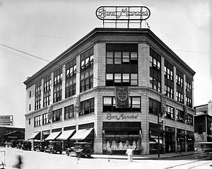
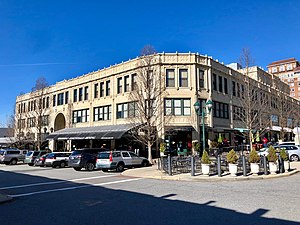
The Bon Marché Building of Asheville, North Carolina
Distance: Approx. 129 meters
Latitude and longitude: 35.5954,-82.5548
The Bon Marché Building of Asheville, North Carolina, now the Haywood Park Hotel, was built in 1923 by E.W. Grove for the store's owner, Solomon Lipinsky. This was several years before Grove began construction on nearby Grove Arcade, one of Asheville's most famous architectural landmarks. The Bon Marché building was designed by W.L. Stoddart, a hotel architect who also designed the Battery Park Hotel and Vanderbilt Hotel.

Grove Arcade
United States historic place
Distance: Approx. 121 meters
Latitude and longitude: 35.59555556,-82.55666667
The Grove Arcade, also known as the Arcade Building, is a historic commercial and residential building in Asheville, North Carolina, in its downtown historic district. It was built from 1926 to 1929, and is a Tudor Revival and Late Gothic Revival style building consisting of two stacked blocks. The lower block is a rectangular slab with rounded corners; it is capped by the second block, a two-tier set-back story.
Downtown Asheville Historic District
Historic district in North Carolina, United States
Distance: Approx. 259 meters
Latitude and longitude: 35.595,-82.55333333
Downtown Asheville Historic District is a national historic district located at Asheville, Buncombe County, North Carolina. The district encompasses about 279 contributing buildings and one contributing object in the central business district of Asheville. It includes commercial, institutional, and residential buildings in a variety of popular architectural styles including Colonial Revival, Queen Anne, and Art Deco.

Flatiron Building (Asheville, North Carolina)
United States historic place
Distance: Approx. 152 meters
Latitude and longitude: 35.595,-82.5552
The Flatiron Building on Battery Park Avenue in Asheville, North Carolina was completed in 1926. The nine-story 52,000-square-foot building was designed by New York architect Albert C. Wirth and built by L. B. Jackson Builders of Asheville. It is a contributing building to the Downtown Asheville Historic District.

Chai Pani
Restaurant in Asheville, North Carolina, U.S.
Distance: Approx. 147 meters
Latitude and longitude: 35.595,-82.5554
Chai Pani is an Indian street food restaurant based in Asheville, North Carolina, and the 2022 winner of the James Beard Foundation Award for "Outstanding Restaurant". It was founded in 2009 by chef Meherwan Irani and his wife Molly. They opened a second location in Decatur, Georgia in March 2013, which first copied the original's menu but now focuses on the cuisine of India's Deccan Plateau, where Meherwan spent his childhood.
The Market Place (restaurant)
Restaurant in Asheville, North Carolina, U.S.
Distance: Approx. 189 meters
Latitude and longitude: 35.594635,-82.555275
The Market Place is a restaurant in Asheville, North Carolina. It was a semifinalist in the Outstanding Restaurant category of the James Beard Foundation Awards in 2024. It is owned by chef William Dissen.
Weather in this IP's area
scattered clouds
5 Celsius
3 Celsius
3 Celsius
6 Celsius
1028 hPa
78 %
1028 hPa
947 hPa
10000 meters
1.7 m/s
2.16 m/s
132 degree
48 %