Country:
 USA
USARegion:
City:
Latitude and Longitude:
Time Zone:
Postal Code:
IP information under different IP Channel
ip-api
Country
Region
City
ASN
Time Zone
ISP
Blacklist
Proxy
Latitude
Longitude
Postal
Route
IPinfo
Country
Region
City
ASN
Time Zone
ISP
Blacklist
Proxy
Latitude
Longitude
Postal
Route
MaxMind
Country
Region
City
ASN
Time Zone
ISP
Blacklist
Proxy
Latitude
Longitude
Postal
Route
Luminati
Country
USRegion
mo
City
kansascity
ASN
Time Zone
America/Chicago
ISP
LINKCITY
Latitude
Longitude
Postal
db-ip
Country
Region
City
ASN
Time Zone
ISP
Blacklist
Proxy
Latitude
Longitude
Postal
Route
ipdata
Country
Region
City
ASN
Time Zone
ISP
Blacklist
Proxy
Latitude
Longitude
Postal
Route
Popular places and events near this IP address

Avondale, Missouri
City in Missouri, United States
Distance: Approx. 2123 meters
Latitude and longitude: 39.15444444,-94.54527778
Avondale is a city in Clay County, Missouri, United States. The population was 436 at the 2020 census. It is part of the Kansas City metropolitan area.

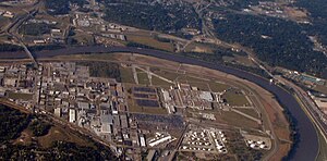
North Kansas City, Missouri
City in Missouri, United States
Distance: Approx. 1039 meters
Latitude and longitude: 39.13972222,-94.56416667
North Kansas City is a city in Clay County, Missouri, United States. It is also enclaved in Kansas City. Even though the name is similar to its larger counterpart, Kansas City, it is an independent municipality and part of the Kansas City metropolitan area.
Fairfax Assembly & Stamping
Automobile assembly plant in the US
Distance: Approx. 3001 meters
Latitude and longitude: 39.14722222,-94.60333333
Fairfax Assembly & Stamping is a General Motors automobile factory at 3201 Fairfax Trafficway, Kansas City, Kansas in the United States. As of 2022, the 4,900,000 sq ft (460,000 m2) plant employs over 2,100 hourly and salaried employees. Employees are represented by United Auto Workers Local 31.
Saint Pius X Catholic High School (Kansas City, Missouri)
School in Kansas City, Missouri, United States
Distance: Approx. 2779 meters
Latitude and longitude: 39.17277778,-94.56166667
St. Pius X Catholic High School is a private Catholic university preparatory secondary school in Kansas City, Missouri (U.S.). It is located in the Diocese of Kansas City–Saint Joseph.

North Kansas City High School
Public school in North Kansas City, Missouri
Distance: Approx. 494 meters
Latitude and longitude: 39.1457,-94.57314
North Kansas City High School (also known as NKCHS, NKC, and Northtown) is a high school in North Kansas City, Missouri, United States, with over 1,900 students enrolled. It is a part of the North Kansas City School District. The first graduating class found of record was in 1917 with three known graduates.

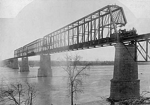
Paseo Bridge
Bridge in Kansas City, Missouri
Distance: Approx. 2862 meters
Latitude and longitude: 39.12277778,-94.56583333
The Paseo Bridge was a suspension bridge over the Missouri River in Kansas City, Missouri. Before being replaced by the Christopher S. Bond Bridge, it carried Interstates 29 and 35 and U.S. Route 71 over the river. It was named for The Paseo, a boulevard that connected with the bridge to the south, and continues to do so with the Bond Bridge.
Chouteau Bridge
Bridge in Kansas City, Missouri
Distance: Approx. 3013 meters
Latitude and longitude: 39.14555556,-94.53388889
The Chouteau Bridge a four-lane girder bridge on Route 269 across the Missouri River between Jackson County, Missouri, and Clay County, Missouri. The bridge is named for François Chouteau, who was a member of the Chouteau fur trapping family and is considered the first permanent settler in what became Kansas City. Two successive bridges have carried the name Chouteau Bridge.

Harrah's North Kansas City
Distance: Approx. 2869 meters
Latitude and longitude: 39.148548,-94.535371
Harrah's North Kansas City is a hotel and casino in North Kansas City, Missouri. Located just north of Kansas City on the Missouri River, it has more than 1,800 slot machines, table games, and video games, and six restaurants.

Sears, Roebuck and Company Warehouse Building (North Kansas City, Missouri)
United States historic place
Distance: Approx. 729 meters
Latitude and longitude: 39.14222222,-94.57138889
Sears, Roebuck and Company Warehouse Building, also known as Missouri Poster and Sign Company, Inc. and Bellas Hess Antique Mall, is a historic warehouse building located at North Kansas City, Missouri. It was built in 1912–1923, and is a nine-story building built as a merchandise warehouse for Sears.

Wheeling Corrugating Company Building
United States historic place
Distance: Approx. 1563 meters
Latitude and longitude: 39.13444444,-94.57055556
Wheeling Corrugating Company Building, also known as Cook Composites and Polymers (CCP), is a historic factory building located at North Kansas City, Missouri. It was built in 1920, and is a five-story, six-bay, rectangular reinforced concrete building faced in brick with cut stone trim. A one-story, concrete block addition was built about 1950.: 5 It produced corrugated galvanised iron for roofing.

Armour Theatre Building
United States historic place
Distance: Approx. 745 meters
Latitude and longitude: 39.14444444,-94.57555556
Armour Theatre Building is a historic theatre building located at North Kansas City, Missouri. It was designed by the architectural firm Keene & Simpson and built in 1928. It is a two-story, polychromatic brick building with Spanish Eclectic style design elements.

CPKC Stadium
Soccer-specific stadium in Kansas City, Missouri
Distance: Approx. 3131 meters
Latitude and longitude: 39.12033333,-94.56625
CPKC Stadium is a soccer-specific stadium located in Kansas City, Missouri, that serves as the home ground for the Kansas City Current of the National Women's Soccer League. The stadium opened for the Current's first home match of the 2024 season on March 16, 2024. Canadian Pacific Kansas City, abbreviated to CPKC in the stadium name, has the current naming rights.
Weather in this IP's area
clear sky
19 Celsius
19 Celsius
17 Celsius
21 Celsius
1017 hPa
78 %
1017 hPa
990 hPa
10000 meters
2.24 m/s
80 degree
07:18:25
18:54:22