Country:
Region:
City:
Latitude and Longitude:
Time Zone:
Postal Code:
IP information under different IP Channel
ip-api
Country
Region
City
ASN
Time Zone
ISP
Blacklist
Proxy
Latitude
Longitude
Postal
Route
Luminati
Country
Region
tx
City
houston
ASN
Time Zone
America/Chicago
ISP
PSLIGHTWAVE
Latitude
Longitude
Postal
IPinfo
Country
Region
City
ASN
Time Zone
ISP
Blacklist
Proxy
Latitude
Longitude
Postal
Route
db-ip
Country
Region
City
ASN
Time Zone
ISP
Blacklist
Proxy
Latitude
Longitude
Postal
Route
ipdata
Country
Region
City
ASN
Time Zone
ISP
Blacklist
Proxy
Latitude
Longitude
Postal
Route
Popular places and events near this IP address
Mission Bend, Texas
Census-designated place in Texas, United States
Distance: Approx. 4070 meters
Latitude and longitude: 29.69361111,-95.66166667
Mission Bend is a census-designated place (CDP) around Texas State Highway 6 within the extraterritorial jurisdiction of Houston in Fort Bend and Harris counties in the U.S. state of Texas; Mission Bend is 4 miles (6 km) northwest of the city hall of Sugar Land and 20 miles (32 km) southwest of Downtown Houston. The population was 36,914 at the 2020 census.
Alief, Houston
Place in Texas, United States
Distance: Approx. 3284 meters
Latitude and longitude: 29.71111111,-95.59638889
Alief ( AY-leef) is a working-class suburb in Southwest Harris County, Texas, United States. Most of Alief is within the city limits of Houston, while a portion of the community is in unincorporated Harris County. First settled in 1894 as a rural farm community, Alief experienced rapid population growth in the 1970s and 1980s.

Alief Elsik High School
Public school in Texas, United States
Distance: Approx. 2697 meters
Latitude and longitude: 29.71,-95.603
Alief Elsik High School is a high school in the Alief region of Houston, Texas, United States. Elsik is divided into two campuses: the main campus (12601 High Star in Houston, zip code 77072), and the Alief Elsik Ninth Grade Center (located at 6767 South Dairy Ashford, city of Houston, 77072), which serves ninth graders. Both campuses, which are in the Alief Independent School District, serve grades 9 through 12.

Alief Kerr High School
Magnet school in Texas, United States
Distance: Approx. 2951 meters
Latitude and longitude: 29.69111,-95.634313
Alief Kerr High School is an Alief ISD public school located in the Alief community, and in the limited purpose city limits of Houston, Texas, United States. The school is a part of the Alief Independent School District and serves grades 9 through 12. Kerr High School was awarded the Blue Ribbon School Award of Excellence by the United States Department of Education, the highest award an American school can receive, during the 2010–11 school year.

Alief Taylor High School
Public school in Texas, United States
Distance: Approx. 2504 meters
Latitude and longitude: 29.695,-95.633
Alief Taylor High School is a public high school in the Alief Independent School District. It is located in an unincorporated area in the Alief community of Harris County, near Houston, Texas, United States. Opened in 2001, Alief Taylor is the newest high school in the district.

The Village School (Houston)
Private, boarding school in Houston, Texas, United States
Distance: Approx. 3470 meters
Latitude and longitude: 29.746816,-95.61805
The Village School is a coeducational non-denominational college preparatory private school for grades Pre-K through high school in Houston, Texas.
Royal Oaks Country Club
Country club and subdivision in Texas, United States
Distance: Approx. 4475 meters
Latitude and longitude: 29.7271,-95.58471
Royal Oaks Country Club is a country club and subdivision in Houston, Texas, United States, in the Alief community. The country club is located at 2910 Royal Oaks Club Drive, 8 miles (13 km) west of The Galleria. Sunrise Colony Company developed Royal Oaks out of the former Andrau Airpark property.
West Oaks Mall (Houston)
Shopping mall in Texas, United States
Distance: Approx. 2451 meters
Latitude and longitude: 29.73217,-95.6483
West Oaks Mall is a regional shopping mall located in the Alief area of the west side of Houston, Texas, USA, that opened in 1984. With a trade area serving far western parts of Houston including a business clientele in the Energy Corridor and suburban neighborhoods west of George Bush Park in the Greater Katy and Fulshear areas, the mall is located at Texas State Highway 6 and Westheimer Road and can easily be accessed south on Highway 6 via Interstate 10. The anchors are Dillard's Clearance Center, Crazy Boss, The Outlet at West Oaks, and Fortis College.

The Briarwood School (Houston, Texas)
Private school in Houston, Texas
Distance: Approx. 4671 meters
Latitude and longitude: 29.7472,-95.5957
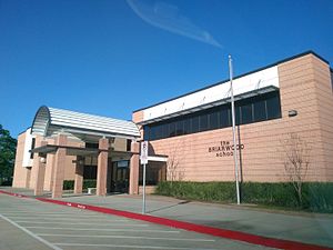
The Briarwood School is a private school in Houston, Texas, in the Briar Forest community.
Texas Buddhist Association
Buddhist organization based in the United States
Distance: Approx. 2814 meters
Latitude and longitude: 29.70156,-95.60683
The Texas Buddhist Association (TBA, traditional Chinese: 德州佛教會; simplified Chinese: 德州佛教会; pinyin: Dézhōu Fójiào Huì) is a non-profit nondenominational religious organization committed to providing religious ceremonies and educational programs and serving the community. Not distinguishing between different sects of Buddhism, TBA places an emphasis on spreading the right views of the Dharma. The mission statement is to adopt and practice Buddha's teachings of loving kindness, compassion, joyfulness, and serenity in our daily lives for the benefit of ourselves and others; and to cultivate the wisdom necessary for clear understanding of both the universe and the human spirit.
Howellville, Texas
Unincorporated area in Texas, United States
Distance: Approx. 808 meters
Latitude and longitude: 29.71138889,-95.63444444
Howellville or Howell is an unincorporated community in Harris County, Texas, United States, which has been absorbed by Greater Houston. The site is located at the intersection of Alief Clodine Road and Sugar Land Howell Road on the west side of Houston, approximately halfway between the original settlements of Clodine and Alief. There are no road signs identifying the place.

Lakes of Parkway, Houston
Community in Texas, United States
Distance: Approx. 3433 meters
Latitude and longitude: 29.748,-95.633
Lakes of Parkway is a gated community in western Houston, Texas, also the most southern community in the Energy Corridor. It has 888 lots. Peggy O'Hare of the Houston Chronicle stated in 2002 that the houses were "upscale".
Weather in this IP's area
clear sky
23 Celsius
22 Celsius
22 Celsius
24 Celsius
1016 hPa
35 %
1016 hPa
1014 hPa
10000 meters
4.63 m/s
340 degree
06:46:51
17:27:28

