72.19.61.18 - IP Lookup: Free IP Address Lookup, Postal Code Lookup, IP Location Lookup, IP ASN, Public IP
Country:
Region:
City:
Location:
Time Zone:
Postal Code:
IP information under different IP Channel
ip-api
Country
Region
City
ASN
Time Zone
ISP
Blacklist
Proxy
Latitude
Longitude
Postal
Route
Luminati
Country
Region
nv
City
mesquite
ASN
Time Zone
America/Los_Angeles
ISP
CASCADE-ACCESS-LLC-CA-ESTOR1
Latitude
Longitude
Postal
IPinfo
Country
Region
City
ASN
Time Zone
ISP
Blacklist
Proxy
Latitude
Longitude
Postal
Route
IP2Location
72.19.61.18Country
Region
nevada
City
mesquite
Time Zone
America/Los_Angeles
ISP
Language
User-Agent
Latitude
Longitude
Postal
db-ip
Country
Region
City
ASN
Time Zone
ISP
Blacklist
Proxy
Latitude
Longitude
Postal
Route
ipdata
Country
Region
City
ASN
Time Zone
ISP
Blacklist
Proxy
Latitude
Longitude
Postal
Route
Popular places and events near this IP address

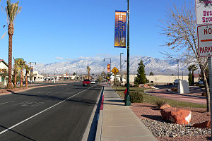
Mesquite, Nevada
City in Nevada, United States
Distance: Approx. 933 meters
Latitude and longitude: 36.8025,-114.08222222
Mesquite is a city in Clark County, Nevada, United States adjacent to the Arizona state line and 80 miles (130 km) northeast of Las Vegas on Interstate 15. As of the 2020 census, the city had a population of 20,471. The city is located in the Virgin River valley adjacent to the Virgin Mountains in the northeastern part of the Mojave Desert.
Mesquite Airport
Airport
Distance: Approx. 3219 meters
Latitude and longitude: 36.83305556,-114.05583333
Mesquite Airport (IATA: MFH, FAA LID: 67L) is a public use airport located two nautical miles (4 km) north of the central business district of Mesquite, in Clark County, Nevada, United States. It is owned by the City of Mesquite. The National Plan of Integrated Airport Systems for 2011–2015 categorized it as a general aviation facility.

Virgin Valley Heritage Museum
United States historic place
Distance: Approx. 1091 meters
Latitude and longitude: 36.80416667,-114.06805556
The Virgin Valley Heritage Museum, originally known as the Desert Valley Museum, is in Mesquite, Nevada and is listed on the United States National Register of Historic Places. The museum displays exhibits about area pioneers and local history.

Parley Hunt House
Historic house in Nevada, United States
Distance: Approx. 5160 meters
Latitude and longitude: 36.77555556,-114.11638889
Parley Hunt House is a historic home in Bunkerville, Nevada which was listed on the National Register of Historic Places in 1991. It is a one-story stone hall and parlor plan house built by Parley Hunt in 1907, for use by himself and his mother. It was originally a three-room L-shaped house, with a rear room used for cooking.
Mesquite High School Gymnasium
United States historic place
Distance: Approx. 1067 meters
Latitude and longitude: 36.805603,-114.067227
The Mesquite High School Gymnasium, at 144 E. North 1st St. in Mesquite, Nevada, was built in 1939. It was listed on the National Register of Historic Places in 1992.
Stateline Casino
Distance: Approx. 687 meters
Latitude and longitude: 36.804,-114.079
Stateline Hotel and Casino was located in West Wendover straddling the Nevada/Utah border.

Virgin Valley
Valley in Clark County, Nevada and Mohave County, Arizona
Distance: Approx. 933 meters
Latitude and longitude: 36.8025,-114.08222222
The Virgin Valley is a valley in northwest Arizona and southeast Nevada on the Virgin River. The Virgin River drains southwest Utah and southeast Nevada; parts of Arizona, especially the Arizona Strip region drain southwards into the Virgin River and Valley. The Virgin Valley begins as the Virgin River exits the Virgin River Gorge between the Beaver Dam Mountains and Wilderness north, and the northeast of the Virgin Mountains on the south of the Gorge.

CasaBlanca Resort
Hotel and casino in Nevada, United States
Distance: Approx. 2160 meters
Latitude and longitude: 36.802619,-114.100163
CasaBlanca is a hotel, casino, and RV park located in Mesquite, Nevada. The resort, originally known as Players Island, was opened by Players International on June 29, 1995. After struggling financially, the resort was sold to Randy Black Sr., who renamed it as the CasaBlanca in July 1997.
Virgin Valley High School
Public high school in Mesquite, Nevada, United States
Distance: Approx. 2392 meters
Latitude and longitude: 36.81397,-114.0514
Virgin Valley High School is a high school in Mesquite, Nevada under the jurisdiction of the Clark County School District. Up until the opening of Beaver Dam High School in Beaver Dam, Arizona in the fall of 2004, high school students from the Littlefield Unified School District across the Arizona state line attended high school at Virgin Valley.
Oasis (hotel and casino)
Former hotel and casino in Mesquite, Nevada
Distance: Approx. 1713 meters
Latitude and longitude: 36.8047,-114.0958
Oasis was a hotel and casino located on 26 acres (11 ha) of land at 897 West Mesquite Boulevard in Mesquite, Nevada, adjacent to Interstate 15. It began as the Western Village Truck Stop in the 1960s. William "Si" Redd purchased it in 1976 and renamed it five years later as Peppermill's Western Village.
Rising Star Sports Ranch
Resort in Nevada, United States
Distance: Approx. 1128 meters
Latitude and longitude: 36.810503,-114.065149
Rising Star Sports Ranch Resort is a hotel resort and sports facility in Mesquite, Nevada. It originally began construction in 1996, as the Mesquite Star hotel-casino. Construction was delayed because of financial issues, but it began to pick up heavily in October 1997.
Eureka (hotel and casino)
Casino hotel in Nevada, United States
Distance: Approx. 1532 meters
Latitude and longitude: 36.817637,-114.063413
Eureka Casino Resort is a hotel and casino in Mesquite, Nevada. It initially operated under the name Rancho Mesquite. The hotel portion, originally part of the Holiday Inn chain, opened in August 1996.
Weather in this IP's area
clear sky
5 Celsius
1 Celsius
5 Celsius
5 Celsius
1021 hPa
39 %
1021 hPa
926 hPa
10000 meters
4.62 m/s
7.02 m/s
4 degree

