72.19.37.222 - IP Lookup: Free IP Address Lookup, Postal Code Lookup, IP Location Lookup, IP ASN, Public IP
Country:
Region:
City:
Location:
Time Zone:
Postal Code:
IP information under different IP Channel
ip-api
Country
Region
City
ASN
Time Zone
ISP
Blacklist
Proxy
Latitude
Longitude
Postal
Route
Luminati
Country
Region
nv
City
mesquite
ASN
Time Zone
America/Los_Angeles
ISP
CASCADE-ACCESS-LLC-CA-ESTOR1
Latitude
Longitude
Postal
IPinfo
Country
Region
City
ASN
Time Zone
ISP
Blacklist
Proxy
Latitude
Longitude
Postal
Route
IP2Location
72.19.37.222Country
Region
florida
City
crestview
Time Zone
America/Chicago
ISP
Language
User-Agent
Latitude
Longitude
Postal
db-ip
Country
Region
City
ASN
Time Zone
ISP
Blacklist
Proxy
Latitude
Longitude
Postal
Route
ipdata
Country
Region
City
ASN
Time Zone
ISP
Blacklist
Proxy
Latitude
Longitude
Postal
Route
Popular places and events near this IP address

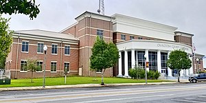
Okaloosa County, Florida
County in the United States
Distance: Approx. 8567 meters
Latitude and longitude: 30.6875,-86.5925
Okaloosa County is a county located in the northwestern portion of the U.S. state of Florida, extending from the Gulf of Mexico to the Alabama state line. As of the 2020 census, the population was 211,668. Its county seat is Crestview.

Crestview, Florida
City in Florida, United States
Distance: Approx. 910 meters
Latitude and longitude: 30.75416667,-86.57277778
Crestview is the largest city in Okaloosa County, Florida, United States. The population was 27,134 at the 2020 census, up from 20,978 at the 2010 census. It is the county seat of Okaloosa County.

Crestview Commercial Historic District
Historic district in Florida, United States
Distance: Approx. 328 meters
Latitude and longitude: 30.75916667,-86.57083333
The Crestview Commercial Historic District is a U.S. historic district in Crestview, Florida. It is roughly bounded by Industrial Drive, North Ferdon Boulevard, North Wilson Street, and James Lee Boulevard. On July 20, 2006, it was added to the U.S. National Register of Historic Places.

Crestview station (Florida)
Distance: Approx. 501 meters
Latitude and longitude: 30.757735,-86.56922
Crestview station is a former train station in Crestview, Florida. The station was built in 1993 when the Sunset Limited was extended east to Miami. Service to the station has been suspended since Hurricane Katrina struck the Gulf Coast in 2005.
Crestview High School (Florida)
School in Crestview, Okaloosa County, Florida, United States
Distance: Approx. 3216 meters
Latitude and longitude: 30.7896,-86.5602
Crestview High School (also known as CHS) is the only high school in the city of Crestview, Florida. It was founded in 1926, and was part of a racially segregated system, serving only white students until 1966, when the students from Carver-Hill, the school for African-Americans, were transferred there. It is the largest high school in the Okaloosa County School District, which serves all of Okaloosa County.
Bob Sikes Airport
Airport in Okaloosa County, Florida
Distance: Approx. 4989 meters
Latitude and longitude: 30.77883333,-86.52211111
Bob Sikes Airport (IATA: CEW, ICAO: KCEW, FAA LID: CEW), named for Robert L. F. Sikes, is a public-use airport located 3 miles (4.8 km) northeast of the central business district of the city of Crestview in Okaloosa County, Florida, United States. The airport is publicly owned and supports a mix of general aviation and aerospace corporations performing modification work on military aircraft. The airport sees frequent military training use by aircraft based at Eglin AFB, Duke Field, Hurlburt Field, NAS Pensacola, NAS Whiting Field and Fort Novosel.
WCNU
Radio station in Crestview, Florida
Distance: Approx. 5770 meters
Latitude and longitude: 30.71027778,-86.57194444
WCNU (1010 AM) was a radio station located in Crestview, Florida, United States. The station served the Northwest Florida and South Alabama areas.
Milligan, Florida
Unincorporated community in Florida, United States
Distance: Approx. 6813 meters
Latitude and longitude: 30.7525,-86.64083333
Milligan is an unincorporated community in Okaloosa County, Florida, United States. Milligan is located at the junction of U.S. Route 90, (State Road 10) and State Road 4, 4 miles (6.4 km) west-southwest of Crestview. From June 3, 1915 (when Okaloosa County was formed) until the Yellow River flooded in 1917, Milligan was the county seat.
Weather in this IP's area
light rain
10 Celsius
9 Celsius
9 Celsius
11 Celsius
1019 hPa
82 %
1019 hPa
1013 hPa
10000 meters
2.36 m/s
5 m/s
152 degree
62 %