Country:
 USA
USARegion:
City:
Latitude and Longitude:
Time Zone:
Postal Code:
IP information under different IP Channel
ip-api
Country
Region
City
ASN
Time Zone
ISP
Blacklist
Proxy
Latitude
Longitude
Postal
Route
IPinfo
Country
Region
City
ASN
Time Zone
ISP
Blacklist
Proxy
Latitude
Longitude
Postal
Route
MaxMind
Country
Region
City
ASN
Time Zone
ISP
Blacklist
Proxy
Latitude
Longitude
Postal
Route
Luminati
Country
USASN
Time Zone
America/Chicago
ISP
F5 Networks SARL
Latitude
Longitude
Postal
db-ip
Country
Region
City
ASN
Time Zone
ISP
Blacklist
Proxy
Latitude
Longitude
Postal
Route
ipdata
Country
Region
City
ASN
Time Zone
ISP
Blacklist
Proxy
Latitude
Longitude
Postal
Route
Popular places and events near this IP address

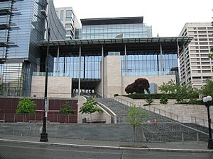
Columbia Center
Skyscraper in Seattle, US
Distance: Approx. 68 meters
Latitude and longitude: 47.60453,-122.33069
The Columbia Center, formerly named the Bank of America Tower and Columbia Seafirst Center, is a skyscraper in downtown Seattle, Washington, United States. The 76-story structure is the tallest building in the state of Washington, reaching a height of 933 ft (284 m). At the time of its completion, the Columbia Center was the tallest structure on the West Coast; as of 2017, it is the fourth-tallest, behind buildings in Los Angeles and San Francisco.

Seattle Municipal Tower
Skyscraper in downtown Seattle, Washington
Distance: Approx. 90 meters
Latitude and longitude: 47.6051,-122.3298
Seattle Municipal Tower is a skyscraper in downtown Seattle, Washington. At 220.07 m (722.0 ft), it is the fifth-tallest building in the city. Completed in 1990, it was initially named AT&T Gateway Tower and subsequently KeyBank Tower after its anchor tenants AT&T and KeyBank.

901 Fifth Avenue
Skyscraper in downtown Seattle, Washington
Distance: Approx. 111 meters
Latitude and longitude: 47.60583,-122.332
901 Fifth Avenue is a 163.38 m (536.0 ft) skyscraper in downtown Seattle, Washington. It was completed in 1973 and has 42 floors. It is the 11th tallest building in Seattle, and was designed by John Graham and Associates.

800 Fifth Avenue
Skyscraper in Seattle
Distance: Approx. 98 meters
Latitude and longitude: 47.6058,-122.3302
800 Fifth Avenue is a 166-meter (545 ft) skyscraper in Seattle, in the U.S. state of Washington. It was constructed from 1979 to 1981 and has 42 floors. It is the tenth-tallest building in Seattle and was designed by 3D/International.

F5 Tower
660-foot-tall skyscraper in Downtown Seattle, Washington
Distance: Approx. 21 meters
Latitude and longitude: 47.60527778,-122.33111111
F5 Tower (previously The Mark and Fifth and Columbia Tower) is a 660-foot-tall (200 m) skyscraper in Downtown Seattle, Washington. It consists of 44 floors and is the sixth-tallest building in Seattle. The tower consists of 516,000 square feet (47,900 m2) of office space leased entirely by F5 Networks and a 189-room luxury hotel operated by Lotte Hotels & Resorts.
Seattle City Hall
Government offices in Washington, U.S.
Distance: Approx. 89 meters
Latitude and longitude: 47.605061,-122.32982
Seattle City Hall (also known as the Seattle Municipal Building) is the home of the offices of the mayor and city council of Seattle, Washington, located between 4th Avenue and 5th Avenue in the downtown area of the city. Most city departments have their offices in the nearby Seattle Municipal Tower. In 2003, the Seattle city government moved into a new, "green" city hall building.
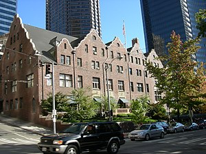
Rainier Club
United States historic place
Distance: Approx. 113 meters
Latitude and longitude: 47.60611111,-122.33083333
The Rainier Club is a private club in Seattle, Washington; it has been referred to as "Seattle's preeminent private club." Its clubhouse building, completed in 1904, is listed on the National Register of Historic Places. It was founded in 1888 in what was then the Washington Territory (statehood came the following year). As of 2008, the club has 1,300 members.
Forterra
Land conservation, stewardship and community building organization in Seattle, USA
Distance: Approx. 110 meters
Latitude and longitude: 47.605935,-122.331783
Forterra (formerly known as Cascade Land Conservancy), based in Seattle, Washington, US, is the state of Washington's largest land conservation, stewardship and community building organization dedicated solely to the region. Currently, Forterra operates in multiple counties. Principal offices are in Seattle, Roslyn, and Tacoma.

Daniels Recital Hall
Historic church in Washington, United States
Distance: Approx. 50 meters
Latitude and longitude: 47.6055,-122.3313
Daniels Recital Hall, formerly the First United Methodist Church, now The Sanctuary, is a preserved church sanctuary that has been re-purposed into a recital hall. It was built in 1908 on the southwest corner of Fifth Avenue and Marion Street in Seattle, Washington, United States. The recital hall opened in 2009 hosting concerts that use the already existing church acoustics.
4/C
Proposed supertall skyscraper in Seattle, Washington
Distance: Approx. 126 meters
Latitude and longitude: 47.6040184,-122.3314913
4/C, also known as 4th & Columbia, is a proposed supertall skyscraper in Seattle, Washington, United States. If built, the 1,020-foot-tall (310 m), 91-story tower would be the tallest in Seattle, surpassing the neighboring Columbia Center, and the first supertall in the Pacific Northwest. The project has been under development by Miami-based Crescent Heights since 2015 and undergone several design changes and modifications under three architecture firms.
Seattle Department of Transportation
Government agency in state Washington
Distance: Approx. 97 meters
Latitude and longitude: 47.605,-122.32972222
The Seattle Department of Transportation (SDOT) is a municipal government agency in Seattle, Washington that is responsible for the maintenance of the city's transportation systems, including roads, bridges, and public transportation. The agency is funded primarily by taxes that are supplemented by voter-approved levies from other sources; its budget in 2017 was $450 million.

Central Building (Seattle)
Building in Seattle, Washington, U.S.
Distance: Approx. 140 meters
Latitude and longitude: 47.60472222,-122.33277778
The Central Building is a historic building at 810 3rd Avenue in downtown Seattle, in the U.S. state of Washington.
Weather in this IP's area
clear sky
8 Celsius
5 Celsius
6 Celsius
9 Celsius
1023 hPa
85 %
1023 hPa
1017 hPa
10000 meters
4.47 m/s
6.26 m/s
120 degree
07:33:09
18:15:13