Country:
 Canada
Region:
City:
Latitude and Longitude:
Time Zone:
Postal Code:
IP information under different IP Channel
ip-api
Country
Region
City
ASN
Time Zone
ISP
Blacklist
Proxy
Latitude
Longitude
Postal
Route
IPinfo
Country
Region
City
ASN
Time Zone
ISP
Blacklist
Proxy
Latitude
Longitude
Postal
Route
MaxMind
Country
Region
City
ASN
Time Zone
ISP
Blacklist
Proxy
Latitude
Longitude
Postal
Route
Luminati
Country
CARegion
ab
City
edmonton
ASN
Time Zone
America/Edmonton
ISP
ASN-WIBAND-1
Latitude
Longitude
Postal
db-ip
Country
Region
City
ASN
Time Zone
ISP
Blacklist
Proxy
Latitude
Longitude
Postal
Route
ipdata
Country
Region
City
ASN
Time Zone
ISP
Blacklist
Proxy
Latitude
Longitude
Postal
Route
Popular places and events near this IP address

Sherwood Park
Urban service area in Alberta, Canada
Distance: Approx. 3516 meters
Latitude and longitude: 53.52333333,-113.30888889
Sherwood Park is a large hamlet in Alberta, Canada within Strathcona County that is recognized as an urban service area. It is located on traditional Treaty 6 territory, and adjacent to the City of Edmonton's eastern boundary. While long confined to generally south of Highway 16 (Yellowhead Trail), west of Highway 21 and north of Highway 630 (Wye Road), portions of Sherwood Park have expanded beyond Yellowhead Trail and Wye Road since the start of the 21st century.

Strathcona County
Municipality in Alberta, Canada
Distance: Approx. 3516 meters
Latitude and longitude: 53.52333333,-113.30888889
Strathcona County is a specialized municipality in the Edmonton Metropolitan Region within Alberta, Canada between Edmonton and Elk Island National Park. It forms part of Census Division No. 11.

Sherwood Park (electoral district)
Provincial electoral district in Alberta, Canada
Distance: Approx. 1722 meters
Latitude and longitude: 53.54,-113.31
Sherwood Park is a provincial electoral district for the Legislative Assembly of Alberta, Canada.

Edmonton—Sherwood Park (federal electoral district)
Federal electoral district in Alberta, Canada
Distance: Approx. 3401 meters
Latitude and longitude: 53.58,-113.33
Edmonton–Sherwood Park was a federal electoral district in Alberta, Canada, that was represented in the House of Commons of Canada from 2004 to 2015. It was a suburban riding in Edmonton.
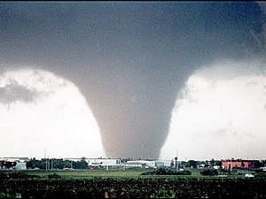
Edmonton tornado
1987 tornado in Alberta, Canada
Distance: Approx. 3921 meters
Latitude and longitude: 53.56,-113.36
The Edmonton tornado of 1987, an event also known as Black Friday to Edmontonians, was a powerful and devastating tornado that ripped through the eastern parts of Edmonton, Alberta, Canada and parts of neighbouring Strathcona County on the afternoon of Friday, July 31, 1987. It was one of seven other tornadoes in central Alberta the same day. The tornado peaked at F4 on the Fujita scale and remained on the ground for an hour, cutting a swath of destruction 30.8 km (19.1 mi) in length and up to 1.3 km (0.81 mi) wide in some places.
Salisbury Composite High School
Public secondary school in Sherwood Park, Alberta, Canada
Distance: Approx. 3296 meters
Latitude and longitude: 53.525,-113.3
Salisbury Composite High School, often referred to as Sal or Sal Comp, is a public high school located in Sherwood Park, Alberta, Canada.
Bev Facey Community High School
Public senior high school in Sherwood Park, Alberta, Canada
Distance: Approx. 3905 meters
Latitude and longitude: 53.52527778,-113.26899444
Bev Facey Community High School, known as Bev Facey, is a public high school for grades 10–12 in Sherwood Park, Strathcona County, Alberta, which falls under the jurisdiction of the Elk Island Public Schools Regional Division No. 14.
Sherwood Park Mall
Shopping mall in Sherwood Park, Alberta, Canada
Distance: Approx. 2692 meters
Latitude and longitude: 53.53089,-113.29343
Sherwood Park Mall is a shopping mall located in Sherwood Park, Alberta, Canada. It has 97 stores and services including Safeway, Cineplex Cinemas, Designer Shoe Warehouse and Indigo Books & Music. It is the only enclosed mall in Strathcona County.
Strathcona Community Hospital
Hospital in Alberta, Canada
Distance: Approx. 2231 meters
Latitude and longitude: 53.56805556,-113.27638889
The Strathcona Community Hospital is located in Sherwood Park, Alberta, Canada, and provides 27 hospital beds with sufficient infrastructure capacity for 36 additional beds in the future. The hospital opened on May 21, 2014. The hospital development was an issue in the Strathcona County municipal election, 2010.
Health First Strathcona
Hospital in Alberta, Canada
Distance: Approx. 2429 meters
Latitude and longitude: 53.53722222,-113.32361111
Health First Strathcona was primary care centre that opened in Sherwood Park, Alberta in February 2004. The facility was opened to complement the regular care provided by family physicians, by providing after hours care for illness and urgent injuries. The centre closed on May 20, 2014, with its services being transferred to the Strathcona Community Hospital, which opened a day later.
Sunridge Ski Area
Distance: Approx. 4695 meters
Latitude and longitude: 53.56416667,-113.37055556
Sunridge Ski Area is a ski area located off of 17 Street in Edmonton, Alberta. It is built on the bank of the North Saskatchewan River.
Archbishop Jordan High School
School in Sherwood Park, Alberta, Canada
Distance: Approx. 1613 meters
Latitude and longitude: 53.56638889,-113.28722222
Archbishop Jordan High School is an academic Catholic secondary school located in Sherwood Park, Alberta, Canada. It was founded in 1969 and is named after Archbishop Anthony Jordan. The school motto - scri crui crediti - is based on Jordan's motto; scio crui crediti and the school football team, the Scots, is named after Jordan's Scottish birthplace.
Weather in this IP's area
broken clouds
17 Celsius
16 Celsius
16 Celsius
18 Celsius
1005 hPa
43 %
1005 hPa
927 hPa
10000 meters
3.6 m/s
320 degree
56 %
07:14:47
19:38:54