72.142.149.68 - IP Lookup: Free IP Address Lookup, Postal Code Lookup, IP Location Lookup, IP ASN, Public IP
Country:
Region:
City:
Location:
Time Zone:
Postal Code:
IP information under different IP Channel
ip-api
Country
Region
City
ASN
Time Zone
ISP
Blacklist
Proxy
Latitude
Longitude
Postal
Route
Luminati
Country
Region
ab
City
ftsaskatchewan
ASN
Time Zone
America/Edmonton
ISP
CFCS
Latitude
Longitude
Postal
IPinfo
Country
Region
City
ASN
Time Zone
ISP
Blacklist
Proxy
Latitude
Longitude
Postal
Route
IP2Location
72.142.149.68Country
Region
alberta
City
calgary
Time Zone
America/Edmonton
ISP
Language
User-Agent
Latitude
Longitude
Postal
db-ip
Country
Region
City
ASN
Time Zone
ISP
Blacklist
Proxy
Latitude
Longitude
Postal
Route
ipdata
Country
Region
City
ASN
Time Zone
ISP
Blacklist
Proxy
Latitude
Longitude
Postal
Route
Popular places and events near this IP address

Calgary-East
Provincial electoral district in Alberta, Canada
Distance: Approx. 1672 meters
Latitude and longitude: 51.05,-113.97
Calgary-East (formally styled Calgary East) is a provincial electoral district in Alberta, Canada. The district is mandated to return a single member to the Legislative Assembly of Alberta. Calgary-East has existed twice, the first incarnation was created from Calgary North East in the redistribution of 1963.

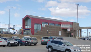
Marlborough station
Light rail station in Calgary, Alberta, Canada
Distance: Approx. 713 meters
Latitude and longitude: 51.05888889,-113.98166667
Marlborough Station is a Calgary C-Train light rail station in the Calgary Northeast neighbourhood of Marlborough. It serves the Northeast Leg of the Blue Line and opened on April 27, 1985, as part of the original Northeast (202) line. The station is located in the median of 36 Street NE, located near its intersection with 8 Avenue NE/Marlborough Drive NE. The station is 6.5 km (4.0 mi) from the City Hall Interlocking and is located near Calgary's Marlborough neighbourhood and also serves nearby businesses along 36 Street NE, including Marlborough Mall.

Franklin station (Calgary)
Light rail station in Calgary, Alberta, Canada
Distance: Approx. 1089 meters
Latitude and longitude: 51.04722222,-113.99444444
Franklin Station is a Calgary C-Train light rail station in Calgary, Alberta, Canada. It serves the Northeast Line (Route 202) and opened on April 27, 1985, as part of the original route. The station is located in the median of Memorial Drive, just west of the intersection with 28 Street SE. The station is 4.7 km (2.92 mi) from the City Hall Interlocking.

Barlow/Max Bell station
Light rail station in Calgary, Alberta, Canada
Distance: Approx. 1663 meters
Latitude and longitude: 51.04555556,-114.00694444
Barlow/Max Bell station is a CTrain light rail station in Calgary, Alberta, Canada. It serves the Northeast Line (Route 202). It opened on April 27, 1985, as part of the original Northeast line.

Max Bell Centre (Calgary)
Ice hockey arena in Calgary, Alberta, Canada
Distance: Approx. 1837 meters
Latitude and longitude: 51.04222222,-114.00361111
Max Bell Centre (commonly Max Bell Arena) is an ice hockey arena in Calgary, Alberta, Canada, in the community of Albert Park/Radisson Heights. It seats 2,121 for hockey, with a standing room capacity of over 3,000. It is named after Max Bell, a philanthropist who was a prominent businessman in Calgary.

Marlborough Mall
Shopping mall in Calgary, Alberta, Canada
Distance: Approx. 936 meters
Latitude and longitude: 51.05472222,-113.97833333
Marlborough Mall is a shopping mall located in Calgary, Alberta, Canada. Opened in November 1971, the mall has expanded several times and today includes approximately 100 stores and services, and encompasses 570,837 square feet (53,032.5 m2) of retail floor space. The mall also featured a Safeway until the 1990s, when the store moved to its own location west of 36th Street.

Sunridge Mall
Shopping mall in Alberta, Canada
Distance: Approx. 2001 meters
Latitude and longitude: 51.07444444,-113.98583333
Sunridge Mall is a major enclosed shopping mall in Calgary, Alberta containing 830,599 square feet / 77,165 m² of retail space. It is in the city's northeast quadrant, located at the corner of 36 Street NE and 20 Avenue NE, adjacent to the Rundle LRT station, sunridge Spectrum Movie Theatre, and the Peter Lougheed Centre. Sunridge Mall is owned and operated by Primaris Management Inc, a division of H&R REIT. Originally opened in October 1981, Sunridge Mall completed a $50 million renovation and expansion program.

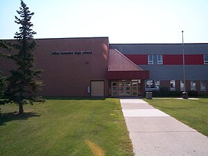
Father Lacombe High School
High school in Calgary, Alberta, Canada
Distance: Approx. 1105 meters
Latitude and longitude: 51.048,-113.984
Father Lacombe High School is a Catholic senior high school in Calgary, Alberta, Canada, named after Father Albert Lacombe. It has classes for grades 10 to 12 and is located in the southeast quadrant community of Radisson Heights, Calgary.

Albert Park/Radisson Heights
Neighbourhood in Calgary, Alberta, Canada
Distance: Approx. 1258 meters
Latitude and longitude: 51.04555556,-113.98944444
Albert Park/Radisson Heights is a residential neighbourhood in the southeast quadrant of Calgary, Alberta. It is bounded to the west by the Bow River and Deerfoot Trail, to the north by Memorial Drive and to the south by 17 Avenue SE. The community of Forest Lawn lies to the east. This community, established in 1910, enjoys ample open space, is well provided with public and separate schools, has good access to shopping and citywide transportation routes, and has views of the Bow River Valley, the Downtown and the Canadian Rockies.
Marlborough, Calgary
Neighbourhood in Calgary, Alberta, Canada
Distance: Approx. 1653 meters
Latitude and longitude: 51.05944444,-113.96805556
Marlborough is a residential neighbourhood in the northeast quadrant of Calgary, Alberta. It is bounded by the 16 Avenue NE (Trans-Canada Highway) to the north, 52 Street NE to the east, Memorial Drive to the south and 36 Street NE to the west. The community is served by the Marlborough station of the C-Train LRT system, and Marlborough Mall is located in the southwest corner of the neighbourhood.
Mayland Heights, Calgary
Neighbourhood in Calgary, Alberta, Canada
Distance: Approx. 1624 meters
Latitude and longitude: 51.06138889,-114.01333333
Mayland Heights is a residential neighbourhood in the northeast/southeast quadrant of Calgary, Alberta. It is bounded by Barlow Trail to the east, Memorial Drive to the south, Deerfoot Trail to the west and Trans-Canada Highway to the north. The neighbourhood of Radisson heights is to the south, Franklin/Marlborough to the east.
Albert Park, Alberta
Former village in Alberta, Canada
Distance: Approx. 1804 meters
Latitude and longitude: 51.041,-113.997
Albert Park is a former village in Alberta, Canada that is now within the City of Calgary. Its village status ceased after just over a year upon amalgamating with nearby Forest Lawn to the east.
Weather in this IP's area
broken clouds
1 Celsius
-2 Celsius
-0 Celsius
2 Celsius
1004 hPa
63 %
1004 hPa
875 hPa
10000 meters
2.06 m/s
30 degree
75 %