72.140.238.94 - IP Lookup: Free IP Address Lookup, Postal Code Lookup, IP Location Lookup, IP ASN, Public IP
Country:
Region:
City:
Location:
Time Zone:
Postal Code:
ISP:
ASN:
language:
User-Agent:
Proxy IP:
Blacklist:
IP information under different IP Channel
ip-api
Country
Region
City
ASN
Time Zone
ISP
Blacklist
Proxy
Latitude
Longitude
Postal
Route
db-ip
Country
Region
City
ASN
Time Zone
ISP
Blacklist
Proxy
Latitude
Longitude
Postal
Route
IPinfo
Country
Region
City
ASN
Time Zone
ISP
Blacklist
Proxy
Latitude
Longitude
Postal
Route
IP2Location
72.140.238.94Country
Region
alberta
City
edmonton
Time Zone
America/Edmonton
ISP
Language
User-Agent
Latitude
Longitude
Postal
ipdata
Country
Region
City
ASN
Time Zone
ISP
Blacklist
Proxy
Latitude
Longitude
Postal
Route
Popular places and events near this IP address

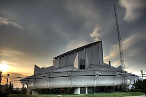
Telus World of Science Edmonton
Science centre in Alberta, Canada
Distance: Approx. 2665 meters
Latitude and longitude: 53.5611,-113.5639
Telus World of Science Edmonton (TWOSE) is a broad-based science centre in Edmonton, Alberta, Canada, operated by the (non-profit) Edmonton Space & Science Foundation. The centre is located on the southwest corner of Coronation Park in the neighborhood of Woodcroft. The science centre houses 144,430 sq.

Edmonton International Speedway
Distance: Approx. 2571 meters
Latitude and longitude: 53.607,-113.557
Edmonton International Speedway, also known as Speedway Park, was a 251-acre (1.02 km2) multi-track auto racing facility located in the present Cumberland and Hudson neighbourhoods of Edmonton, Alberta, Canada. The facility featured a 1⁄4-mile (400 m) dragstrip, a 2.53-mile (4.07 km) 14-turn road course, and a 1⁄4-mile short oval. At its peak, it had capacity for over 30,000 fans.

Edmonton station (Via Rail)
Railway station in Alberta, Canada
Distance: Approx. 2565 meters
Latitude and longitude: 53.57888889,-113.53083333
Edmonton station (French: gare d'Edmonton; IATA: XZL) or Edmonton Train Station, is the main inter-city train station in Edmonton, Alberta, Canada, operated by Via Rail. The railway station is located approximately 5.5 kilometres northwest of Downtown Edmonton on a spur off the Canadian National Railway near the former site of the Edmonton City Centre Airport. Served by Via Rail's The Canadian, the station is unusually located on a branch off the main line, meaning that trains must either reverse into or out.
Holy Cross Cemetery (Edmonton)
Roman Catholic cemetery in Alberta, Canada
Distance: Approx. 2778 meters
Latitude and longitude: 53.60833333,-113.58277778
Holy Cross Cemetery is a Roman Catholic cemetery located at 14611 Mark Messier Trail NW in Edmonton, Alberta, Canada. The cemetery is owned and operated by the Roman Catholic Archdiocese of Edmonton and was opened by the archdiocese in 1954.

Edmonton-Calder
Defunct provincial electoral district in Alberta, Canada
Distance: Approx. 2170 meters
Latitude and longitude: 53.59,-113.6
Edmonton-Calder was a provincial electoral district in Alberta, Canada, mandated to return a single member to the Legislative Assembly of Alberta using the first past the post method of voting from 1971 to 1993 and again from 1996 to 2019.
Dunvegan Yards
Distance: Approx. 595 meters
Latitude and longitude: 53.5884,-113.5615
The Dunvegan Yards were rail yards in Edmonton, Alberta, named after, and originally owned by, the Edmonton, Dunvegan and British Columbia Railway. Located just east of the St. Albert Trail and connected to the Grand Trunk Pacific's transcontinental mainline, the yards were the southern terminus of the ED&BC which began construction in 1912, though the yards were not officially surveyed until 1914.
Coralwood Adventist Academy
K–12 school in Edmonton, Alberta (est. 1957)
Distance: Approx. 1575 meters
Latitude and longitude: 53.5729249,-113.5556196
Coralwood Adventist Academy is an Independent K–12 Christian school located in Edmonton, Alberta, Canada, that is affiliated with the Seventh-day Adventist Church.
Alberta Genealogical Society
Distance: Approx. 1665 meters
Latitude and longitude: 53.569944,-113.568442
The Alberta Genealogical Society (AGS) is a non-profit educational organization headquartered at 14315 118 Ave, Edmonton, Alberta, Canada. Founded in 1970, AGS is one of the largest genealogical societies in Canada. Its mission is "to promote interest in genealogy and genealogical research through a provincial association, by providing opportunities for the exchange of genealogical ideas and information." AGS publishes Relatively Speaking, a scholarly magazine and newsletter, and the organization conducts educational programs, and maintains a website with a database for its members and research guides for the general public.

Edmonton Association of the Deaf
Nonprofit organization
Distance: Approx. 2430 meters
Latitude and longitude: 53.56309983,-113.566342
The Edmonton Association of the Deaf (E.A.D.) is an Albertan non-governmental organization that works to promote the interests of the Deaf community in Edmonton, Alberta, Canada.

Edmonton Police Association
Building in Edmonton, AB
Distance: Approx. 2695 meters
Latitude and longitude: 53.560717,-113.566349
The Edmonton Police Association (E.P.A.) is a labour union in Edmonton, Alberta, Canada that represents members of the Edmonton Police Service.

Centre for Family Literacy
Distance: Approx. 1738 meters
Latitude and longitude: 53.569283,-113.568413
The Centre for Family Literacy is a non-profit organization in Edmonton, Alberta, Canada.

Christian Credit Union
Credit union in Alberta, Canada
Distance: Approx. 1407 meters
Latitude and longitude: 53.5975,-113.5667
The Christian Credit Union is a Canadian credit union that provides banking services in Alberta. It was founded by Dutch-Canadian settlers in 1952. Its name comes from its relationship with Dutch-Canadian settlers that belonged to the Christian Reformed Church.
Weather in this IP's area
overcast clouds
-1 Celsius
-5 Celsius
-2 Celsius
0 Celsius
1016 hPa
69 %
1016 hPa
934 hPa
10000 meters
3.6 m/s
250 degree
100 %