Country:
 USA
USARegion:
City:
Latitude and Longitude:
Time Zone:
Postal Code:
IP information under different IP Channel
ip-api
Country
Region
City
ASN
Time Zone
ISP
Blacklist
Proxy
Latitude
Longitude
Postal
Route
IPinfo
Country
Region
City
ASN
Time Zone
ISP
Blacklist
Proxy
Latitude
Longitude
Postal
Route
MaxMind
Country
Region
City
ASN
Time Zone
ISP
Blacklist
Proxy
Latitude
Longitude
Postal
Route
Luminati
Country
USRegion
ia
City
anamosa
ASN
Time Zone
America/Chicago
ISP
MVLINK
Latitude
Longitude
Postal
db-ip
Country
Region
City
ASN
Time Zone
ISP
Blacklist
Proxy
Latitude
Longitude
Postal
Route
ipdata
Country
Region
City
ASN
Time Zone
ISP
Blacklist
Proxy
Latitude
Longitude
Postal
Route
Popular places and events near this IP address

Anamosa, Iowa
City in Iowa, United States
Distance: Approx. 616 meters
Latitude and longitude: 42.10888889,-91.28138889
Anamosa is a city in Jones County, Iowa, United States. The population was 5,450 at the 2020 census. It is the county seat of Jones County.

Anamosa State Penitentiary
United States historic place
Distance: Approx. 213 meters
Latitude and longitude: 42.111,-91.291
Anamosa State Penitentiary is a maximum security penitentiary prison located in the Jones County community of Anamosa, Iowa – approximately 25 miles (40 km) northeast of Cedar Rapids, Iowa.
Anamosa Community School District
Public school district in Anamosa, Iowa, United States
Distance: Approx. 494 meters
Latitude and longitude: 42.105952,-91.287429
The Anamosa Community School District (ACSD) is a rural public school district headquartered in Anamosa, Iowa. It encompasses part of Jones County and a small portion of eastern Linn County. The cities of Anamosa, Martelle and Morley are in the school district, along with the unincorporated communities of Amber, Fairview and Viola.
National Motorcycle Museum (Anamosa, Iowa)
Distance: Approx. 458 meters
Latitude and longitude: 42.108,-91.284
The National Motorcycle Museum was a non-profit museum located in Anamosa, Iowa. It was founded in 1989 by motorcycle builders, racers, and riders. Its purpose to maintain the experience of bikes past and present as well as motorcycle memorabilia, documents and actual vintage bikes from as far back as 1903.

Jones County Courthouse (Iowa)
United States historic place
Distance: Approx. 150 meters
Latitude and longitude: 42.10944444,-91.29
The Jones County Courthouse in Anamosa, Iowa, United States was built in 1937. It was listed on the National Register of Historic Places in 2003 as the "Jones County Court House." It is a part of the PWA-Era County Courthouses of IA Multiple Properties Submission, and is the third building the county has used for court functions and county administration.
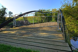
Lower Road Bridge
United States historic place
Distance: Approx. 1512 meters
Latitude and longitude: 42.11477778,-91.30588889
Lower Road Bridge is a historic structure located northwest of Anamosa, Iowa, United States. It spans Buffalo Creek for 160 feet (49 m). The King Iron Bridge and Manufacturing Co.
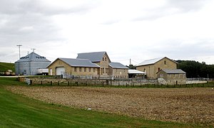
Farm No. 1, Iowa Men's Reformatory
United States historic place
Distance: Approx. 1132 meters
Latitude and longitude: 42.10916667,-91.30222222
Farm No. 1, Iowa Men's Reformatory, also known as the West Farm, is located west of Anamosa, Iowa, United States. It was listed as a historic district on the National Register of Historic Places in 1992.

Anamosa Main Street Historic District
Historic district in Iowa, United States
Distance: Approx. 346 meters
Latitude and longitude: 42.10825,-91.28544444
The Anamosa Main Street Historic District is a nationally recognized historic district located in Anamosa, Iowa, United States. It was listed on the National Register of Historic Places in 2009. At the time of its nomination the district consisted of 52 resources, including 42 contributing buildings, one contributing structure, and nine non-contributing buildings.

Anamosa Public Library
Distance: Approx. 493 meters
Latitude and longitude: 42.10661111,-91.28530556
The Anamosa Library & Learning Center, formerly the Anamosa Public Library, is located in Anamosa, Iowa, United States. The original building, built in 1903, was listed on the National Register of Historic Places in 1983. A new facility, with triple the floor space of the old, was opened to the public in 2004.
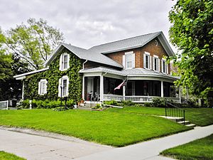
Edmund and Mary Ann Walworth Booth House
Historic house in Iowa, United States
Distance: Approx. 468 meters
Latitude and longitude: 42.10686111,-91.28533333
The Edmund and Mary Ann Walworth Booth House is a historic building located in Anamosa, Iowa, United States. Raised in Longmeadow, Massachusetts, Edmund Booth contracted meningitis at age four and lost part of his hearing. By the time he was eight he was totally deaf.

Col. William T. and Elizabeth C. Shaw House
Historic house in Iowa, United States
Distance: Approx. 1617 meters
Latitude and longitude: 42.10247222,-91.27211111
The Col. William T. and Elizabeth C. Shaw House is a historic building located in Anamosa, Iowa, United States. Shaw settled in this area in 1854, and as a building contractor was responsible for the construction of many of the commercial blocks in the central business district.
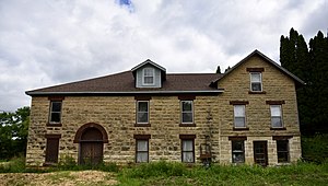
Rick's Brewery
United States historic place
Distance: Approx. 1000 meters
Latitude and longitude: 42.11333333,-91.3
Rick's Brewery, also known as Minnie Creek Brewery and Old Brewery, is a historic building located west of Anamosa, Iowa, United States. John Kohl bought the property in 1858, and he joined with John B. Kraus and Wilhelm Romberg to build the initial part of the building the following year. The three-story structure was built of native limestone that was quarried 2 miles (3.2 km) to the west.
Weather in this IP's area
broken clouds
21 Celsius
21 Celsius
19 Celsius
22 Celsius
1013 hPa
75 %
1013 hPa
983 hPa
10000 meters
4.04 m/s
8.18 m/s
115 degree
62 %
06:48:54
19:09:28