Country:
Region:
City:
Latitude and Longitude:
Time Zone:
Postal Code:
IP information under different IP Channel
ip-api
Country
Region
City
ASN
Time Zone
ISP
Blacklist
Proxy
Latitude
Longitude
Postal
Route
Luminati
Country
Region
ab
City
calgary
ASN
Time Zone
America/Edmonton
ISP
ASN-WIBAND-1
Latitude
Longitude
Postal
IPinfo
Country
Region
City
ASN
Time Zone
ISP
Blacklist
Proxy
Latitude
Longitude
Postal
Route
db-ip
Country
Region
City
ASN
Time Zone
ISP
Blacklist
Proxy
Latitude
Longitude
Postal
Route
ipdata
Country
Region
City
ASN
Time Zone
ISP
Blacklist
Proxy
Latitude
Longitude
Postal
Route
Popular places and events near this IP address

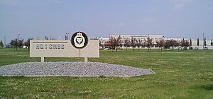
CFB Edmonton
Canadian Forces base in Alberta
Distance: Approx. 6600 meters
Latitude and longitude: 53.66916667,-113.47555556
3rd Canadian Division Support Base Edmonton, formerly known as and commonly referred to as CFB Edmonton is a Canadian Forces base in Sturgeon County adjacent to the City of Edmonton in Alberta, Canada. It is also known as Edmonton Garrison or "Steele Barracks".

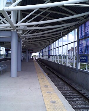
Clareview station
Light rail station in Edmonton, Alberta, Canada
Distance: Approx. 6324 meters
Latitude and longitude: 53.60166667,-113.41138889
Clareview station is an Edmonton LRT station in Edmonton, Alberta, Canada. It serves the Capital Line and is currently the northern terminus of the line. It is a ground-level station located near 42 Street and 139 Avenue, and is named after the northeast Edmonton district of Clareview.

Alberta Hospital Edmonton
Psychiatric Hospital in Canada (1923-)
Distance: Approx. 2109 meters
Latitude and longitude: 53.6363,-113.3733
Alberta Hospital Edmonton is a psychiatric hospital operating under the governance of Alberta Health Services. It is located in the northeastern portion of Edmonton, Alberta, Canada, and was founded on July 1, 1923. The site is serviced by Edmonton Transit Service bus route 121.
Evergreen, Edmonton
Neighbourhood in Edmonton, Alberta, Canada
Distance: Approx. 3253 meters
Latitude and longitude: 53.63111111,-113.35
Evergreen, or Evergreen Community, is a neighbourhood in the rural northeast portion of the City of Edmonton, Alberta, Canada. A manufactured home community, it is located at the northwest corner of 167 Avenue NW and Meridian Street. Evergreen had a population of 1,450 according to Edmonton's 2012 municipal census.

Edmonton Composting Facility
Municipal site in Canada, 1999 to 2019
Distance: Approx. 6993 meters
Latitude and longitude: 53.59638889,-113.34027778
The Edmonton Composting Facility was the site of the Canadian City of Edmonton's co-composting system for processing organic waste. Co-composting involves mixing household waste with biosolids (sewage sludge), and using microorganisms to break them down into simple compost. Waste was separated from general garbage.
Edmonton Institution
Prison in Alberta, Canada
Distance: Approx. 3599 meters
Latitude and longitude: 53.67694444,-113.33833333
The Edmonton Institution (French: Établissement d'Edmonton) is a maximum security federal institution located in the northeastern part of Edmonton, Alberta. It is operated by Correctional Service of Canada.
Northeast Community Health Centre
Hospital in Edmonton, Alberta, Canada
Distance: Approx. 6212 meters
Latitude and longitude: 53.60416667,-113.41722222
The Northeast Community Health Centre (NECHC) is a community health centre located in Northeast-Edmonton. It provides medical services through Alberta Health Services, including a 24/7 emergency department.
Clareview, Edmonton
Area in Alberta, Canada
Distance: Approx. 6232 meters
Latitude and longitude: 53.6,-113.396
Clareview is a residential area in the northeast portion of the city of Edmonton in Alberta, Canada. It was established in 1972 through Edmonton City Council's adoption of the Clareview Outline Plan, which guides the overall development of the area.
Pilot Sound, Edmonton
Area in Alberta, Canada
Distance: Approx. 3586 meters
Latitude and longitude: 53.635,-113.421
Pilot Sound is a residential area in the northeast portion of the City of Edmonton in Alberta, Canada. It was established in 1981 through Edmonton City Council's adoption of the Pilot Sound Area Structure Plan, which guides the overall development of the area.
Lake District, Edmonton
Area in Alberta, Canada
Distance: Approx. 6633 meters
Latitude and longitude: 53.628,-113.468
Lake District or Edmonton North is a residential area in the northeast portion of the City of Edmonton in Alberta, Canada. It was established in 1979 through Edmonton City Council's adoption of the Edmonton North Area Structure Plan, which guides the overall development of the area.
Horsehills Creek
River in Alberta, Canada
Distance: Approx. 4260 meters
Latitude and longitude: 53.63302,-113.32556
Horsehills Creek is a creek that flows in the far northeastern corridor of the city of Edmonton, Alberta, Canada. The creek is a minor tributary to the North Saskatchewan River and is surrounded by agricultural fields and native vegetation. The City of Edmonton considers Horsehills Creek a designated protected site, because of the flora and fauna located in patches of forest and wetlands.
Edmonton-Belmont
Defunct provincial electoral district in Alberta, Canada
Distance: Approx. 6768 meters
Latitude and longitude: 53.595,-113.395
Edmonton-Belmont was a provincial electoral district in Alberta, Canada, mandated to return a single member to the Legislative Assembly of Alberta using the first past the post method of voting from 1971 to 1993.
Weather in this IP's area
light snow
1 Celsius
-4 Celsius
0 Celsius
1 Celsius
1017 hPa
95 %
1017 hPa
937 hPa
8047 meters
4.92 m/s
4.92 m/s
301 degree
100 %
07:41:57
16:52:17